Markers found in the field, types, uses and references |


 Colorado Prospector - Gem and mineral prospecting and mining forums > Prospecting, Mineral Collecting and Treasure Hunting Forums > Prospectors and Rockhounding Field Work
  |
Markers found in the field, types, uses and references |
 Feb 14 2010, 06:23 PM Feb 14 2010, 06:23 PM
Post
#1
|
|
 Master Mucker!  Group: Admin Posts: 4,149 Joined: 7-October 03 From: Colorado Member No.: 3 |
Hello prospectors,
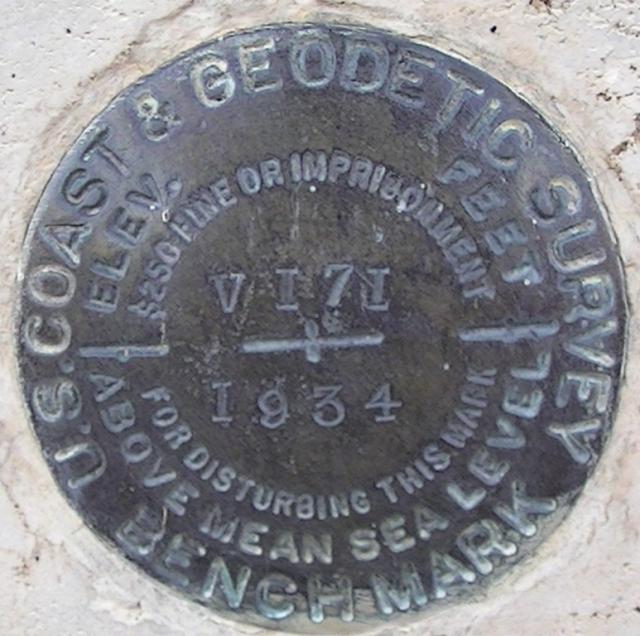
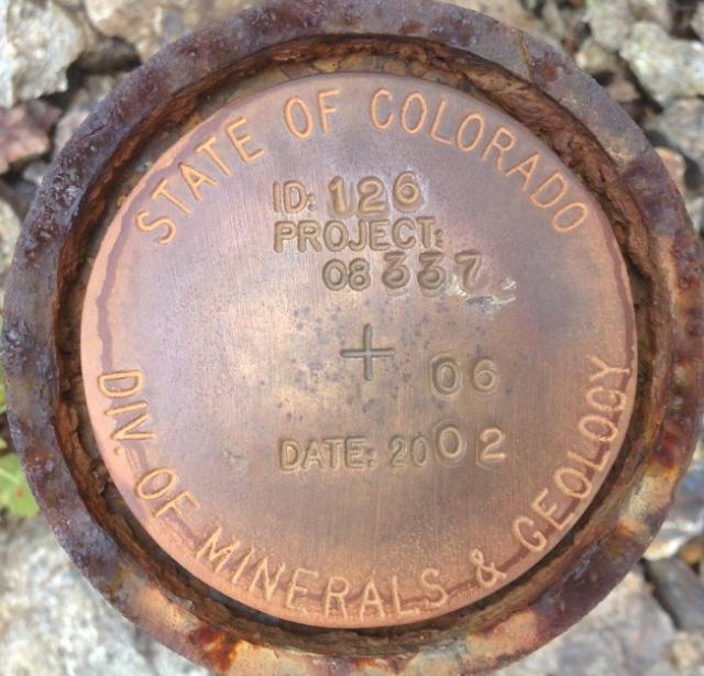
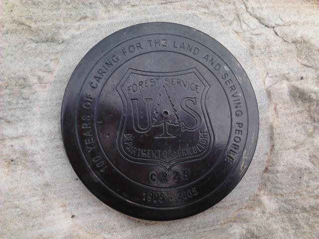
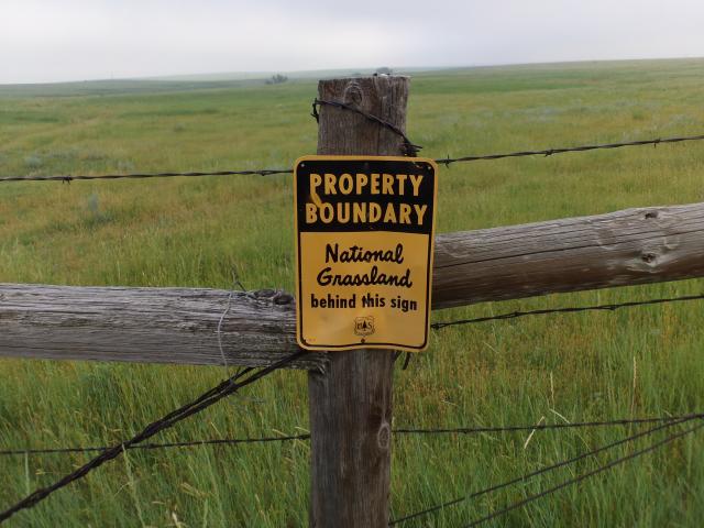
We thought a thread discussing markers (survey, claim, FS, BLM etc) we all find in the field might be a good one for information and referencing. Tampering with any survey markers, claim markers, FS and BLM signs or signage associated with any of them (including posts) is a crime. Do not tamper with them in the field. I and I'm sure others will add to them as time goes. If you have pictures of one you've found and want to add, or have questions about, feel free to post them up here in this thread. This one is self explaning and also are normally found in a shorter nearly square shape stating the same as this newer type. "behind the sign (yes orientated as posted) is national forest land. Sometimes you'll find two or more close near corners at 90' angles showing the corner property lines of the NF. 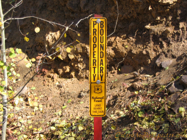 This is an upright marker and warning against tamper for a survey pin that also includes the surveyed information on the lower plate. I'm betting this survey pin has a history of disappearing. The lower signs are not often used either as the same information is also found on the pin itself or the survey records from the pin. They can be handy for the hard to find survey markers. 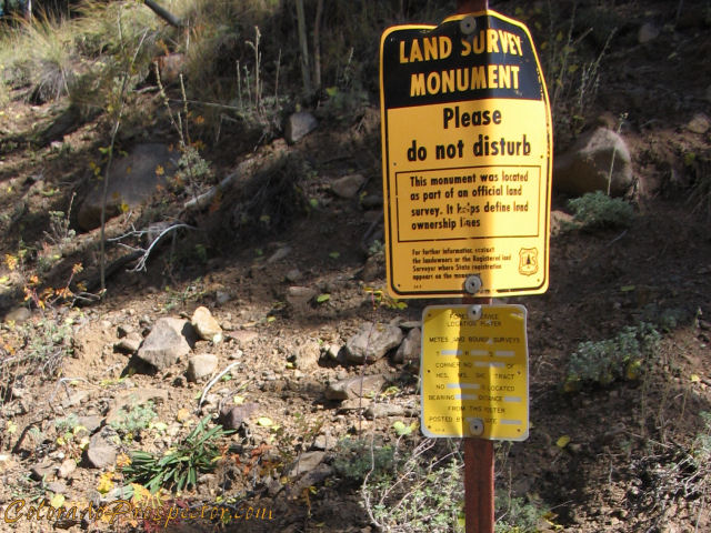 This is a BLM surveyors pin, aluminum 1.5 inch size. Information on this will lead you to the proper survey file for this tract surveyed. Private surveyors also use pins of this style and size and also will have information to reference their survey file. (once recorded - 1 year time allowed to file for surveyors) BLM also use a large 3 inch brass marker for section corners which will be added in the future. 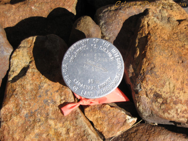 What markers have you come across in the field? CP -------------------- CP-Owner/Administrator
www.ColoradoProspector.com IF YOU USE IT, THE GROUND PRODUCED IT! MINERS MAKE "IT" HAPPEN!! |
 |
 
|
|
Feb 14 2010, 09:01 PM
Post
#2
|
|||||
 Rock Bar! Group: Members Posts: 613 Joined: 16-October 08 From: Central Colorado Member No.: 6,813 |
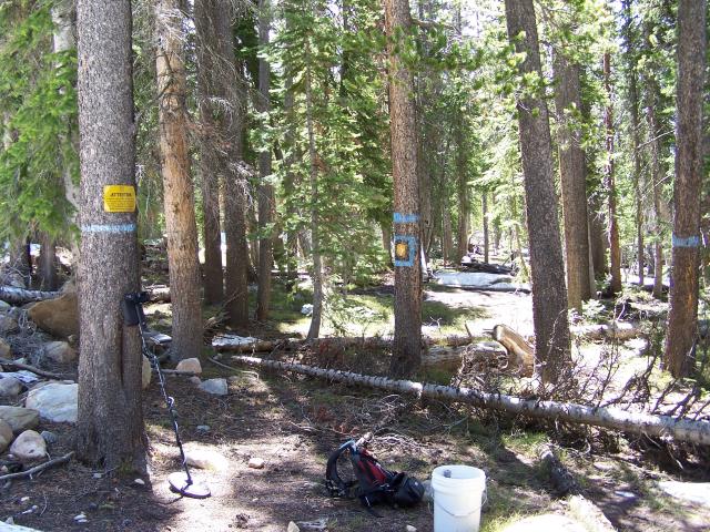
In some locations, USFS will mark trees near the monument so as to make them easier to locate. I've seen tree bark removed, aluminum tags and as shown below, spray paint...
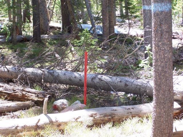
This really is helpfull when you are searching for a monument in unfamilair or very remote areas. It would be easy to miss the survey point if it weren't for the tree painting and red post in the middle of this forested location...
Here is a couple of photos of one of my claim corner posts that was staked next to a USFS monument out in the forest. My survey grade gps helped me hike straight to this spot. As you can see, the gps pinpoint I used used as reference to find the stake location is also very, very close to the actual monument that had been set by surveyors building the fence many years before GPS was invented!
ASTROBLEME -------------------- Annual Dues Paying Member Since 2008
Tonko Mining Company "Some day this crater is going to be a greatly talked about place, and if the above credit is due, as is certainly the case, I would like to have it generally known for the sake of the children." Daniel Moreau Barringer 2/1/1912 in a letter about the Barringer Meteorite Crater, Arizona USA |
||||
|
|
|
||||
|
Feb 15 2010, 06:07 AM
Post
#3
|
|
|
russau Group: Members Posts: 2,841 Joined: 4-December 03 From: st.louis missouri Member No.: 43 |
most of the markers i see are laying on their side or their tandeled in the brush from someone throwing them !
|
|
|
|
|
Feb 15 2010, 12:09 PM
Post
#4
|
|
|
Master Mucker! Group: Admin Posts: 4,149 Joined: 7-October 03 From: Colorado Member No.: 3 |
QUOTE (russau @ Feb 15 2010, 05:07 AM)  most of the markers i see are laying on their side or their tandeled in the brush from someone throwing them ! Yep Russ, that is why a thread like this could be useful to everyone too. And remember everyone, even if the markers are toppled, tossed off to the side or completely gone, YOU ARE RESPONSIBLE in the field to know your location and status of lands you are accessing. -------------------- CP-Owner/Administrator
www.ColoradoProspector.com IF YOU USE IT, THE GROUND PRODUCED IT! MINERS MAKE "IT" HAPPEN!! |
|
|
|
|
Sep 25 2013, 08:31 AM
Post
#5
|
|
 Shovel Buster! Group: Members Posts: 52 Joined: 1-April 13 From: Saguache, Co. Member No.: 65,104 |
|
|
|
|
|
Mar 10 2015, 08:56 AM
Post
#6
|
|
 Master Mucker! Group: Admin Posts: 7,187 Joined: 7-October 03 From: Colorado Member No.: 4 |
This is a great thread so I thought I would bump it back up for all to learn from.
Any other field markers found? We would love to see them. -------------------- Education is the key to the future,
and participation opens the door to opportunity. Discover your prospecting independence & success! ColoradoProspector.com Owner/Webmaster Core team member ♥  |
|
|
|
|
Mar 10 2015, 11:56 AM
Post
#7
|
||
 Master Mucker! Group: Members Posts: 1,282 Joined: 13-January 14 From: Lakewood, Colorado Member No.: 116,305 |
I don't know if this counts, but I found it on one of our travels.
Attached thumbnail(s)
|
|
|
|
|
|
|
Mar 10 2015, 05:05 PM
Post
#8
|
|
|
Master Mucker! Group: Admin Posts: 4,149 Joined: 7-October 03 From: Colorado Member No.: 3 |
That's an interesting type I haven't seen before fenixsmom. Was it for a survey or maybe a commemorative marker of some kind?
Sure it fits perfectly here, it's a FS marker you found in the field isn't it? 
-------------------- CP-Owner/Administrator
www.ColoradoProspector.com IF YOU USE IT, THE GROUND PRODUCED IT! MINERS MAKE "IT" HAPPEN!! |
|
|
|
|
Mar 10 2015, 05:45 PM
Post
#9
|
|
|
Master Mucker! Group: Members Posts: 1,282 Joined: 13-January 14 From: Lakewood, Colorado Member No.: 116,305 |
Its a location marker for Mt. Evans. I typed the number in Google and it brought up the spot I was at. Pretty nifty!
|
|
|
|
|
Mar 12 2015, 09:04 AM
Post
#10
|
|
|
Master Mucker! Group: Admin Posts: 7,187 Joined: 7-October 03 From: Colorado Member No.: 4 |
 Very cool Jessie! Love those field markers, they always have so much to tell. Very cool Jessie! Love those field markers, they always have so much to tell. 
-------------------- Education is the key to the future,
and participation opens the door to opportunity. Discover your prospecting independence & success! ColoradoProspector.com Owner/Webmaster Core team member ♥ |
|
|
|
|
Jun 24 2015, 05:07 PM
Post
#11
|
||
 Rock Bar! Group: Members Posts: 898 Joined: 9-January 14 From: Denver, CO Member No.: 116,265 |
Went looking for barite in eastern Colorado. Was happy to see this sign and an access gate.
-------------------- |
|
|
|
|
|
|
Jun 24 2015, 05:11 PM
Post
#12
|
|
 Moderator Group: Members Posts: 4,459 Joined: 25-August 09 From: way on up thar Member No.: 6,983 |
Interesting.... Pawnee?
-------------------- /l ,[____], l---L-OlllllllO- ()_) ()_)--o-)_) BLACK SANDS MATTER! Very Happy CP Lifetime Member CP CORE TEAM Referral Code CE213 |
|
|
|
|
Jun 25 2015, 03:40 PM
Post
#13
|
|
|
Rock Bar! Group: Members Posts: 898 Joined: 9-January 14 From: Denver, CO Member No.: 116,265 |
QUOTE (swizz @ Jun 24 2015, 06:11 PM) Interesting.... Pawnee? Yes. Pawnee National Grassland -------------------- |
|
|
|
|
Jul 7 2016, 03:07 PM
Post
#14
|
|||
|
Master Mucker! Group: Admin Posts: 7,187 Joined: 7-October 03 From: Colorado Member No.: 4 |
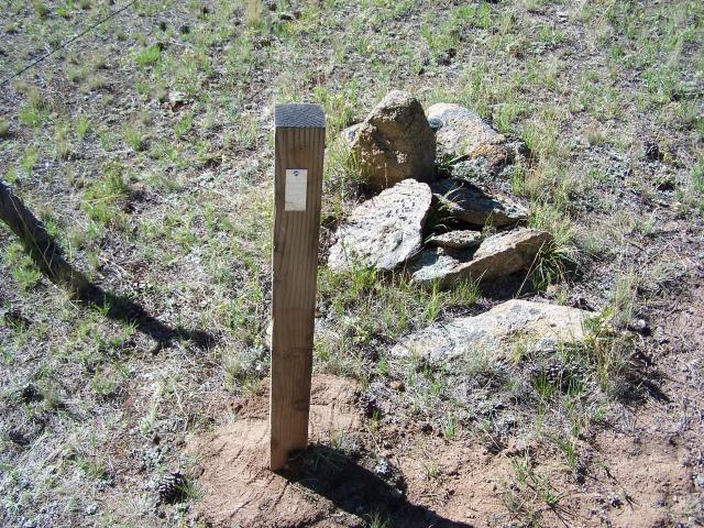
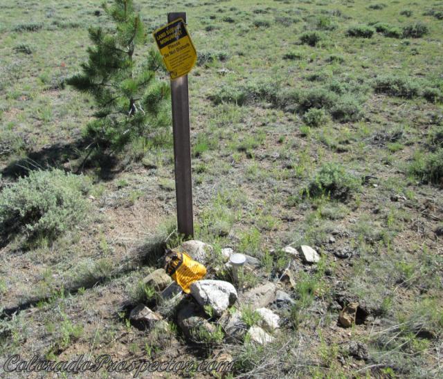
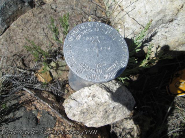
Here is a marker (survey pin) we found in the field. It's marking a corner along a National forest boundary. Here is a picture of what it looks like when you walk up on it...
A close look at the pin itself....
-------------------- Education is the key to the future,
and participation opens the door to opportunity. Discover your prospecting independence & success! ColoradoProspector.com Owner/Webmaster Core team member ♥ |
||
|
|
|
||
|
Jul 7 2016, 11:46 PM
Post
#15
|
|
|
Shovel Buster! Group: Members Posts: 100 Joined: 24-May 15 Member No.: 120,476 |
Denise,
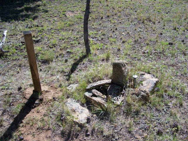
Nice photos. To add some metadata to your photos, the BLM monument marks the 1/4 cor. between Secs 23 & 24, Township 50 North, Range 7 East of the New Mexico Principal Meridian. Here is a link to the plat on the GLO Records web site for the 1989 survey. Please note the Lat/Long for the monument is in the NAD 27 Datum (North American Datum of 1927). This is the old horizontal datum and the one still used for USGS topo quadrangles. Dependent Resurvey and Subdivision of Sections 12 and 13 I attached a copy of the field notes for the above survey. The BLM Cadastral Surveyor found the original granite stone set by U.S. Dep. Surveyor F.B. Moore in 1880. The 1989 field notes state that a 15" diameter juniper bearing tree bears N15°E 87.5 lks. (57.7 ft.) The description for the corner is on pages 288 & 289 of Vol. 563 (pages 7 & 8 of the PDF file). The original granite stone was buried along side the aluminum post. The normal practice of BLM surveyors is to bury the original monument upside down and near the new monument. It is then referred to as a "memorial" to the true corner. [attachment=9754:Pages_from_COR0563.pdf] |
|
|
|
|
| Lo-Fi Version | Time is now: 28th April 2024 - 05:27 AM |