How Do I Avoid Claim Jumping?, Seeking the best techniques for prospecting "open" land |


 Colorado Prospector - Gem and mineral prospecting and mining forums > Prospecting, Mineral Collecting and Treasure Hunting Forums > Prospectors and Rockhounding Field Work
  |
How Do I Avoid Claim Jumping?, Seeking the best techniques for prospecting "open" land |
 Nov 13 2009, 10:28 AM Nov 13 2009, 10:28 AM
Post
#16
|
|
|
Diggin' In!  Group: Members Posts: 48 Joined: 23-July 09 Member No.: 6,960 |
I have been meaning to ask a similar question, but more towards how to verify private land. Or possibly water ownership(?). I know some areas are blm but cant tell where it ends from looking at geocom and lr2000. Maybe I'm using it wrong but i cant get it to show anything with actual ownership other than large scale blm and forest service. I had tried to make it to the blm office but after a 2 hour drive they were convieniently closed because of inclement weather.....lame.
|
 |
 
|
|
Nov 14 2009, 12:52 AM
Post
#17
|
|
 Master Mucker Group: Members Posts: 1,439 Joined: 22-February 04 Member No.: 98 |
In most places in Colorado the property bounds extend under water. So if you float, you're just fine. But set foot and it can be trespass.
-------------------- Today's socio-political climate is rock solid proof that Adam and Eve weren't prospectors.
If they were they'd have eaten the snake instead of the apple and we'd still be in heaven.... |
|
|
|
|
Nov 14 2009, 10:03 AM
Post
#18
|
|
|
Shovel Buster! Group: Members Posts: 112 Joined: 20-September 08 Member No.: 6,591 |
Rember that it is your responsibility to know the status of land. The private property does not have to have posted signs for you to be charged. You can be charged with misdemenor or felony. Check the county your interested in for a public tax map on the internet. Some counties have GIS sites that will give you parcel ownership information. This will show you where private land is. Unfortunately, not all counties have a GIS site.
|
|
|
|
|
Nov 14 2009, 12:48 PM
Post
#19
|
|
|
Diggin' In! Group: Members Posts: 48 Joined: 23-July 09 Member No.: 6,960 |
Thanks Rich if will give that a try. I should clarify that I am trying to find out who owns it because there is a walk-in public fishing access to the river but also appears to have cattle on it from time to time. So I need to figure out if it is private land that allows public access, and if thats the case find out if i could do some sluicing. Or if it is public land that is fenced because of a grazing lease on the land, in that case there shouldnt be a problem.
|
|
|
|
|
Nov 15 2009, 11:30 AM
Post
#20
|
|
 Master Mucker! Group: Admin Posts: 4,149 Joined: 7-October 03 From: Colorado Member No.: 3 |
Great input everyone!
 There are some other instances where I've seen fences and fishing access and or cattle. State lands, state wildlife areas can have leases for grazing and would have fishing access. But those are not public lands, they are owned by the state and run by state land trust board. Prospecting requires written permission and mining ops of any kind are only under leases and approved plans. Another situation might be open space, owned by that county or city etc and are not "public" land like NF or BLM. That city or county can make it's own rules to those lands, it's best to ask if you can't find the answer for open space. Shoot me a pm if you want me to check on some details for you, I may have already done some research in the past for the area your researching.  CP -------------------- CP-Owner/Administrator
www.ColoradoProspector.com IF YOU USE IT, THE GROUND PRODUCED IT! MINERS MAKE "IT" HAPPEN!! |
|
|
|
|
Jan 31 2010, 02:22 PM
Post
#21
|
|
|
Master Mucker! Group: Admin Posts: 4,149 Joined: 7-October 03 From: Colorado Member No.: 3 |
Hi everyone,
I've added a post to the Fight for Your rights section and thought it's information would be useful to those who read this thread as well. The new thread will help dispell many of the small scale mining myths one finds when trying to locate the proper information. Click over to the "Small Scale Mining, Truth vs. Myth" thread, maybe you'll find an answer you've been looking for too.  CP -------------------- CP-Owner/Administrator
www.ColoradoProspector.com IF YOU USE IT, THE GROUND PRODUCED IT! MINERS MAKE "IT" HAPPEN!! |
|
|
|
|
Jan 24 2012, 05:21 AM
Post
#22
|
|
|
Diggin' In! Group: Members Posts: 14 Joined: 14-January 12 Member No.: 38,139 |
Sounds like you need to do alot of research before you plan a prospecting trip. I need to start doing my research before my trip in May. I am planning on being around the Golden area and within a couple of counties west and southwest for sluicing. Thanks for all the valuable information, do not want to get in any trouble.
|
|
|
|
|
Jan 24 2012, 11:25 AM
Post
#23
|
|
 Rock Bar! Group: Members Posts: 426 Joined: 6-February 04 Member No.: 84 |
QUOTE (ColoradoProspector @ Nov 15 2009, 10:30 AM)  Another situation might be open space, owned by that county or city etc and are not "public" land like NF or BLM. That city or county can make it's own rules to those lands, it's best to ask if you can't find the answer for open space. CP This is the way it is in Lefthand Canyon north of Boulder. Buckingham Park belongs to Boulder Parks and they have recently gone to no prospecting period. Not even panning. My claim just happened to be right in the middle of the park lands. You've been there Dan. Leonard |
|
|
|
|
Jan 25 2012, 07:39 AM
Post
#24
|
|
|
russau Group: Members Posts: 2,841 Joined: 4-December 03 From: st.louis missouri Member No.: 43 |
to quickly find out wh owns land in a certain county, goto that countys courthouse/county seet(sp?) and ask for the county plat book for that county. they are about $20/30 each and you need to goto that county to get it. itll show current owners and property lines. ive been buying these while out looking for perperty to buy and its very helpfull!
|
|
|
|
|
Jan 25 2012, 10:20 AM
Post
#25
|
|
|
Rock Bar! Group: Members Posts: 426 Joined: 6-February 04 Member No.: 84 |
QUOTE (russau @ Jan 25 2012, 06:39 AM) to quickly find out wh owns land in a certain county, goto that countys courthouse/county seet(sp?) and ask for the county plat book for that county. they are about $20/30 each and you need to goto that county to get it. itll show current owners and property lines. ive been buying these while out looking for perperty to buy and its very helpfull! We usually go to the county asessor's office as they have large, detailed maps of private and public land. It lists owners names and addresses. If you take a digital camera, you can get pictures and then print the map out on your computer. Leonard |
|
|
|
|
Apr 1 2016, 07:08 AM
Post
#26
|
|
 Diggin' In! Group: Members Posts: 19 Joined: 31-March 16 From: Pensacola, Fl. Member No.: 122,605 |
I am also very interested in finding an answer to this problem. Surely there has got to be a GPS device that has topography maps that can be overlaid with claim maps from the BLM? I was told that claim maps from the BLM office could be put onto a Data Stick and possibly overlaid on a Garmin Topography map. Has anyone tried this using a Garmin eTrek30X?
-------------------- "I don't want excuses, I want results." Lifelong quote from my father.
Shawnee Man |
|
|
|
|
Apr 3 2016, 07:17 AM
Post
#27
|
|
|
Rock Bar! Group: Members Posts: 563 Joined: 13-June 15 From: South of Gunnison in Gold Basin, Saguache County Member No.: 120,659 |
The blm waives liability for the lr2000 even being correct. Good luck with that, if you can even figure out how to use it.
They told me all claims will be clearly marked and most will be fenced which I know isn't true. He insisted that claims are always clearly marked hehe. It's just one more fail to add to the list of many. They want to run it all but they aren't competent. The blm office in Gunnison can't make anything of the lr2000. It's like a foreign language to them. Worthless individuals. -------------------- Level 2 member -12/25/16
Referral code JL697 |
|
|
|
|
Jan 23 2017, 07:27 PM
Post
#28
|
|
 Shovel Buster! Group: Members Posts: 61 Joined: 3-January 17 From: Cleveland, OH Member No.: 124,868 |
Here's probably a newbie question, but is there a maximum size a claim can be for staking/marking?
|
|
|
|
|
Jan 23 2017, 09:08 PM
Post
#29
|
|
|
Rock Bar! Group: Members Posts: 563 Joined: 13-June 15 From: South of Gunnison in Gold Basin, Saguache County Member No.: 120,659 |
I'm a newbie also and I don't mean to spread misinformation so don't crucify me if I'm wrong. I'm in the process of learning all this as well and there is much to learn.
From what I gather an unpatented lode or placer claim is staked as 20 acres. I think that a single person can hold multiple claims, as many as ten maybe? Big placer operations might take up more than 20 acres for a huge deposit and lode claims would need room for mill sites and blacksmith shops and tailings and all that. Plus there were often placers down stream from the sources so they'd want that gold too, if it was rich enough. There is alot more to it than that but maybe it's a generic answer. Many here are claim holders and they are the real experts. -------------------- Level 2 member -12/25/16
Referral code JL697 |
|
|
|
|
Jan 25 2017, 06:54 PM
Post
#30
|
||
 Master Mucker! Group: Members Posts: 1,282 Joined: 13-January 14 From: Lakewood, Colorado Member No.: 116,305 |
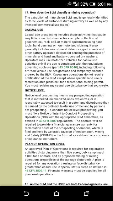
20 square acres in a rectangular strip and there is a limit on how much dirt you are allowed to process, There is also a limit on what KIND of machinery is allowed. No backhoes, skidsteers, etc. You are not allowed permanent structure and no major disruption of the land. So no strip mining, no housing, and X amount of material allowed. Screenshot from https://www.blm.gov/co/st/en/BLM_Programs/m...ining_faqs.html
This above information is based off of "casual collection claims." I'm personally clueless as far as getting into huge operations.
Attached thumbnail(s)
|
|
|
|
|
|
|
| Lo-Fi Version | Time is now: 17th July 2025 - 04:57 AM |