How Do I Avoid Claim Jumping?, Seeking the best techniques for prospecting "open" land |


 Colorado Prospector - Gem and mineral prospecting and mining forums > Prospecting, Mineral Collecting and Treasure Hunting Forums > Prospectors and Rockhounding Field Work
How Do I Avoid Claim Jumping?, Seeking the best techniques for prospecting "open" land |
 Jul 18 2009, 04:11 PM Jul 18 2009, 04:11 PM
Post
#1
|
|
|
Diggin' In!  Group: Members Posts: 11 Joined: 4-December 08 Member No.: 6,821 |
Hi everybody.
 HELP! What's the easiest and most accurate way to view or to plot active mining claims? My goal is to preview claims from a birds-eye-view on a map so that while I'm prospecting I will not trespass on mineral rights. Geocommunicator.com is not accurate, title master platts don't show un-patented claims and LR2000 provides serial numbers that when entered into Geocommunicator.com gives all coordinates (each corner of the claim) in "decimal" format (not degree, minutes and seconds). The area I'm prospecting shows a claim density of 50 - 100 claims and I KNOW there has to be an easier way to identify/view claim bounderies without me: 1) Converting decimal coordinated to degrees, minutes and seconds (for EACH corner of EACH claim). 2) Ploting those coordinates on a topographical map. In other words... What's the best technique for prospecting while at the same time avoid trespassing? THANKS! |
 |
 
|
 |
|
Jul 18 2009, 08:50 PM
Post
#2
|
|
 Shovel Buster! Group: Members Posts: 64 Joined: 3-August 07 From: Dodge City, KS. Member No.: 1,581 |
QUOTE (English @ Jul 18 2009, 04:11 PM)  Hi everybody. HELP! What's the easiest and most accurate way to view or to plot active mining claims? My goal is to preview claims from a birds-eye-view on a map so that while I'm prospecting I will not trespass on mineral rights. Geocommunicator.com is not accurate, title master platts don't show un-patented claims and LR2000 provides serial numbers that when entered into Geocommunicator.com gives all coordinates (each corner of the claim) in "decimal" format (not degree, minutes and seconds). The area I'm prospecting shows a claim density of 50 - 100 claims and I KNOW there has to be an easier way to identify/view claim bounderies without me: 1) Converting decimal coordinated to degrees, minutes and seconds (for EACH corner of EACH claim). 2) Ploting those coordinates on a topographical map. In other words... What's the best technique for prospecting while at the same time avoid trespassing? THANKS! Hi English, I'm going to be of no help to ya! I get completely lost in all the areas of finding and staking a claim. That's one reason I joined up and paid my membership dues. Easier for me that way. I know alot of people want their own claim, and I applaud them for the work, time, energy and expense it takes to get it done. Maybe someone else can jump in and help you out. Best of luck to ya! -------------------- The impersonal hand of government can never replace the helping hand of a neighbor. -Hubert H. Humphrey
|
|
|
|
|
Jul 19 2009, 08:08 AM
Post
#3
|
|
|
Shovel Buster! Group: Members Posts: 171 Joined: 30-December 07 From: albuquerque n.m. Member No.: 3,582 |
 Mike how was your trip?? Mike how was your trip??
|
|
|
|
|
Jul 19 2009, 10:41 AM
Post
#4
|
|
|
Shovel Buster! Group: Members Posts: 64 Joined: 3-August 07 From: Dodge City, KS. Member No.: 1,581 |
QUOTE (nm jack @ Jul 19 2009, 09:08 AM) Mike how was your trip??GREAT!! I made a post about it in the members protected forum. -------------------- The impersonal hand of government can never replace the helping hand of a neighbor. -Hubert H. Humphrey
|
|
|
|
|
Jul 20 2009, 04:29 PM
Post
#5
|
|
 Master Mucker! Group: Admin Posts: 4,149 Joined: 7-October 03 From: Colorado Member No.: 3 |
QUOTE (English @ Jul 18 2009, 04:11 PM) Hi everybody. HELP! What's the easiest and most accurate way to view or to plot active mining claims? My goal is to preview claims from a birds-eye-view on a map so that while I'm prospecting I will not trespass on mineral rights. Geocommunicator.com is not accurate, title master platts don't show un-patented claims and LR2000 provides serial numbers that when entered into Geocommunicator.com gives all coordinates (each corner of the claim) in "decimal" format (not degree, minutes and seconds). The area I'm prospecting shows a claim density of 50 - 100 claims and I KNOW there has to be an easier way to identify/view claim bounderies without me: 1) Converting decimal coordinated to degrees, minutes and seconds (for EACH corner of EACH claim). 2) Ploting those coordinates on a topographical map. In other words... What's the best technique for prospecting while at the same time avoid trespassing? THANKS! Hi English, Great question you've posted, and very important as well! Whether one wishes to find a spot to claim or just a fresh place to prospect without claim jumping someone elses.  For the benefit of others who might be wondering this as well...lets back up to the very begining of the research and why.  After one's found an area of geologic interest to them, ie.... gold, silver, diamonds, or lode deposit veins, placers etc. Then the next question is.... "Where can I look for deposits now?" We of course do not wish to claim jump on anyone elses claims and we may or may not be looking to file claims in the future. So, how do we find these "spots" without the claims? At this point if we don't want to file claims or if we do......the next step still applies to both, we need to find an "open area" without those claims to even prospect. Now on the scale of 50-100 claims this would seem like a huge task but that sounds like a larger area of research English has in mind here and he may have been working on his research for sometime. For those just starting out, this may only be one or two specific spots you've been around and wondered about. There are several sources of information needed to find the "land status" of each in question. IE is it BLM, NF or privately owned land. Once you've found the right land status maps to give you a general idea then of course you will need more detail on each. Again, coming from several different sources at federal and local offices to check and reverify all findings from each too. Along with this public information, there are many, many, many laws/codes to learn along the way for each step begining with our right to prospect and finding new deposits all the way up to large scale mining operations. With new ammendments being continually added every year. The long and short of it is.....there is no one answer for all research.   There are so many factors that could play into a specific piece. The county offices and BLM will have any location claims recorded on record which can be checked prior to prospecting to make sure there are no claims. Try choosing the best locals in your prospects and plan a day of research at that counties offices prior to prospecting, check out the best ones (geologically of course) and go from there. There are so many factors that could play into a specific piece. The county offices and BLM will have any location claims recorded on record which can be checked prior to prospecting to make sure there are no claims. Try choosing the best locals in your prospects and plan a day of research at that counties offices prior to prospecting, check out the best ones (geologically of course) and go from there.There isn't an accurate way that I know of to plot that many claims at once with any single source of information either....just have to plot through them very diligently one at a time with the research. Of course joining the ColoradoProspector club would be a great advantage, as we all try to help each other learn specifics about that very type of research question as well as many others.......  In reality, this information (and the lack of it accurately on the net) is exactly why the CP club was started. If you ever attend any club outings, we also concentrate discussions during the events toward these topics too. Once you've got the research completed and all is good.......GET ON OUT THERE AND MAKE YOUR DISCOVERIES! GOOD LUCK! CP -------------------- CP-Owner/Administrator
www.ColoradoProspector.com IF YOU USE IT, THE GROUND PRODUCED IT! MINERS MAKE "IT" HAPPEN!! |
|
|
|
|
Jul 20 2009, 11:03 PM
Post
#6
|
|
|
Diggin' In! Group: Members Posts: 11 Joined: 4-December 08 Member No.: 6,821 |
Thanks CP!
Your answer was helpful. For everyone else... I'll continue checking this post for any other suggestions. Thanks again. |
|
|
|
|
Aug 8 2009, 01:56 PM
Post
#7
|
|
|
Shovel Buster! Group: Members Posts: 64 Joined: 3-August 07 From: Dodge City, KS. Member No.: 1,581 |
QUOTE (ColoradoProspector @ Jul 20 2009, 05:29 PM) ....The long and short of it is.....there is no one answer for all research. There are so many factors that could play into a specific piece. The county offices and BLM will have any location claims recorded on record which can be checked prior to prospecting to make sure there are no claims. CP, When I check with them, what info. do I need to supply them...the GPS cooridnates? Well...I found this... "Rather than looking randomly through the records for lands open to location, it is better to restrict your search to a specific area of interest. Topographic maps of the area (published by the U.S. Geological Survey) provide the legal description (meridian, township, range, section) of such lands. Visit the local BLM field office or the BLM State Office and check maps, the BLM Master Title Plats, mining claim records, and files. Ultimately, it is your responsibility to determine if there are prior existing mining claims on the ground."Living in Kansas makes this process abit more time consuming...One more reason I became a member of CP.
-------------------- The impersonal hand of government can never replace the helping hand of a neighbor. -Hubert H. Humphrey
|
|
|
|
|
Aug 9 2009, 06:35 AM
Post
#8
|
|
|
russau Group: Members Posts: 2,841 Joined: 4-December 03 From: st.louis missouri Member No.: 43 |
AHMEN!
|
|
|
|
|
Aug 9 2009, 09:35 AM
Post
#9
|
|
|
Diggin' In! Group: Members Posts: 11 Joined: 4-December 08 Member No.: 6,821 |
Mike B.
Good advice. But how would that address my issue with claim boundaries? To avoid claim jumping one needs at least 4 coordinate numbers to know where the boundaries are. Most mine information sources I've found give only 1 coordinate number. Geocommunicator.com gives 4 numbers but again... they're in decimal form and need to be converted to degrees, minutes and second before they can be plotted on a topographical map. At this point I'm resigned to converting all 4 numbers to each mine in my search area that has, according to Geocommunicator.com, a mine claim density of 50-100 and THEN carefully plot each point on a topo map. I want to know not only where the mines are (X's on a map) but where the mines boundaries are too. I sure don't want to be wasting valuable time out in the field searching around for claim markers. I'm still seeking an easier/more efficient method to know/see on a topographical map mine claim boundaries. Any other suggestions are welcomed. Thanks! |
|
|
|
|
Aug 22 2009, 04:10 PM
Post
#10
|
|
|
Master Mucker! Group: Admin Posts: 4,149 Joined: 7-October 03 From: Colorado Member No.: 3 |
You are very welcome English, I'm happy to help if I can.
Thanks Mike and Russ!  That's what the CP club is about, helping club members learn these steps and processes for their own use anytime needed. That's what the CP club is about, helping club members learn these steps and processes for their own use anytime needed. For more details and pin downs for location claims, I think it's gonna' be a county office visit or online data if available for the county of interest. You'll need to either search by area (ie, sections etc) or by claim names/numbers if you've got them. On the patented claims (y's printed on maps) that will also be at the county if needed (different office), or you could look up the old surveys through BLM for them. As I've said previously in other threads though, the geocom system has some troubles with it's attempt to overlay claim info onto digital map representations.....it's just not as accurate as one would like it to be and can cause unneeded confusion......by showing claims oversized or over someone elses. Careful using it. CP -------------------- CP-Owner/Administrator
www.ColoradoProspector.com IF YOU USE IT, THE GROUND PRODUCED IT! MINERS MAKE "IT" HAPPEN!! |
|
|
|
|
Aug 25 2009, 03:40 PM
Post
#11
|
|
 Shovel Buster! Group: Members Posts: 78 Joined: 26-November 08 From: outside atlanta Member No.: 6,819 |
That is why i think claim boundry markers and stakes should be mandatory and enforced. With the best hand-held GPS you can still be off many feet..there is no sure fire way to tell exactly except for a demarcation line drawn between two points..I brought this point up in the antro thread..just my thoughts
-------------------- Amethystguy cometh and the amethystguy taketh away
|
|
|
|
|
Aug 25 2009, 05:08 PM
Post
#12
|
|
|
Master Mucker! Group: Admin Posts: 4,149 Joined: 7-October 03 From: Colorado Member No.: 3 |
Corner markers are required for all location claims and survey markers/monuments can not be removed once placed. In fact if someone moves a survey monument that isn't a certified surveyor working that ground, it's a felony to move one.
There is one sure fire way and the only way to know for sure where you are.........beat the bush and find the markers, they are out there or should be unless it was one of those paper filed location claims. If that's the case then the so called claim owner never visited the ground but only filed the papers. Not a claim owner since the discovery was never made.  In that case you won't find any markers. In that case you won't find any markers.In the field these markers maybe survey markers from patented lands or surveyed location claims. And corner markers (claim owner erected) for location claims, although some get knocked down, rarely do the scoundrels scout out all corners. Location claim corners might be a stack of stones, a post (metal, wood, pvc), or a marked stone say on a large rock at the corner. With the proper research (alot of research) and documents in the field for refering to, one can find exactly where the "corners" are.   I've trudged through the shrubs and rocks alot doing this very thing. CP -------------------- CP-Owner/Administrator
www.ColoradoProspector.com IF YOU USE IT, THE GROUND PRODUCED IT! MINERS MAKE "IT" HAPPEN!! |
|
|
|
|
Aug 25 2009, 06:50 PM
Post
#13
|
|
 Rock Bar! Group: Members Posts: 613 Joined: 16-October 08 From: Central Colorado Member No.: 6,813 |
I am happy to see this conversation take place. As a mining claim owner, I have seen far too many "claim jumpers". It is encouraging to see folks take an interest in avoiding a mineral trespass. On the other hand, those folks that are researching the public records in an effort to find the location of a valuable claim... and then make a plan to go there...and then steal from the owner...will get what they deserve!
Thanks CP for providing a forum that allows for education of those hardy soles willing to take up prospecting.… ASTROBLEME -------------------- Annual Dues Paying Member Since 2008
Tonko Mining Company "Some day this crater is going to be a greatly talked about place, and if the above credit is due, as is certainly the case, I would like to have it generally known for the sake of the children." Daniel Moreau Barringer 2/1/1912 in a letter about the Barringer Meteorite Crater, Arizona USA |
|
|
|
|
Aug 30 2009, 09:41 PM
Post
#14
|
|
 Moderator Group: Members Posts: 4,459 Joined: 25-August 09 From: way on up thar Member No.: 6,983 |
I find this to be a useful link for Colorado but it's still a lot of info to sift through: Colorado BLM Claim Info
-------------------- /l ,[____], l---L-OlllllllO- ()_) ()_)--o-)_) BLACK SANDS MATTER! Very Happy CP Lifetime Member CP CORE TEAM Referral Code CE213 |
|
|
|
|
Nov 12 2009, 09:00 AM
Post
#15
|
|
|
Master Mucker! Group: Admin Posts: 4,149 Joined: 7-October 03 From: Colorado Member No.: 3 |
Thank you Astrobleme, it's our pleasure to have this type of discussion here as we are all in this together and we all need to know this type of information as prospectors in the field.
Good link Swizz for sure! Yep it's alot of information and well worth the efforts to sift through in the long run. Knowledge is power in prospecting / mining. This thread will continue to help those who are really interested for a long time to come, good input everyone! -------------------- CP-Owner/Administrator
www.ColoradoProspector.com IF YOU USE IT, THE GROUND PRODUCED IT! MINERS MAKE "IT" HAPPEN!! |
|
|
|
|
Nov 13 2009, 10:28 AM
Post
#16
|
|
|
Diggin' In! Group: Members Posts: 48 Joined: 23-July 09 Member No.: 6,960 |
I have been meaning to ask a similar question, but more towards how to verify private land. Or possibly water ownership(?). I know some areas are blm but cant tell where it ends from looking at geocom and lr2000. Maybe I'm using it wrong but i cant get it to show anything with actual ownership other than large scale blm and forest service. I had tried to make it to the blm office but after a 2 hour drive they were convieniently closed because of inclement weather.....lame.
|
|
|
|
|
Nov 14 2009, 12:52 AM
Post
#17
|
|
 Master Mucker Group: Members Posts: 1,439 Joined: 22-February 04 Member No.: 98 |
In most places in Colorado the property bounds extend under water. So if you float, you're just fine. But set foot and it can be trespass.
-------------------- Today's socio-political climate is rock solid proof that Adam and Eve weren't prospectors.
If they were they'd have eaten the snake instead of the apple and we'd still be in heaven.... |
|
|
|
|
Nov 14 2009, 10:03 AM
Post
#18
|
|
|
Shovel Buster! Group: Members Posts: 112 Joined: 20-September 08 Member No.: 6,591 |
Rember that it is your responsibility to know the status of land. The private property does not have to have posted signs for you to be charged. You can be charged with misdemenor or felony. Check the county your interested in for a public tax map on the internet. Some counties have GIS sites that will give you parcel ownership information. This will show you where private land is. Unfortunately, not all counties have a GIS site.
|
|
|
|
|
Nov 14 2009, 12:48 PM
Post
#19
|
|
|
Diggin' In! Group: Members Posts: 48 Joined: 23-July 09 Member No.: 6,960 |
Thanks Rich if will give that a try. I should clarify that I am trying to find out who owns it because there is a walk-in public fishing access to the river but also appears to have cattle on it from time to time. So I need to figure out if it is private land that allows public access, and if thats the case find out if i could do some sluicing. Or if it is public land that is fenced because of a grazing lease on the land, in that case there shouldnt be a problem.
|
|
|
|
|
Nov 15 2009, 11:30 AM
Post
#20
|
|
|
Master Mucker! Group: Admin Posts: 4,149 Joined: 7-October 03 From: Colorado Member No.: 3 |
Great input everyone!
There are some other instances where I've seen fences and fishing access and or cattle. State lands, state wildlife areas can have leases for grazing and would have fishing access. But those are not public lands, they are owned by the state and run by state land trust board. Prospecting requires written permission and mining ops of any kind are only under leases and approved plans. Another situation might be open space, owned by that county or city etc and are not "public" land like NF or BLM. That city or county can make it's own rules to those lands, it's best to ask if you can't find the answer for open space. Shoot me a pm if you want me to check on some details for you, I may have already done some research in the past for the area your researching. CP -------------------- CP-Owner/Administrator
www.ColoradoProspector.com IF YOU USE IT, THE GROUND PRODUCED IT! MINERS MAKE "IT" HAPPEN!! |
|
|
|
|
Jan 31 2010, 02:22 PM
Post
#21
|
|
|
Master Mucker! Group: Admin Posts: 4,149 Joined: 7-October 03 From: Colorado Member No.: 3 |
Hi everyone,
I've added a post to the Fight for Your rights section and thought it's information would be useful to those who read this thread as well. The new thread will help dispell many of the small scale mining myths one finds when trying to locate the proper information. Click over to the "Small Scale Mining, Truth vs. Myth" thread, maybe you'll find an answer you've been looking for too. CP -------------------- CP-Owner/Administrator
www.ColoradoProspector.com IF YOU USE IT, THE GROUND PRODUCED IT! MINERS MAKE "IT" HAPPEN!! |
|
|
|
|
Jan 24 2012, 05:21 AM
Post
#22
|
|
|
Diggin' In! Group: Members Posts: 14 Joined: 14-January 12 Member No.: 38,139 |
Sounds like you need to do alot of research before you plan a prospecting trip. I need to start doing my research before my trip in May. I am planning on being around the Golden area and within a couple of counties west and southwest for sluicing. Thanks for all the valuable information, do not want to get in any trouble.
|
|
|
|
|
Jan 24 2012, 11:25 AM
Post
#23
|
|
 Rock Bar! Group: Members Posts: 426 Joined: 6-February 04 Member No.: 84 |
QUOTE (ColoradoProspector @ Nov 15 2009, 10:30 AM) Another situation might be open space, owned by that county or city etc and are not "public" land like NF or BLM. That city or county can make it's own rules to those lands, it's best to ask if you can't find the answer for open space. CP This is the way it is in Lefthand Canyon north of Boulder. Buckingham Park belongs to Boulder Parks and they have recently gone to no prospecting period. Not even panning. My claim just happened to be right in the middle of the park lands. You've been there Dan. Leonard |
|
|
|
|
Jan 25 2012, 07:39 AM
Post
#24
|
|
|
russau Group: Members Posts: 2,841 Joined: 4-December 03 From: st.louis missouri Member No.: 43 |
to quickly find out wh owns land in a certain county, goto that countys courthouse/county seet(sp?) and ask for the county plat book for that county. they are about $20/30 each and you need to goto that county to get it. itll show current owners and property lines. ive been buying these while out looking for perperty to buy and its very helpfull!
|
|
|
|
|
Jan 25 2012, 10:20 AM
Post
#25
|
|
|
Rock Bar! Group: Members Posts: 426 Joined: 6-February 04 Member No.: 84 |
QUOTE (russau @ Jan 25 2012, 06:39 AM) to quickly find out wh owns land in a certain county, goto that countys courthouse/county seet(sp?) and ask for the county plat book for that county. they are about $20/30 each and you need to goto that county to get it. itll show current owners and property lines. ive been buying these while out looking for perperty to buy and its very helpfull! We usually go to the county asessor's office as they have large, detailed maps of private and public land. It lists owners names and addresses. If you take a digital camera, you can get pictures and then print the map out on your computer. Leonard |
|
|
|
|
Apr 1 2016, 07:08 AM
Post
#26
|
|
 Diggin' In! Group: Members Posts: 19 Joined: 31-March 16 From: Pensacola, Fl. Member No.: 122,605 |
I am also very interested in finding an answer to this problem. Surely there has got to be a GPS device that has topography maps that can be overlaid with claim maps from the BLM? I was told that claim maps from the BLM office could be put onto a Data Stick and possibly overlaid on a Garmin Topography map. Has anyone tried this using a Garmin eTrek30X?
-------------------- "I don't want excuses, I want results." Lifelong quote from my father.
Shawnee Man |
|
|
|
|
Apr 3 2016, 07:17 AM
Post
#27
|
|
|
Rock Bar! Group: Members Posts: 563 Joined: 13-June 15 From: South of Gunnison in Gold Basin, Saguache County Member No.: 120,659 |
The blm waives liability for the lr2000 even being correct. Good luck with that, if you can even figure out how to use it.
They told me all claims will be clearly marked and most will be fenced which I know isn't true. He insisted that claims are always clearly marked hehe. It's just one more fail to add to the list of many. They want to run it all but they aren't competent. The blm office in Gunnison can't make anything of the lr2000. It's like a foreign language to them. Worthless individuals. -------------------- Level 2 member -12/25/16
Referral code JL697 |
|
|
|
|
Jan 23 2017, 07:27 PM
Post
#28
|
|
 Shovel Buster! Group: Members Posts: 61 Joined: 3-January 17 From: Cleveland, OH Member No.: 124,868 |
Here's probably a newbie question, but is there a maximum size a claim can be for staking/marking?
|
|
|
|
|
Jan 23 2017, 09:08 PM
Post
#29
|
|
|
Rock Bar! Group: Members Posts: 563 Joined: 13-June 15 From: South of Gunnison in Gold Basin, Saguache County Member No.: 120,659 |
I'm a newbie also and I don't mean to spread misinformation so don't crucify me if I'm wrong. I'm in the process of learning all this as well and there is much to learn.
From what I gather an unpatented lode or placer claim is staked as 20 acres. I think that a single person can hold multiple claims, as many as ten maybe? Big placer operations might take up more than 20 acres for a huge deposit and lode claims would need room for mill sites and blacksmith shops and tailings and all that. Plus there were often placers down stream from the sources so they'd want that gold too, if it was rich enough. There is alot more to it than that but maybe it's a generic answer. Many here are claim holders and they are the real experts. -------------------- Level 2 member -12/25/16
Referral code JL697 |
|
|
|
|
Jan 25 2017, 06:54 PM
Post
#30
|
||
 Master Mucker! Group: Members Posts: 1,282 Joined: 13-January 14 From: Lakewood, Colorado Member No.: 116,305 |
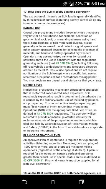
20 square acres in a rectangular strip and there is a limit on how much dirt you are allowed to process, There is also a limit on what KIND of machinery is allowed. No backhoes, skidsteers, etc. You are not allowed permanent structure and no major disruption of the land. So no strip mining, no housing, and X amount of material allowed. Screenshot from https://www.blm.gov/co/st/en/BLM_Programs/m...ining_faqs.html
This above information is based off of "casual collection claims." I'm personally clueless as far as getting into huge operations.
Attached thumbnail(s)
|
|
|
|
|
|
|
Jan 25 2017, 09:34 PM
Post
#31
|
|
|
Shovel Buster! Group: Members Posts: 61 Joined: 3-January 17 From: Cleveland, OH Member No.: 124,868 |
I have no intention of trying to file a claim as I live in Ohio, but was curious on how big claims could be. Only going to be able to make it to Colorado for a few days when the kids get out of school. I am still trying to figure out the research for where claims are.
|
|
|
|
|
Jan 26 2017, 09:42 AM
Post
#32
|
|
|
Rock Bar! Group: Members Posts: 563 Joined: 13-June 15 From: South of Gunnison in Gold Basin, Saguache County Member No.: 120,659 |
I picked up surface management maps at the blm office yesterday so I can begin my lr2000 studies haha. It's all been french to me but I think I'm getting it after seeing the maps. It makes more sense, now if I can enter the data correctly I'll be doing something!
-------------------- Level 2 member -12/25/16
Referral code JL697 |
|
|
|
|
Jan 26 2017, 06:58 PM
Post
#33
|
|
|
Rock Bar! Group: Members Posts: 563 Joined: 13-June 15 From: South of Gunnison in Gold Basin, Saguache County Member No.: 120,659 |
Mineral trespass in Colorado is a class c felony. Ouch!
-------------------- Level 2 member -12/25/16
Referral code JL697 |
|
|
|
|
Jan 26 2017, 09:45 PM
Post
#34
|
|
|
Shovel Buster! Group: Members Posts: 61 Joined: 3-January 17 From: Cleveland, OH Member No.: 124,868 |
Not going to lie, it scares the crap out of me and is very intimidating!
|
|
|
|
|
Jan 27 2017, 11:59 AM
Post
#35
|
|
 Rock Bar! Group: Members Posts: 875 Joined: 25-July 14 From: Westminster, CO Member No.: 117,949 |
If you're looking for areas open to mineral exploration, you'll need the mineral management maps. They look the same, but mineral maps contain additional markings showing where you can explore for minerals, including if there are restrictions against types.
From their page: https://www.blm.gov/co/st/en/BLM_Resources/...m/map_info.html QUOTE A variation, the Surface and Mineral Management Map, depicts the location and nature of federally owned mineral rights in addition to surface management information.
-------------------- Lifetime Member
opera non verba "All courses of action are risky, so prudence is not in avoiding danger (it's impossible), but calculating risk and acting decisively. Make mistakes of ambition and not mistakes of sloth. Develop the strength to do bold things, not the strength to suffer." ~Niccolò Machiavelli Ref Code: EM448 |
|
|
|
|
Jan 27 2017, 01:05 PM
Post
#36
|
|
|
Moderator Group: Members Posts: 4,459 Joined: 25-August 09 From: way on up thar Member No.: 6,983 |
Hmmm. I don't mean to be a Debbie Downer but I'm not familiar with those maps and have a few concerns regarding their use for confirming open land to mineral prospect, at least not using this exclusively. They apparently have some useful land status information but they can't possibly show up to the minute land status in regard to claim ownerships, don't show claim boundaries, and I'm confused as to the terminology "depicts the location and nature of federally owned mineral rights". Are they referring to 'mineral claims' in that statement? I am assuming so and not sure that they can display accurate claim boundaries, which is important. Otherwise it would seem that it's a printed version of what can be obtained on geocom. Am I wrong?
-------------------- /l ,[____], l---L-OlllllllO- ()_) ()_)--o-)_) BLACK SANDS MATTER! Very Happy CP Lifetime Member CP CORE TEAM Referral Code CE213 |
|
|
|
|
Jan 27 2017, 02:30 PM
Post
#37
|
|
 Master Mucker! Group: Members Posts: 2,430 Joined: 6-June 13 From: Falcon, CO Member No.: 82,915 |
QUOTE (swizz @ Jan 27 2017, 12:05 PM) Hmmm. I don't mean to be a Debbie Downer but I'm not familiar with those maps and have a few concerns regarding their use for confirming open land to mineral prospect, at least not using this exclusively. They apparently have some useful land status information but they can't possibly show up to the minute land status in regard to claim ownerships, don't show claim boundaries, and I'm confused as to the terminology "depicts the location and nature of federally owned mineral rights". Are they referring to 'mineral claims' in that statement? I am assuming so and not sure that they can display accurate claim boundaries, which is important. Otherwise it would seem that it's a printed version of what can be obtained on geocom. Am I wrong? I think by "areas open to mineral exploration" he just meant it shows area where mineral exploration hasn't been withdrawn. (pointing out the difference between the surface management and mineral management maps) -------------------- Find Colorado Prospector on Facebook: https://www.facebook.com/groups/170314493176558
CP Lifetime Member |
|
|
|
|
Jan 27 2017, 03:12 PM
Post
#38
|
|
|
Moderator Group: Members Posts: 4,459 Joined: 25-August 09 From: way on up thar Member No.: 6,983 |
ah got it, thank you.
-------------------- /l ,[____], l---L-OlllllllO- ()_) ()_)--o-)_) BLACK SANDS MATTER! Very Happy CP Lifetime Member CP CORE TEAM Referral Code CE213 |
|
|
|
|
Jan 27 2017, 07:01 PM
Post
#39
|
|
|
Shovel Buster! Group: Members Posts: 61 Joined: 3-January 17 From: Cleveland, OH Member No.: 124,868 |
So those maps would show where public prospecting could happen?
|
|
|
|
|
Jan 27 2017, 08:00 PM
Post
#40
|
|
|
Master Mucker! Group: Members Posts: 2,430 Joined: 6-June 13 From: Falcon, CO Member No.: 82,915 |
QUOTE (Greenday401 @ Jan 27 2017, 06:01 PM) So those maps would show where public prospecting could happen? All they tell you is the public land open for mineral exploration, not the actual status of the land (claims) -------------------- Find Colorado Prospector on Facebook: https://www.facebook.com/groups/170314493176558
CP Lifetime Member |
|
|
|
|
Jan 27 2017, 09:26 PM
Post
#41
|
|
|
Rock Bar! Group: Members Posts: 875 Joined: 25-July 14 From: Westminster, CO Member No.: 117,949 |
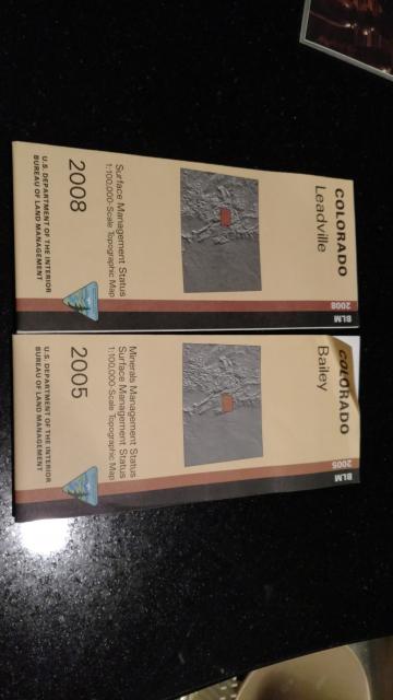
Hell no those maps don't have up to the minute info; you'd be lucky to have up to the decade for some! I just looked, and 2 of mine (ordered last year) are from 2005. This is the course look, showing what general areas one can start digging further with research, LR2000, your local office and ultimately the shovel.
-------------------- Lifetime Member
opera non verba "All courses of action are risky, so prudence is not in avoiding danger (it's impossible), but calculating risk and acting decisively. Make mistakes of ambition and not mistakes of sloth. Develop the strength to do bold things, not the strength to suffer." ~Niccolò Machiavelli Ref Code: EM448 |
|
|
|
|
Jan 27 2017, 09:37 PM
Post
#42
|
||
|
Rock Bar! Group: Members Posts: 875 Joined: 25-July 14 From: Westminster, CO Member No.: 117,949 |
Towards the bottom you can see Minerals...vs Surface Management...
-------------------- Lifetime Member
opera non verba "All courses of action are risky, so prudence is not in avoiding danger (it's impossible), but calculating risk and acting decisively. Make mistakes of ambition and not mistakes of sloth. Develop the strength to do bold things, not the strength to suffer." ~Niccolò Machiavelli Ref Code: EM448 |
|
|
|
|
|
|
Jan 27 2017, 11:46 PM
Post
#43
|
|
|
Rock Bar! Group: Members Posts: 563 Joined: 13-June 15 From: South of Gunnison in Gold Basin, Saguache County Member No.: 120,659 |
As long as it's nf or blm is should be open right? Especially if there are other claims around. Wilderness and Natl parks and monuments and all that are clearly marked on my other maps.
-------------------- Level 2 member -12/25/16
Referral code JL697 |
|
|
|
|
Jan 28 2017, 10:05 AM
Post
#44
|
|
|
Rock Bar! Group: Members Posts: 875 Joined: 25-July 14 From: Westminster, CO Member No.: 117,949 |
That's a decent rule of thumb, but it's not always true. For instance if you have the Estes mineral map, you can see Fairview peak and west of North Sheep Mountain aren't open to exploration (no vertical line markings), despite being managed by the FS with lands open to exploration around them both. Keep in mind, this map is also from 2010; if I were interested in those two areas, I would research further to see what the specific situation is there for mining.
-------------------- Lifetime Member
opera non verba "All courses of action are risky, so prudence is not in avoiding danger (it's impossible), but calculating risk and acting decisively. Make mistakes of ambition and not mistakes of sloth. Develop the strength to do bold things, not the strength to suffer." ~Niccolò Machiavelli Ref Code: EM448 |
|
|
|
|
Jan 28 2017, 11:00 AM
Post
#45
|
|
|
Rock Bar! Group: Members Posts: 563 Joined: 13-June 15 From: South of Gunnison in Gold Basin, Saguache County Member No.: 120,659 |
We hiked in to fairview lake and mountain last summer a few times and I camped there too. It's a thick forest up there and a good hike up. I found some gold up there at one of the confluences down from the lake but need to do more testing. There are also terminal moraines just down from the lake that need tested but my wife almost poked her eye out with a tree branch so I didn't really get time. The parallel gulches have the same moraines. There are a few faults up there that interest me and I'll be back up there this summer as well as other places in that area to look at. It takes so much time to do this work but it's my favorite part of it. There is probably a vein up there still.
Sheep mtn I believe is in fossil ridge wilderness but fairview is in the wilderness recreation area. Wilderness recreation isn't closed to claims but the wilderness area itself is. They can both be prospected for gold but limited opportunity to stake a claim. It's fine to dig and prospect either way. If you're ever interested in spending time up there I'd go with you. It's a big area but Ive learned some of it. There's an old cabin out there we found last summer in a gulch nearby. The tin cans we found there were all the old pre1887 style with the cap and seal solder work and the soldered side seam. I'd like to detect it sometime when I'm up there. I will be spending all my free time up there this summer. We saw 6 moose up there in one day. -------------------- Level 2 member -12/25/16
Referral code JL697 |
|
|
|
|
Jan 28 2017, 07:37 PM
Post
#46
|
|
 Rock Bar! Group: Members Posts: 898 Joined: 9-January 14 From: Denver, CO Member No.: 116,265 |
QUOTE (Greenday401 @ Jan 23 2017, 06:27 PM) Here's probably a newbie question, but is there a maximum size a claim can be for staking/marking? Lode claim maximum is 1,500 feet long and 600 feet wide (20.66 acres) Placer claim 20 acres per person. Up to 8 people can sign on to one 160 acre placer claim. Be careful with the Surface and or Mineral maps cause they can be outdated, inaccurate and confusing. BLM is discontinuing them likely for that reason but the surface only maps will still be available. Club Members have good follow up information in the protected forums. -------------------- |
|
|
|
|
Jan 28 2017, 08:06 PM
Post
#47
|
|
|
Rock Bar! Group: Members Posts: 563 Joined: 13-June 15 From: South of Gunnison in Gold Basin, Saguache County Member No.: 120,659 |
Edited...Sorry I misunderstood.
-------------------- Level 2 member -12/25/16
Referral code JL697 |
|
|
|
|
Jan 28 2017, 08:59 PM
Post
#48
|
|
 Master Mucker! Group: Members Posts: 1,301 Joined: 17-February 12 From: Central CO Member No.: 41,357 |
QUOTE (johnnybravo300 @ Jan 28 2017, 07:06 PM) I'm confused on how a map can be out dated. I thought the mrts system was implemented after 1872 and has remain unchanged? What exactly is not accurate. I just bought these two maps and haven't written on them yet or cut them. Typically, maps come out several months after they are printed, which may be once a year, or several years. -------------------- Caveman
Aulus Livius Maximus World Traveler, 7 Continent Walker LEVEL 3 LIFETIME MEMBER Referral Code: SE2104 |
|
|
|
|
Jan 30 2017, 11:37 AM
Post
#49
|
|
|
Rock Bar! Group: Members Posts: 875 Joined: 25-July 14 From: Westminster, CO Member No.: 117,949 |
QUOTE (MikeS @ Jan 28 2017, 06:37 PM) Be careful with the Surface and or Mineral maps cause they can be outdated, inaccurate and confusing. BLM is discontinuing them likely for that reason but the surface only maps will still be available. Club Members have good follow up information in the protected forums. Where did you see they are discontinuing them? I could see them going online, but they don't have Avenza released for Colorado yet. -------------------- Lifetime Member
opera non verba "All courses of action are risky, so prudence is not in avoiding danger (it's impossible), but calculating risk and acting decisively. Make mistakes of ambition and not mistakes of sloth. Develop the strength to do bold things, not the strength to suffer." ~Niccolò Machiavelli Ref Code: EM448 |
|
|
|
|
Jan 30 2017, 01:29 PM
Post
#50
|
|
|
Rock Bar! Group: Members Posts: 898 Joined: 9-January 14 From: Denver, CO Member No.: 116,265 |
QUOTE (EMac @ Jan 30 2017, 10:37 AM) Where did you see they are discontinuing them? I could see them going online, but they don't have Avenza released for Colorado yet. Last time Dave was at the BLM office they said they were discontinuing the mineral maps and they were already out of some of the ones we wanted. They are still selling the ones they have printed but say they they are phasing them out. -------------------- |
|
|
|
|
Feb 24 2019, 08:20 AM
Post
#51
|
|
|
Diggin' In! Group: Members Posts: 4 Joined: 30-August 17 Member No.: 134,940 |
As an ex placer claim owner and hubs has several placer claims in Mesa/Montrose Counties: Good luck on keeping people off of claims even with all the claim markers in the world put down. We have worked with BLM to resolve this issue and its not been pleasant for those claim jumping. One fella told us he had been panning this area for 20 years and no claim is going to stop him from panning on anything he wants to get gold.
Short of having someone sit on the claim as in security guards, there is only legal reprocussions if you can take a picture of them commiting the crime. Then you have to figure out how much in gold you lost to a judge. Burden of proof is on the claim owner. Best of luck on keeping jumpers off your claims. 
|
|
|
|
|
Jun 7 2019, 08:16 AM
Post
#52
|
|
|
Observer Group: Members Posts: 1 Joined: 6-June 19 Member No.: 217,412 |
I think this post is a bit old but have you guys seen the website thediggings.com ? it has up to date claim maps as well as closed claims. Its a great site that I think is pretty accurate
Adam |
|
|
|
|
Jun 7 2019, 08:32 AM
Post
#53
|
|
 Master Mucker! Group: Admin Posts: 7,208 Joined: 7-October 03 From: Colorado Member No.: 4 |
 Welcome to the CP forums Adam! That info can't be that accurate as a claim can be filed at any point of the day making those maps inaccurate. The only way to tell is by going to that office to check that day you are heading to that area. Never trust any maps out there that claim they have updated info. Welcome to the CP forums Adam! That info can't be that accurate as a claim can be filed at any point of the day making those maps inaccurate. The only way to tell is by going to that office to check that day you are heading to that area. Never trust any maps out there that claim they have updated info.
-------------------- Education is the key to the future,
and participation opens the door to opportunity. Discover your prospecting independence & success! ColoradoProspector.com Owner/Webmaster Core team member ♥  |
|
|
|
|
Jan 1 2025, 10:14 AM
Post
#54
|
|
|
Master Mucker! Group: Admin Posts: 7,208 Joined: 7-October 03 From: Colorado Member No.: 4 |
Some great information in this thread so I thought I would bring it back to the top.
Great research for the winter months, preparing for spring prospecting. 
-------------------- Education is the key to the future,
and participation opens the door to opportunity. Discover your prospecting independence & success! ColoradoProspector.com Owner/Webmaster Core team member ♥ |
|
|
|
 |
| Lo-Fi Version | Time is now: 17th July 2025 - 06:12 PM |