Printable Version of Topic
Click here to view this topic in its original format
Colorado Prospector - Gem and mineral prospecting and mining forums _ SOLD or Found! _ GOLD MINING CLAIM near Fairplay Colorado FOR SALE
Posted by: ASTROBLEME Jan 5 2018, 06:58 PM
NOTICE:
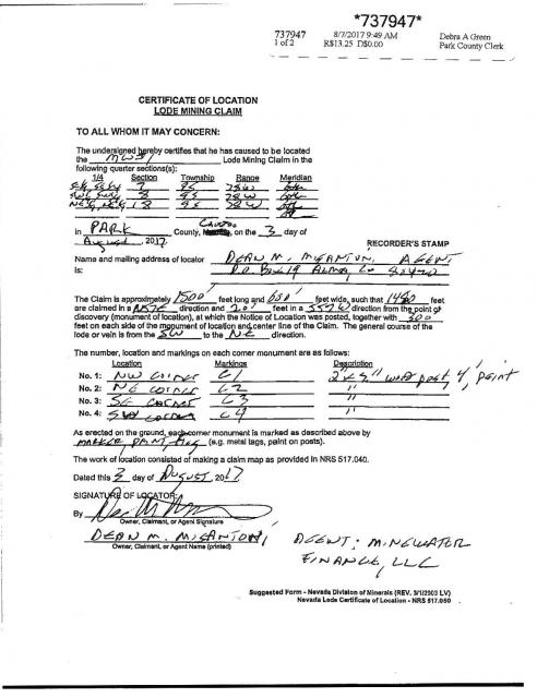
Due to the high grade nature of the gold ore stockpiled on this claim,the area is patrolled and monitored. This Federal Mining Claim is located, recorded, and maintained in accordance with 43 C.F.R. Part 3800 and 30 U.S.C. 22 et seq.; 43 U.S.C. 1744 and all appropriate state laws. All persons are warned that disturbance of the monuments, surface, or improvements on this claim or removal of minerals of any type without permission of the claimant(s), will result in their prosecution under the appropriate state and federal statutes.
HISTORY:
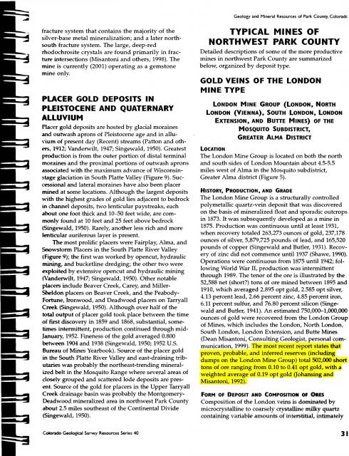
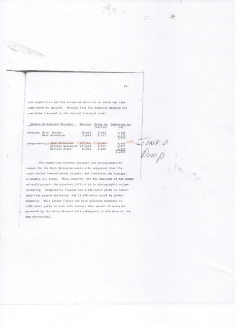
The London Mine Group was developed on pollymetallic quartz veins associated with the Great London Fault. According to documentation by Singewald and Butler (1941) the ore mined between 1895 and 1910 averaged 2.895 opt gold, 2.858 opt silver, 4.13 % lead, 2.66 % zinc, 4.85 % iron, 6.11 % sulfur, and 76.8 % silicon. The most recent reports published by the Colorado Geological Survey state that remaining mine and stockpile resources range from 0.10 to 0.41 opt gold having a weighted average of 0.19 opt gold. Most of the Tonko #1 CMC289770 mining claim was formerly known as the Jewett #1 CMC94664 and the Jewett #2 CMC94665 mining claims that were held by London Mine Venture from 1935 through 1991. The stockpile on Tonko #1 was estimated by Behre Dolbear & Company, Inc. in a report dated March of 1985 to contain 172,000 tons of gold ore!
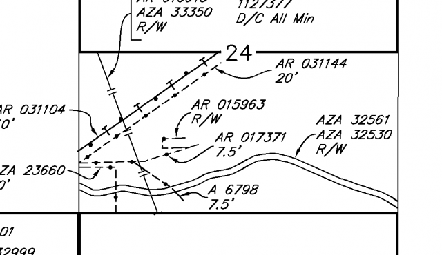
MINING CLAIM MAP:
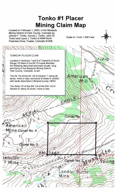
|
GOOGLE EARTH VIEW OF CLAIM:

|
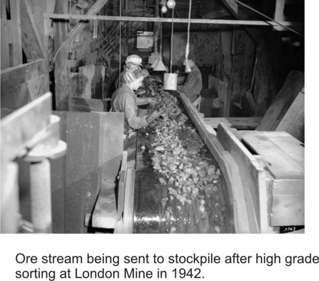
HIGH GRADE SORTING OF ORE:
This photo shows the limited number of employees hand sorting out the exceptionally high grade ore being transported from the mine. Only the highest grades of visible gold ore were hand picked off of the conveyor belt and shipped out for processing. The mine had taken out all processing equipment after World War I due to high taxation. The gold ore stockpile was created by using a small mining train that traveled about 1/4 mile uphill from the sorting facility and dumped along the mountainside for future processing. The round-trip for stockpiling was about 1/2 mile and the volume of ore that was stored now looms over the local area. Since the hand sorting crew wore thick gloves and the speed of the conveyor belt moved exceptional specimens right past the sorting crew, substantial volumes of exceptionally high grade ore was subsequently transported out to the stockpile.
|
STOCKPILE PHOTO:
|
CONTACT:
President of Tonko Mining Company, Inc.
Posted by: GoldenSilva Jan 6 2018, 02:15 AM
How much is this Claim? Also, do you know of more claims for sale other than this one?
Posted by: ASTROBLEME Jan 6 2018, 05:51 PM
The most recent gold mining activity near Fairplay is netting that owner 20% of the gold found on his claim. Following that percentage, a buyer for the Tonko #1 should be willing to negotiate for a multi-million dollar deal.
CONTACT:
President of Tonko Mining Company, Inc.
Posted by: Crusty Jan 6 2018, 06:51 PM
Wow, another amazing Tonko claim. Good luck with your sale!
Posted by: ASTROBLEME Jan 10 2018, 11:52 AM
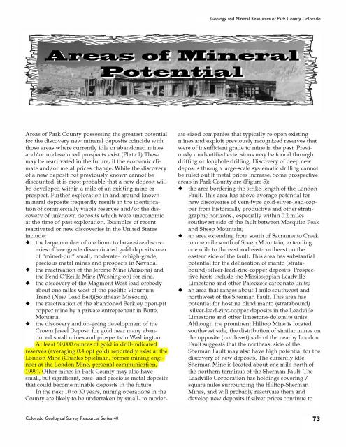
In 2001, the Colorado Geological Survey published this information in their Resource Series 40. I've highlighted the section referencing the gold ore reserves in yellow.
|
Posted by: Crusty Jan 10 2018, 03:44 PM
Was great to finally meet the infamous Johnny Tonko! Thanks for stopping by to chat! Those ore samples were amazing!! 
Posted by: ASTROBLEME Jan 10 2018, 06:03 PM
For further consideration in this matter, the "Misantoni" that is quoted by the Colorado Geological Survey publication above is Mr. Dean Misantoni, PG. He is presently the Qualified Professional overseeing geology and development of mineral and water resources at London Mine. That is the mining property that is adjacent to the gold ore that is stockpiled on Tonko #1 Placer Mining Claim. Here's a link...
http://www.minewater.com/about
Posted by: dino27 Jan 11 2018, 10:46 AM
please see table of bulk sampling results from Behre Dolbear report-
note that the 172,000t east extension waste dump (= Tonko claim) is too low grade (0.055 opt Au) to have made the > 0.10 opt Au
cutoff I state in the other report of mine he posted. It is not part of that reserve. The gold recoveries on ore below 0.1 opt Au go below 50%
|
Posted by: ASTROBLEME Jan 11 2018, 11:32 AM

note that the 172,000t east extension waste dump (= Tonko claim) is too low grade (0.055 opt Au) to have made the > 0.10 opt Au
cutoff I state in the other report of mine he posted. It is not part of that reserve. The gold recoveries on ore below 0.1 opt Au go below 50%
That is the same out-of-date information that your group attempted to use for driving down the value of the mining claim lease they were offering me last September.
Anyone having questions, please contact me directly at;
President, Tonko Mining Company, Inc.
Posted by: Denise Jan 11 2018, 12:01 PM
Dean, do not enter this community trying to cause problems....I'm not in the mood for it right now!
Please cease causing trouble or you will be removed from the forum.
Posted by: ASTROBLEME Jan 11 2018, 12:04 PM
Having owned and worked on this claim since February of 2003, I certainly have much newer information.
Thank you Denise. My family certainly appreciates your concerns for fairness in this community.
Sincerely,
Johnny Tonko
Posted by: dino27 Jan 11 2018, 12:19 PM
Thank you Denise. My family certainly appreciates your concerns for fairness in this community.
Sincerely,
Johnny Tonko
I am all done- said what I need, kindly delete me-
Dean M.
Posted by: Denise Jan 11 2018, 12:47 PM
My pleasure Dean!
Posted by: ASTROBLEME Jan 11 2018, 09:11 PM
I had some requests for pics so I'm sharing them here.
Here's a photo looking west towards the distant London Mine property from about midway along the top of the stockpile.
|
This is a view looking down at the ore while standing there on top of the stockpile.

|
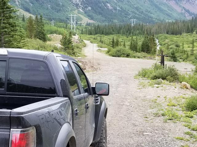
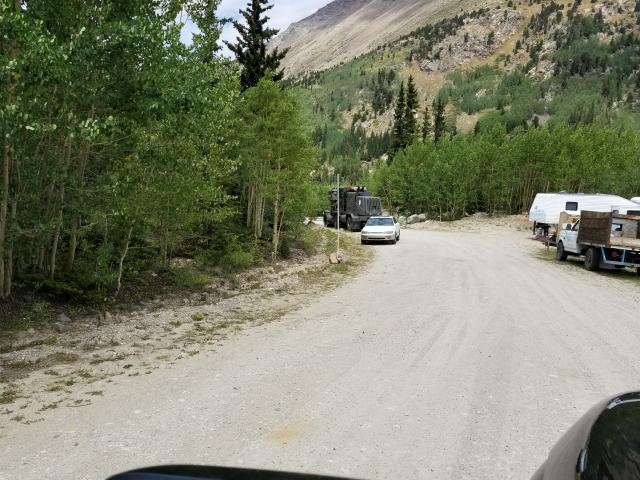
A view looking down from the top of the stockpile. My white 4X4 Titan is parked on the claim where Park County Road 696 meets up with USFS Road 696. Park County does road maintenance up to this junction.
|
As you can see, this is a very large stockpile! I've only been told recently by the adjacent mine interests that this is the 172,000 ton pile mentioned in the report above. At this point, I'm not convinced that interpretation is correct. To me, the stockpile looks much larger than what's being rumored.
Please continue to contact me at the link below.
Sincerely,
Johnny Tonko, President of Tonko Mining Company, Inc.
Posted by: GeoMatt Jan 11 2018, 09:15 PM
Thank you Denise. My family certainly appreciates your concerns for fairness in this community.
Sincerely,
Johnny Tonko
Fairness means that all have input, and can be heard. Not that people are chastised or silenced when contradicting information or opinions are presented. Good luck with your attempt to sell, but honestly I chuckled at your notion of the valuation.
Posted by: Gene Kooper Jan 12 2018, 04:34 AM
If you read the tabulation sheet kindly provided by Mr. Misantoni, you will note that the volume of the dump was computed from photogrammetric methods. Only two dumps were surveyed. Photogrammetric methods are less accurate, esp. on steep terrain.
Posted by: Gene Kooper Jan 12 2018, 04:45 AM
GeoMatt,
I too am disappointed at the above responses by the administrator and Mr. Tonko. Dean Misantoni is a well respected mining geologist who I have worked with since 1995. In the thread I started on the new mine above the old Sweet Home Mine, the published article starts off with a brief history of the old mine. One of the photos includes Dean at the portal of the old Sweet Home Mine. The other article I linked in that thread is on the history of the Sweet Home Mine. The article includes a plethora of maps that attribute the underground mapping to Dean. In my opinion, the geology mapping he did at the Sweet Home Mine is second to none. Anyone with access to the Mineralogical Record issue devoted to the Sweet Home Mine should read the article, "Geology of the Sweet Home Mine and Alma District [Colorado]", by Dean Misantoni, Miles L. Silberman & Bryan K. Lees, 1998.
Mr. Tonko "quote mined" a paragraph of a report published in 1992 by Mr. Misantoni and another geologist, which based on the report falsely cast his dump in a favorable light. To add additional impact and a false importance to the obvious quote mine, Mr. Tonko then extolled the professional qualifications of Mr. Misantoni in a second post. Dean's post was an attempt to correct the false impression given by Mr. Tonko that the dump on the Tonko #1 Placer was of high grade based in part on the work and reputation of Dean Misantoni. I would have likely reacted in a similar fashion to Mr. Tonko's posts if I were the author of the report.
Denise,
I saw no attempt by Mr. Misantoni to create problems on this forum, nor was his initial reply an ad hominem attack on Mr. Tonko. Dean has a professional opinion that differs from Mr. Tonko. He provided a table that supports his opinion. Mr. Tonko's response was that the analyses provided are outdated and that his sampling efforts have determined the dump to be of higher grade. I wholeheartedly agree with GeoMatt's assessment. If a poster is so thin skinned that expelling a Professional Geologist for providing his professional opinion is deemed appropriate because his research arrived at a different conclusion then, in my opinion, this is not a forum that fosters an open sharing of ideas. That was driven home when that poster stated this, " My family certainly appreciates your concerns for fairness in this community" right after Dean was banned.
And yes, I realize that this is your forum and you have the right to do whatever you deem appropriate. Should you decide that my last three posts necessitate my expulsion too, also, I am fine with that. Before I signed up here, I introduced myself via email and asked Dan if he thought my posting here would be okay. He replied with, "Hi Gene, Thanks for your introduction and checking in advance. Yes wed be happy to have your future participation in the forums." I told him that I would never solicit my professional services to anyone on this board. I've always tried to maintain a professional and respectful demeanor in my posts. As you are aware I post using my real name without any alphabet soup after it. I have freely shared my 35 years of research on mining law and mineral surveys with the members of this forum. I do ask one thing should you decide to send me to the same place as Dean; I request that you delete my 98 posts. I cannot say it any planer than I prefer that my posts all be deleted should you decide that I am no longer welcome here. Why would my posts hold any value to you if my continued presence does not?
My question to Mr. Tonko is a simple one. If it is true that the tabulated data provided by Dean Misantoni is outdated and your recent sampling program shows higher Au reserves, then why did you ever decide to quote mine the outdated report? It would seem to me that quoting an inaccurate report (your assessment) would be detrimental to convincing prospective buyers to purchase your possessory right the the minerals within the Tonko #1 Placer. That old work by Mr. Misantoni was conducted in the 1980s and published in 1992. The old owner of the London Mine was Ben Wright. He was a mining attorney that invested in many mining properties in Park and Lake counties. He also held a plethora of unpatented mining claims. Nine years ago I conducted some land survey work along the London Fault. A search of the LR2000 system showed numerous claims were abandoned and closed in 1991 and 1992, including the dump within the boundary of the Tonko #1 Placer. That ground remained unclaimed until you staked your 5 claims in 2003. My impression from talking with mine owners in the area is that the ground was abandoned based at least in part on Mr. Misantoni's report.
Posted by: Denise Jan 12 2018, 09:19 AM
Gene, I stand by what I said. It was obvious that Dean only joined this community to "dump" on Mr. Tonko's post. He was only removed from the forums because he asked to. According to him, he said what he needed to say. This community has always been very respectful of one another and It will remain that way. I have a very low tolerance for trouble makers, even if they are well respected and knowledgeable. This is the way Dan and I wanted it and it is the way it will remain. No, I do not think that your last three posts necessitate your expulsion. Why are you trying to make this about you now? Did I say anything to you or are you just looking for a reaction from me also? I would have reacted the same way if he joined the forums to only jump on one of your posts.
"This is not a forum that fosters an open sharing of ideas."  This forum has always thrived off of open sharing ideas and will remain that way. History shows this, just read the threads and one can see.
Posted by: ASTROBLEME Jan 12 2018, 10:10 AM
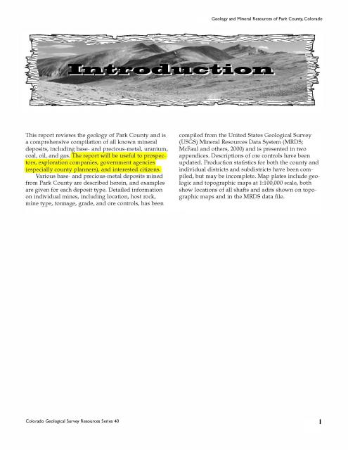
Please understand that the report I'm quoting is public information from a state government document that was first published in 2001. Presently, interested parties can download the full version dated 2013 without charge from the Colorado Geological Survey at this link;
http://coloradogeologicalsurvey.org/wp-content/uploads/2013/08/Park%20County%20Book.pdf
On page 31, the newest report clearly states that "proven, probable, and inferred reserves (including dumps on the London Mine Group) total 502,000 short tons of ore ranging from 0.10 to 0.41 opt gold, with a weighted average average of 0.19 opt gold (Johansing and Misantoni, 1992). The old out-of-date information posted was just 1 page from a private source that is now 33 years old, being dated clear back to 1985. Of particular interest in this matter is the minimum grade from the newest report is 0.10 opt. Only one of the 5 dumps in that old report exceed that 0.10 minimum grade published in the Colorado Geological Survey report. The old report's dump with the highest grade was only 8,000 tons with 0.147 oz/ton. The four other dumps on that old page total 390,000 tons with grades between 0.075 and 0.055 oz/ton. Clearly the newer information is much more comprehensive and most importantly, fully available for the public's use.
Here's page 1 of the newest report that describes the data that was compiled. I've placed a yellow highlight on a section to draw attention to the purpose of the document.
|
I hope that this helps further the understanding of this offering.
Johnny Tonko, President of Tonko Mining Company, Inc.
Posted by: ASTROBLEME Jan 14 2018, 11:03 AM
Here's the math...
The newest data presented in the Colorado Geological Survey report clearly states that "proven, probable, and inferred reserves (including dumps on the London Mine Group) total 502,000 short tons of ore ranging from 0.10 to 0.41 opt gold, with a weighted average of 0.19 opt gold (Johansing and Misantoni, 1992). When the drill-indicated reserves remaining in the mine (Speilman 1999) are added in to the 33 year old survey data, here is the result;
North London 50,000 tons
West Extension 8,000 tons
East Extension 172,000 tons
Central Extension 133,000 tons
Sorting Plant 35,000 tons
Drill-Indicated 125,000 tons
TOTAL 523,000 tons
When this total is further adjusted downward by the amount of material processed by the Joint Venture and other testing, then the data fits very well against the total of 502,000 short tons published in the newest report from the Colorado Geological Survey.
The data is found on the 2 pages from the newest report posted below.

|
|
Taking into account the weighted average stated in the report of 0.19 opt, the math works out to be 32,680 ounces of gold in the East Extension (aka Tonko Stockpile).
If interested in this offering, please contact me directly at;
Johnny Tonko, President of Tonko Mining Company, Inc.
Posted by: Gene Kooper Jan 14 2018, 04:26 PM
I didn't realize that two "PG"s could strike so many nerves.
I know that Mr. Tonko is fully aware of this, so I'll leave this bit of information as my last post for those not fully familiar with the rules for association placers. The U.S. mining laws permit a single claimant to claim up to 20 acres as a placer claim. An association of individuals can claim up to 20 acres for each one in the association with a maximum of 160 acres claimed by 8 individuals. Should the association decide to sell their possessory right to the surficial minerals, a single person or corporation can be the buyer. However, the discovery of a locatable mineral must be proved prior to the transfer.
In the past, what constituted a discovery of a locatable mineral was the "prudent man" test. Today, that standard has been replaced with an economic standard. In other words, the deposit must be economic, which also means that it is dependent upon the price of the valuable mineral at the time the discovery is to be proven. In the past, it was more economic to claim placer ground as association placers. The association only had to pay a "single" maintenance fee. Now the BLM charges $155 times each 20 acres in the placer. So for a 160 acre association placer the current maintenance fee is $1240. If the old system had not been changed it would be only $155.
Cheers to all and best of luck with your sale Mr. Tonko.
Posted by: ASTROBLEME Jan 14 2018, 05:09 PM
Everyone,
I would encourage you to do your own research into this offering and if desired, seek assistance from licensed professional(s) that are qualified in any matter that concerns you. Following any of the legal advice being offered from posters on this thread is at your own risk.
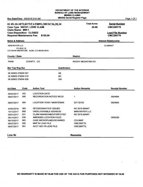
The claim is properly maintained and all fees have been timely paid as required by law. The federal records are attached below.
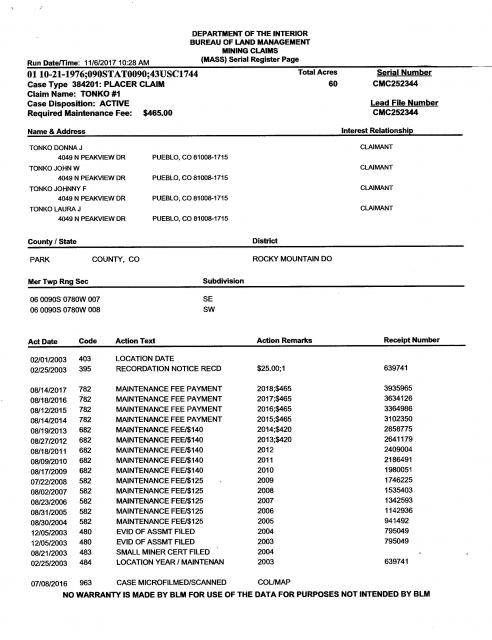
|
|
If interested in this offering, please contact me directly at;
Johnny Tonko, President of Tonko Mining Company, Inc.
Posted by: GeoMatt Jan 17 2018, 09:55 AM
I would encourage you to do your own research into this offering and if desired, seek assistance from licensed professional(s) that are qualified in any matter that concerns you. Following any of the legal advice being offered from posters on this thread is at your own risk.
I'd be more than happy to help anyone interested in these claims with their DD. Heck, I'd probably do it for free.
BA Geology
MS Mining Engineering
PG in Wyoming and Texas
Registered member of SME
QP for NI43-101 and CP for JORC
17 years of global exploration and mining experience
Track history of exploration success and project development
I agree with Mr. Tonko, some of the posters on this board have more experience/knowledge than others. But I'll listen to anyone, because everyone has something to contribute.
Posted by: EMac Jan 17 2018, 06:56 PM
Johnny - best of luck in your endeavors sir.
Denise - Can we vote to keep Dean on the island? I understand your offense, but also understand Dean's. Gene makes a good point: IMO, a professional report's author has every right to clarify other's representations of their data or analysis. To acquiesce, knowingly allowing misrepresentations to stand unaddressed could result in a loss of professional reputation.
Perhaps Dean could have been a bit more introductory if for nothing more than I was confused by who this guest_dino was since I was skimming the post until I saw Matt and Gene chiming in. Generally I learn something from their posts.
Does anyone disagree that having esteemed, and professionally accomplished folks like Gene, Matt and Dean contributing is a significant benefit to this community? I'd love to get them out to one of our overnight shindigs so they can see how excited we get about the piddly amounts of values we bust our asses to find; if nothing else than to hear their stories around the campfire at night.
Posted by: ASTROBLEME Jan 18 2018, 08:00 PM
Everyone expressing an opinion on this FOR SALE offer, especially all the posters that claim some sort of "professional" credentials, please post a full copy of the peer reviewed report that supports your opinion(s). The State of Colorado report I've referenced is easily accessed free of charge as I've stated above.
Sincerely,
ASTROBLEME (aka Mr. Tonko)
Posted by: EMac Jan 19 2018, 09:50 AM
Have you tried posting this in ICMJ? I just looked and didn't see this among the many offers for claims, partnerships, investors, etc. Not a single claim in Colorado sadly. Seems that might be a more suitable place to post what you value to be a multi-million dollar claim.
Posted by: Denise Jan 19 2018, 10:00 AM
Johnny was told by Dan that he could post his claims for sale here, so I have no problem with him posting it here either.
Posted by: EMac Jan 19 2018, 05:26 PM
No doubt; I'm just thinking that when I sold my car, it got posted multiple places. Seems a car is much easier to sell, so my thinking is marketing a mining claim might require posting in multiple locations. I'm sure Johnny has done this frankly, but I didn't see it in ICMJ.
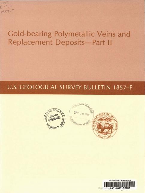
Posted by: ASTROBLEME Jan 21 2018, 12:49 PM
In addition to the Colorado State report cited above, here's a Federal report from 1990 that has detailed information on the London Vein and mining operations. The report is Gold in the Alma Mining District and it starts on page F 19. It can be read for free at the following link;
https://books.google.com/books?id=GoGvjUpOZzMC&pg=SL6-PA27&dq=london+mine+new+vein&hl=en&sa=X&ved=0ahUKEwjxkKjl0OnYAhVN7WMKHZPiC9MQ6AEILzAB#v=onepage&q=london%20mine%20new%20vein&f=false
ASTROBLEME
Book Cover
|
Posted by: ASTROBLEME Jan 31 2018, 09:53 AM
There was an incident in early 2013 that revealed publicly that "valuable ore" existed in piles at the London Mine. Here's a copy of that document;
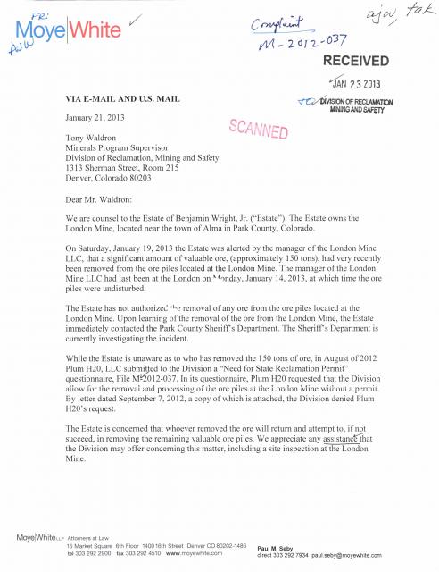
|
|
Please send your questions to me at;
Johnny Tonko, President of Tonko Mining Company, Inc.
Posted by: ASTROBLEME Feb 2 2018, 12:48 PM
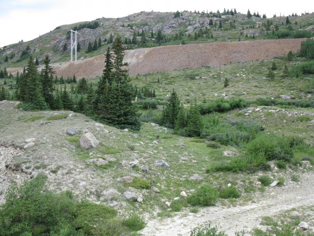
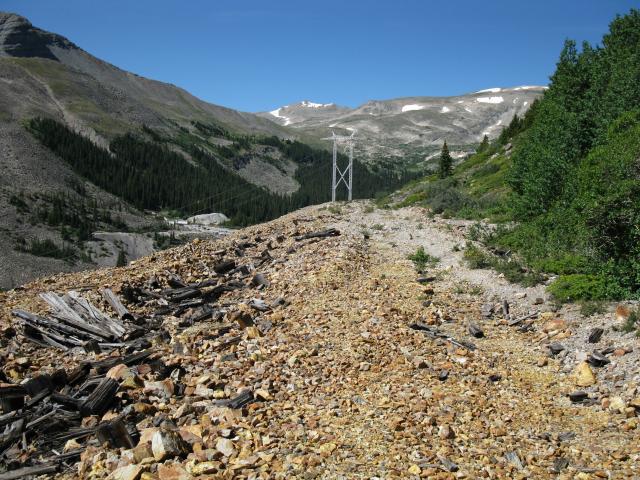
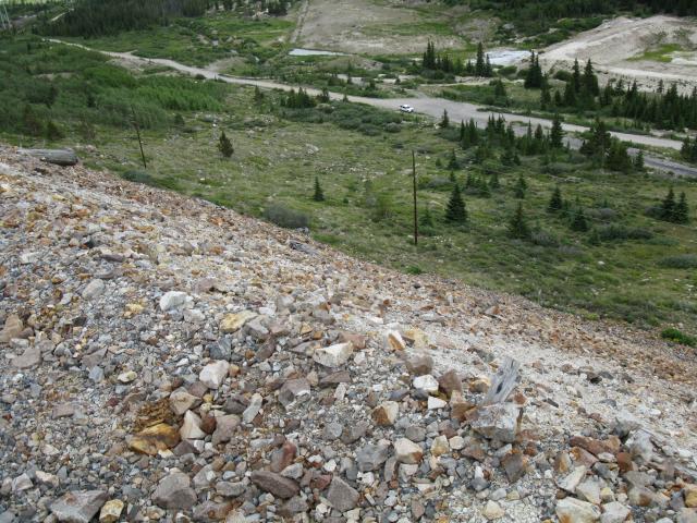
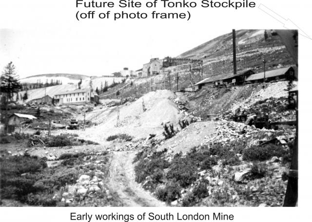
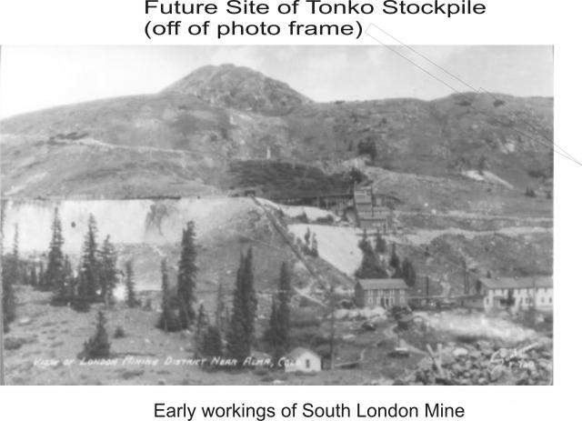
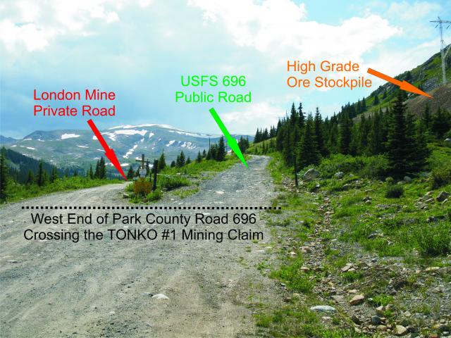
Two historical photographs showing the extensive infrastructure and the "mine dumps" at South London Mine are posted below. The Tonko #1 Vicinity Map is also posted to provide a view of where the high grade ore stockpile is located with respect to the lands where the mine buildings have been removed. It is important to note that the Tonko Stockpile was placed far away from the patented mining company lands. In fact, the ore was transported up 0.4 miles, thus making for a round-trip of 8/10 of a mile to and from the the hand sorting site out to stockpile and back. This effort took a lot more time and money to complete in comparison to the dumping of ore piles that were placed near the mine buildings. The stockpile itself is nearly 1/4 mile in length!
|
|
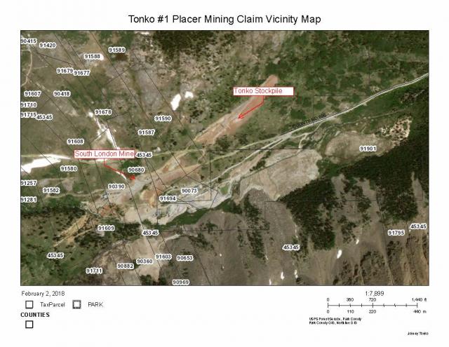
|
Please contact me directly at;
Johnny Tonko, President of Tonko Mining Company, Inc.
Posted by: ASTROBLEME Feb 4 2018, 12:03 PM
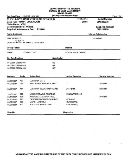
DEAN MISANTONI OVERSTAKED THE TONKO STOCKPILE SIX MOTHS AGO!
Mr. Misantoni has been involved with the London Mine for over 30 years and is a Certified Professional Geologist (CPG #11276) with a B.S. and a M.S. He also was an author of the report cited earlier in this thread from the Colorado Geological Survey stating that proven, probable, and inferred reserves (including dumps on the London Mine Group) total 502,000 short tons of ore ranging from 0.10 to 0.41 opt gold, with a weighted average of 0.19 opt gold (Johansing and Misantoni, 1992)".
The claimants concerted effort to gain a mineral interest in the stockpile location has resulted in NO rights, title or interest in the Tonko #1 Placer Mining Claim. Lode claims staked under Federal Mining Law, like Misantonis, are only for rock in place such as well-defined veins. Placer claims, like the Tonko #1 offered here, covers the loose materials including mine dumps and mill tailings. Misantonis claim map shows the center-line following along the top of the Tonko Stockpile.
It appears from Federal records that although an amended claim was filed at BLM just 2 weeks prior to the 2018 assessment year, no fee payment was made at that time. This claim will likely be forfeited by operation of the law as soon as BLM adjudicates the matter.
The records are posted below;
|

|
|
Please contact me directly at;
Johnny Tonko, President of Tonko Mining Company, Inc.
Posted by: ASTROBLEME Feb 18 2018, 12:44 PM
While most of the ore has gold that isn't visible to the naked eye...I collect specimens with visible gold from the high grade stockpile at will.
The 2 pics below are of high grade ore I sliced with an old 10 inch diamond saw. Keep in mind that my saw doesn't have the precision of a jewelry set-up, yet the cut still shows the native gold by the smearing of soft metal by the spinning blade across the specimen. The close up view has a millimeter scale.
Cut Specimen from Tonko #1
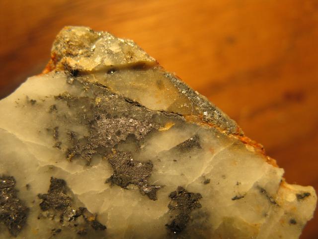
|
Cut Specimen Tonko #1 Close Up
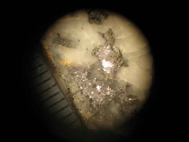
|
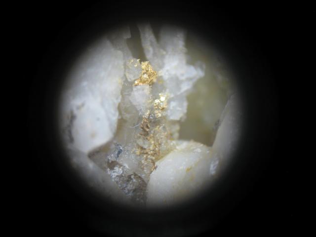
The 2 pics below are of gold with quartz crystals.
Gold with Quartz
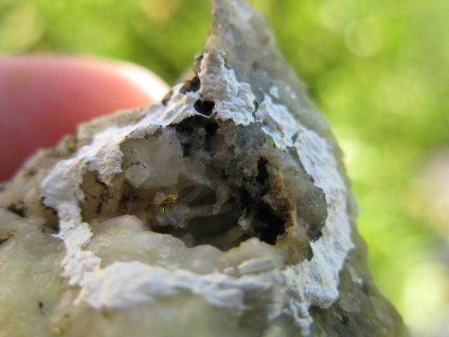
|
Closeup view of Gold in Quartz.
|
Here's a link to an exceptional "high grade" gold specimen recovered from London Mountain with a metal detector;
http://www.davebunkminerals.com/specimen.htm?id=777#.WootOlTwaUl
Please contact me directly at;
Johnny Tonko, President of Tonko Mining Company, Inc.
Posted by: Crusty Feb 19 2018, 11:00 AM
beautiful specimins!!
Posted by: johnnybravo300 Feb 19 2018, 04:11 PM
So he never wanted anything to do with the stockpile in 30 yrs until you found values and claimed it as a placer?
No wonder he sounds like a douche.
Posted by: ASTROBLEME Feb 19 2018, 07:18 PM
SOME MORE HISTORY
My Grandfather mined in the coal and gold fields and his stories were a motivating factor in my life-long interests in prospecting and mining. His work was well before the protections afforded to miners safety was even being thought about. He suffered from "consumption" at an early age and his stories are sill etched into my mind even after all these years. He had said many times to the family that "being belly deep in cold water in the mine tunnels was better than the life I had before I came to America".
Mining activities at London Mountain have a very long history. With respect to this claim offering, all the original owners, lawyers, accountants, mining engineers, miners and milling operators have long since passed away, thereby taking much of the hands-on history with them. Their efforts to tunnel, blast and hand sort ores from London Mountain were extra-ordinary. I am truly moved by all their hard work in developing the precious and base metal resources at London Mountain.
The stockpile was originally known as the Jewett #1 and Jewett #2 , likely named in honor of one of the mine owners that was working the site at that time. These claims were held by London Mine Venture from 1935 through 1991. It was during the 1990's that mining laws were changed such that unpatented claims had to be verified by recording public notices of complying with the the legally required assessment work or in the alternative, paying assessment fees to keep the claim active.
I had been prospecting the Park County area for many years and always wondered what the ore placed alongside South London Mountain was all about. Once I found that the claim had been forfeited (due to no action after the mining law changes a few years before), I went to the ore pile to take samples. I was astounded by what I found and placed a claim upon the site. Things were very quite while my family went about our business from that point until very recently.
After more than 15 years of working the high grade stockpile, I was surprised by a major uptick in interest in leasing or buying the claim. This flurry of activity occurred just prior to the end of the 2017 Assessment Year. At about that same time, I discovered that the newest operators of London Mine constructed a gate across Park County Road 696. They attempted to deny access to my family's claim and went so far as to threaten trespassing charges if we used the road. I then worked with several County, State and Federal entities to re-open the road for the historical public access. By November 2017, the roadway was again opened to public travel upon Park County Road 696 and USFS Road 696 going up London Mountain just as it has since 1876.
Please be assured that any prior claim jumping, overstaking or mineral trespassing has been dealt with appropriately. Likewise, measures are in place to deal with future instances of the same.
I appreciate all the interest expressed in this offering. Thank you and if you have any further concerns or questions about this offering, please contact me directly at;
Johnny Tonko, Prresident of Tonko Mining Company, Inc.
Posted by: johnnybravo300 Feb 20 2018, 08:45 PM
Very interesting history. Grandfathers sure can have some crazy stories and they tell it like it is!
It's amazing to me that a pile like that sat unwanted after the hardest work was done.
Is it free gold that can be crushed and released or needs a chemical leach? That's quite a pile of nice ore to come across and you hit the jackpot on that one. That's was a genius idea to look into that.
Seems that could be a sure thing with the right equipment and knowledge.
I sure wish my family was out here that long ago.
Posted by: ASTROBLEME Feb 23 2018, 07:48 PM
The richer mines in Colorado's high country had to find ways to drain water as the workings were developed so that the miners wouldn't be working "belly deep in cold water" like my grandfather endured.
At London Mine, they constructed a drainage tunnel to pull water out of the miner's path to the gold that consisted of more than 100 miles of tunnels and stope workings. Today, in addition to ore reserves left behind at London Mine, there is a water resource that's worth significant money. Presently, the City of Aurora is considering an initial purchase of 1,400 acre-feet of the polluted mine waste water that is flowing out of the drainage system into South Mosquito Creek from the London Mine each year. There are reports that the city is willing to spend $22,000 per acre foot for this polluted mine water flow. That amounts to a total of $32,000,000.00 US Dollars for the purchase of the water right(s)!
There was a video tour produced by the Aurora Staff back in November last year that shows just a small fraction of the mine tunnels near our claim offering. The high grade ore loading chute that was highlighted is very interesting. Here's the link...
https://youtu.be/uCNLNvJsu24
Please continue to contact me directly at;
Johnny Tonko, President of Tonko Mining, Inc.
Posted by: ASTROBLEME Mar 12 2018, 11:12 AM
PLEASE TAKE NOTICE:
The asking price for this 60 acre placer mining claim is $2,459,600.00 (Two Million, Four Hundred Fifty-Nine Thousand, Six Hundred U.S. Dollars). With gold being presently valued at approximately $1,300 per troy ounce, and considering local claim owner's leasing rates now averaging 20%, our asking price was calculated based on the 9,460 troy ounces of gold contained in the stockpile as reported in March 1985 by the Behre Dolbear & Company "Feasibility Analysis of the London Mine". That is the report that was submitted by Dean Misantoni, Certified Professional Geologist (CPG #11276), earlier in this thread. In addition, silver, copper, zinc and lead in the stockpile ores...along with all the virgin gravel placer lands also existing on this claim...will be included at this price. Some of these substantial virgin gold placer grounds are easily identified by the "rounded boulders" observed in place (alongside the road intersections and below the stockpile) in the last photo below. Non-consumptive use water could be sourced for mining purposes where South Mosquito Creek flows across the southeast part of the claim.
Due to the high grade nature of the gold ore stockpiled on this claim,the area is patrolled and monitored. This Federal Mining Claim is located, recorded, and maintained in accordance with 43 C.F.R. Part 3800 and 30 U.S.C. 22 et seq.; 43 U.S.C. 1744 and all appropriate state laws. All persons are warned that disturbance of the monuments, surface, or improvements on this claim or removal of minerals of any type without permission of the claimant(s), will result in their prosecution under the appropriate state and federal statutes.
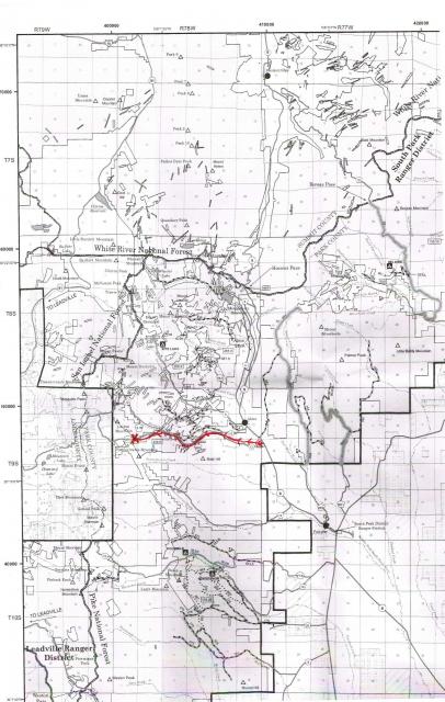
When visiting the vicinity, my family would appreciate your respect for our ownership interests and that of the adjacent mine owners. Public access roadways to the claim are depicted by the red marked route on the attached map. If an on-site inspection or any sampling of this mining claim is desired, that must be arranged in advance by contacting me directly at;
Johnny Tonko, President of Tonko Mining Company Inc.
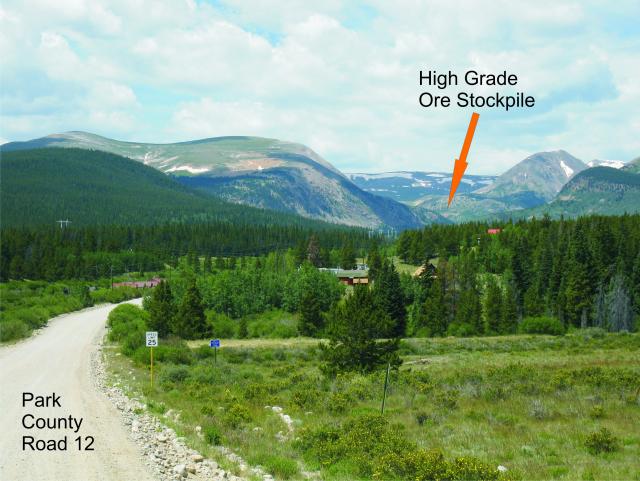
Park County Road 696 is maintained year-round and there is a wide parking area right before the intersection with the private London Mine Road and USFS Road 696. The high grade stockpile is visible from Colorado State Highway 9 at the Mosquito Gulch Road near Alma. That is also known as Park County Road 12 and it passes through the famous South Park City and then meets up with Park County Road 696 about 5 miles west of State Highway 9. I've posted photos of the area below.
Sincerely,
ASTROBLEME
|
|

|
Posted by: ASTROBLEME Apr 6 2018, 10:12 AM
This past Monday, BLM issued a decision on the Minewater LLC mining claim that was staked by Dean Misantoni over my family's mineral interests. That short-lived claim is now CLOSED as indicated in the official record copied below.
|
This offering is for 100% ownership interests in the TONKO #1 Placer Mining Claim.
Posted by: Crusty Apr 6 2018, 11:53 AM
good news! Hope you find a buyer soon!
Posted by: ASTROBLEME Apr 6 2018, 06:36 PM
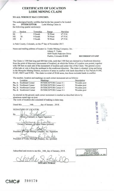
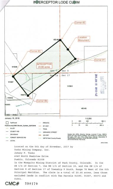
I want to extend our family's offer to the successful buyer of TONKO #1 placer claim to also include in their purchase a 100% ownership of the INTERCEPTOR lode. The INTERCEPTOR mining claim is detailed below;
|
|
Please contact me at;
President of Tonko Mining Company, Inc.
Posted by: reinhold Aug 12 2018, 09:27 AM
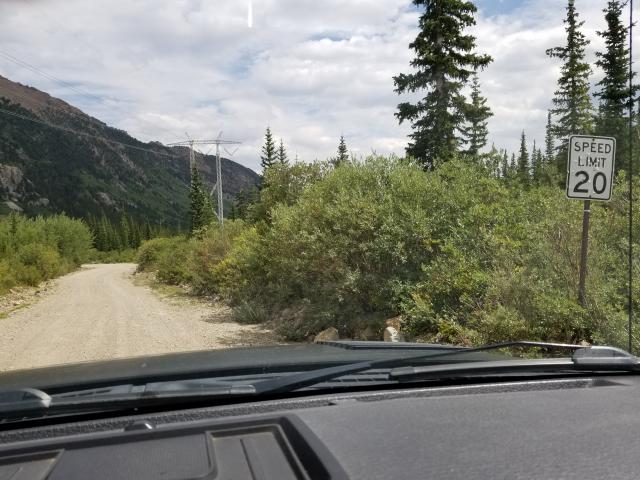
Though I was just there for hiking, I thought you might to interested to know that the operator is using this gate again. It was open yesterday morning, but he ran me down in his SUV while I was considering a fork in the road (the fork in your picture here: http://www.coloradoprospector.com/forums/index.php?act=attach&type=post&id=11401). He accused me of trespassing, and he locked the gate as we left. I can't understand how he can unilaterally close a public right-of-way.
Posted by: ASTROBLEME Aug 12 2018, 11:49 AM
I was working on the stockpile about a month ago and the lower green metal pipe gate was open and the cable gate at the "fork" was also open. Didn't have any problems. That fork in the road is on USFS lands and the Tonko #1 Mining Claim. The public is allowed to be there!
It would be helpful if you would file a report immediately with the Park County Sheriff, Fred Wegener;
1180 CR 16
P.O. Box 604
Fairplay, CO 80440
Ph: 719-836-2494
Fx: 719-836-4113
And the USFS South Park Ranger District;
P.O. Box 219, 320 Hwy 285
Fairplay, CO 80440
Phone (719) 836-2031
Fax (719) 836-3875
This is a pic of the opened cable gate looking downhill onto the Park County Road 696 at the fork.
|
This is a pic of the area roads on our claim. The public has a right to be on the Park County Road 696 and on USFS Road 696!
|
Posted by: reinhold Aug 16 2018, 06:13 PM
It would be helpful if you would file a report immediately with the Park County Sheriff, Fred Wegener;
1180 CR 16
P.O. Box 604
Fairplay, CO 80440
Ph: 719-836-2494
Fx: 719-836-4113
And the USFS South Park Ranger District;
P.O. Box 219, 320 Hwy 285
Fairplay, CO 80440
Phone (719) 836-2031
Fax (719) 836-3875
It was the "lower green metal pipe gate," preceding by a half-mile or so the fork you photographed, where he was controlling access. He actually had to unlock and open it to let us out. To my understanding, this gate is right in the middle of the county road. He has some equipment and a trailer alongside the road just to the west side of this gate.
I stopped by the Park Cty Sheriff's office on my way out of town on Saturday to ask about the situation. Though the office was technically closed, there was an officer outside. I spoke with him, and he stated that the 696 road is a "weird mix" of public and private road. I was confused by the response, and I left it at that. Do you think it would be worthwhile to ask them about it again?
Posted by: reinhold Aug 17 2018, 02:19 PM
Called the FS line today, and they said that they couldn't help since the gate isn't on their road. Seems Park County's offices are closed on Fridays, so I'll try again next week.
Posted by: ASTROBLEME Aug 17 2018, 03:22 PM
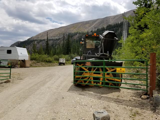
I went up to my claim on Wednesday to get some drone photos. There was a man and woman walking near the blockade and a couple of cars were parked outside the gate along the road. Nobody stopped me but I became very concerned about the dangerous conditions that have been created on that blind corner. There were children's bikes with training wheels, unlicensed vehicles and heavy equipment alongside or upon the travel surface of the road at that green gate. It appears that someone is now living "on" the road. Anyone traveling up there needs to use extra caution!
|
I filed a complaint via Email yesterday morning with the Park County Right-Of-Way Division. Here's their link;
https://www.parkco.us/611/Right-Of-Way-Division
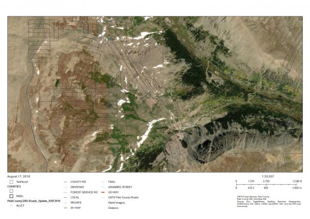
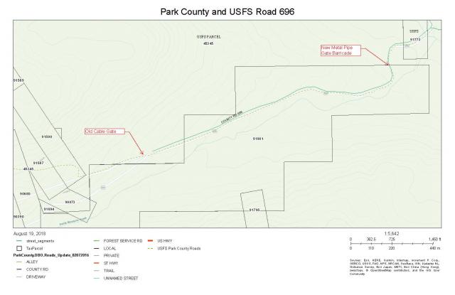
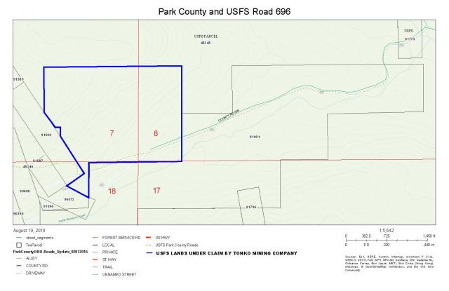
The Park County GIS data clearly shows the county and USFS ownersip of 696 all the way up to the top of Mosquito Pass. This would be a good visual aid if you're meeting with authorities on this matter. The light green dashed line is USFS road that meets up with Park County 12 at the summit of Mousquito Pass. This road is also a Designated Snowmobile Route as depicted on the current Pike National Forest map.
|
reinhold, I appreciate your efforts to follow-up on this. This problem needs to be resolved before someone crashes into the gate or worse!
ASTROBLEME
Posted by: Clay Diggins Aug 18 2018, 12:30 PM
Is the gate locked Johnny?
All of 9S 78W Section 18 L5 is https://glorecords.blm.gov/details/cdi/default.aspx?doc_id=287872&sid=voptoea1.r4g#cdiDetailsTabIndex=1. The 120 acre placer patent there in the north of Sections 18 and 17 precedes the public way by three years.
If the gate isn't locked I doubt there is any legal issue. Private landowners have a right to protect their property even if a public way passes through. As across the rest of the west the right thing to do when encountering a gated road is to close the gate after you pass through if it was closed or leave the gate open if it was open.
The fact that the gate indicates private land and no trespassing doesn't change the status of the public way if there is one. ROWs and easements, if they exist, are not an ownership issue but one of estate. The subservient estate (private landowner) doesn't give up their rights to anything but the surface travel of the public across their private lands. To put it another way a public road is an abstract right that doesn't result in the County owning the land the road is located on.
Interestingly the Master Title Plat doesn't indicate a ROW or easement where the road crosses the federally managed lands. That makes things rather ambiguous as far as a right to access the road despite the county and forest designations. That's why you are likely to get a shrug from the Sheriff.
If your passage has been physically prevented it's probably going to be up to you to prove that right in a civil proceeding. If you do have passage but are inconvenienced to open and close the gate I doubt you will find recourse in the law. Just an experience based opinion and not meant to be legal advice.
Posted by: ASTROBLEME Aug 18 2018, 06:52 PM
All of 9S 78W Section 18 L5 is https://glorecords.blm.gov/details/cdi/default.aspx?doc_id=287872&sid=voptoea1.r4g#cdiDetailsTabIndex=1. The 120 acre placer patent there in the north of Sections 18 and 17 precedes the public way by three years.
If the gate isn't locked I doubt there is any legal issue. Private landowners have a right to protect their property even if a public way passes through. As across the rest of the west the right thing to do when encountering a gated road is to close the gate after you pass through if it was closed or leave the gate open if it was open.
The fact that the gate indicates private land and no trespassing doesn't change the status of the public way if there is one. ROWs and easements, if they exist, are not an ownership issue but one of estate. The subservient estate (private landowner) doesn't give up their rights to anything but the surface travel of the public across their private lands. To put it another way a public road is an abstract right that doesn't result in the County owning the land the road is located on.
Interestingly the Master Title Plat doesn't indicate a ROW or easement where the road crosses the federally managed lands. That makes things rather ambiguous as far as a right to access the road despite the county and forest designations. That's why you are likely to get a shrug from the Sheriff.
If your passage has been physically prevented it's probably going to be up to you to prove that right in a civil proceeding. If you do have passage but are inconvenienced to open and close the gate I doubt you will find recourse in the law. Just an experience based opinion and not meant to be legal advice.
Hello Clay Diggins,
Although I've never encountered the gate being locked, other people have recently and they have been ordered to leave USFS lands by the operator of the gate blockade. My trip a few days ago through this blockade gave me chills...when seeing kid's bikes with training wheels parked right next to the travel surface of the road that comes in from both an uphill blind corner...and a downhill blind corner... that is being traveled by heavy mining equipment and fast moving recreational traffic. Observing a 5th wheel trailer, satellite dish mounted on a ground buried post, barbecue, commercial generator, porta potty...etc... well this appears to be a family residence established upon the county R.O.W. There are laws that govern this situation and I'm seeking to bring the problem to the attention of others to protect everyone involved.
This area isn't governed by the codes of the west. Park County has Roads and Bridges Regulations that are authorized by, inter alia, Sections COLORADO REVISED STAUTES 30-28-101 et. seq.30-28-133, 43-2-114 and 43-2-201.
Amongst the many road and bridge regulations that have been legally established by Park County, there are two easily understandable regulations for the public to be aware of;
2.1.5 C All roads over private lands that have been used adversely without interruption or objection on the part of the owners of such lands for twenty (20) consecutive years are public roadways.
2.1.5 E All roads over the public domain, whether agricultural or mineral, are public roadways.
Park County Road and Bridge Department seeks the cooperation with all law enforcement officials in administering the provisions of the road and bridge regulations. They also, insofar as possible, develop ways and means to improve traffic conditions. This was what happened last year when I complained of being threatened with trespassing charges when traveling on the subject roadway. The issue is, in my opinion, an already settled matter and the right-of-way will be cleared as prescribed by law by the appropriate government entity.
The county has established speed limits approaching the "barricade". When traveling downhill towards there are 20 MPH signs. Traveling uphill, there are no signs leading into the blind corner. Here's two pics taken on the parcel you've identified as being private patented land. This is condition a few days ago of the road approach from uphill that show the reason to use extra caution on this section of public roadway. Both uphill and downhill travel to this living area has blind corners. The heavy equipment snowblower parked on the travel surface of the R.O.W. has US AIRFORCE license plates stating "FOR OFFICIAL USE ONLY". The white car and white truck had no visible license plates...as required by law when traveling on public roads!
|
|
Thanks for your comments on this matter. It is great to see that other members are willing to step up and assist with an understanding of these pertinent issues to prospectors, miners and the general public that uses these R.O.W.s.
ASTROBLEME
Posted by: Clay Diggins Aug 18 2018, 09:08 PM
Although I've never encountered the gate being locked, other people have recently and they have been ordered to leave USFS lands by the operator of the gate blockade.
This area isn't governed by the codes of the west. Park County has Roads and Bridges Regulations that are authorized by, inter alia, Sections COLORADO REVISED STAUTES 30-28-101 et. seq.30-28-133, 43-2-114 and 43-2-201.
2.1.5 C All roads over private lands that have been used adversely without interruption or objection on the part of the owners of such lands for twenty (20) consecutive years are public roadways.
2.1.5 E All roads over the public domain, whether agricultural or mineral, are public roadways.
ASTROBLEME
Thanks for the reply Johnny. I'm not arguing for or against the gate. I think that's a thing neighbors should work out among themselves if possible.
I included the above quotes from your post to seek some clarity and inject some sense of the reality of the situation into your law cites.
The gate is not on forest service managed lands. The land where the gate is placed is private land just as the rest of Lot 5. Whatever passersby misunderstandings may be there is no forest service managed land to be "ordered to leave" from. The land for miles further beyond the gate location are private.
The adverse use is a little tricky when you consider the facts. As the Sheriff implied there have been gates, cables and road blocks placed on or near that gate area several times in the last 20 years. That might just fulfill the part about the owner objecting to the use? It might be a little more than hard to prove continuous adverse use for any prior 20 year period. The public may or may not have a right to travel on that road but basing a public right on an adverse prescriptive easement is a tough row to hoe.
Since 1921 if a County wanted to make an existing private road public there are https://www.codot.gov/business/manuals/right-of-way/Chapter%202%20-%20ROW%20Plans/Chapter%202%20Plans%20Manual they need to complete. Among those are a survey, title and deed research and a public platting and adoption by the County with full records and public notice/input. You should be able to locate those records at the Park County Recorders office. Getting certified copies of those records, if they exist, would put you in a stronger position to come to an agreement with your neighbor.
Since the placer patent on which the gate is installed was granted before the road existed it would not be a subject of the 1866 Mining Act public domain road grant (so called RS2477). That grant was only for roads across the public lands - not roads across patented private property.
Right of ways and easements (probably the same thing in Colorado) are a pretty involved subject. Just because there are statutes that agree with your assumptions doesn't mean that those particular statutes apply to your situation. Common law is sometimes more powerful than statutes due to the general nature of common law. I would suggest you try to work something out with your neighbor, it's always a better solution to come to an agreement rather than attempting to invoke the government police power to oppose your neighbors actions.
Private property rights are at the very foundation of this country. Here is the narrative from a very similar case in Teller County.
https://www.csindy.com/coloradosprings/rules-of-the-road/Content?oid=1121361
https://www.csindy.com/coloradosprings/judge-acquits-teller-county-man-who-blocked-road/Content?oid=1123826
I hope that information helps you resolve your perceived problem.
p.s. The code of the west regarding gates is very much a https://law.justia.com/codes/colorado/2016/title-35/livestock/article-46/.
Posted by: ASTROBLEME Aug 19 2018, 02:18 PM
I included the above quotes from your post to seek some clarity and inject some sense of the reality of the situation into your law cites.
The gate is not on forest service managed lands. The land where the gate is placed is private land just as the rest of Lot 5. Whatever passersby misunderstandings may be there is no forest service managed land to be "ordered to leave" from. The land for miles further beyond the gate location are private.
The adverse use is a little tricky when you consider the facts. As the Sheriff implied there have been gates, cables and road blocks placed on or near that gate area several times in the last 20 years. That might just fulfill the part about the owner objecting to the use? It might be a little more than hard to prove continuous adverse use for any prior 20 year period. The public may or may not have a right to travel on that road but basing a public right on an adverse prescriptive easement is a tough row to hoe.
Since 1921 if a County wanted to make an existing private road public there are https://www.codot.gov/business/manuals/right-of-way/Chapter%202%20-%20ROW%20Plans/Chapter%202%20Plans%20Manual they need to complete. Among those are a survey, title and deed research and a public platting and adoption by the County with full records and public notice/input. You should be able to locate those records at the Park County Recorders office. Getting certified copies of those records, if they exist, would put you in a stronger position to come to an agreement with your neighbor.
Since the placer patent on which the gate is installed was granted before the road existed it would not be a subject of the 1866 Mining Act public domain road grant (so called RS2477). That grant was only for roads across the public lands - not roads across patented private property.
Right of ways and easements (probably the same thing in Colorado) are a pretty involved subject. Just because there are statutes that agree with your assumptions doesn't mean that those particular statutes apply to your situation. Common law is sometimes more powerful than statutes due to the general nature of common law. I would suggest you try to work something out with your neighbor, it's always a better solution to come to an agreement rather than attempting to invoke the government police power to oppose your neighbors actions.
Private property rights are at the very foundation of this country. Here is the narrative from a very similar case in Teller County.
https://www.csindy.com/coloradosprings/rules-of-the-road/Content?oid=1121361
https://www.csindy.com/coloradosprings/judge-acquits-teller-county-man-who-blocked-road/Content?oid=1123826
I hope that information helps you resolve your perceived problem.
p.s. The code of the west regarding gates is very much a https://law.justia.com/codes/colorado/2016/title-35/livestock/article-46/.
Clay Diggins,
Thanks for giving me an opportunity to provide clarity for you in this matter.
First, let me correct you on the roadway. You say "The land for miles further beyond the gate location are private" but in fact, the road crosses public lands in several locations on the way up to Mosquito Pass. The first such crossing is onto USFS public land about 3,250 feet from the new gate/blockade.
Contrary to your statements ,there is substantial acreage of USFS land in Sections 7, 8 and 18 of Township 9 South, Range 78 West of the 6th Principal Meridian. The old cable gate was on USFS land. The green pipe gate and blockade is on the Park County Road Right-of-Way. When I was told I was trespassing by the London Mine security guard about a year ago, I made him aware that we were standing on my Mining Claim situate on USFS land. That didn't matter much as the owner contacted me later and threatened filing of trespassing charges. That forced me to file complaints with the federal, state and county governments that manage that area. I was advised that the 696 roadway went back to 1876 and it would remain open for public access. The problem seemed to be solved until very recently when reinhold posted his concerns about being forced to leave USFS lands on the Tonko #1 Mining Claim.
According to Park County Public Works;
"There is no parking or storage allowed of any vehicle, trailer, boat, or any type of property or material, including building supplies, trash cans and dumpsters, in the right-of-way of any public road or on any public property in Park County. Vehicles or other property in the right-of-way may be removed at the owners expense. The County is not responsible for any damage to property placed in the right-of-way."
and
"Unauthorized signs may not be placed within the right-of-way of any public road in Park County, nor on any public lands. This includes, but is not limited to, any commercial signs advertising goods or services, real estate signs, political signs, yard sale signs or any sign not authorized by Public Works and the Manual of Uniform Traffic Control Devices. Any unauthorized signs found in the right-of-way will be removed and disposed of. Public Works will not store any signs pulled from the roadside."
|
Posted by: ASTROBLEME Aug 19 2018, 06:05 PM
Clay Diggins,
Yesterday you wrote this in support of your position on the matter;
"Interestingly the Master Title Plat doesn't indicate a ROW or easement where the road crosses the federally managed lands. That makes things rather ambiguous as far as a right to access the road despite the county and forest designations. That's why you are likely to get a shrug from the Sheriff."
It's been my experience that the Master Title Plats and BLM records in general can have errors and omissions or otherwise be incorrect.
ASTROBLEME
Posted by: Clay Diggins Aug 20 2018, 02:03 AM
Yesterday you wrote this in support of your position on the matter;
"Interestingly the Master Title Plat doesn't indicate a ROW or easement where the road crosses the federally managed lands. That makes things rather ambiguous as far as a right to access the road despite the county and forest designations. That's why you are likely to get a shrug from the Sheriff."
What's a "Master Title Plat"?
Thanks,
ASTROBLEME
The Master Title Plat (MTP) is the map the federal government maintains of land status for every Township of land in the public land states.
The Master Title Plat, Supplements and Historical Index together contain the entire history, as well as current status, of all the public lands. This includes things like patents, withdrawals, easements, ROWs, land orders, land sales, surveys, government lots, mineral surveys, proclaimed and Weeks Act Forests, National Monuments, National Parks, Grasslands and Seashores, National Recreation Areas, Wild and Scenic Rivers and just about any other change in status from the original free and open public domain land status.
The MTP is not a "map" in the typical sense because it shows no natural features. The base unit is the surveyed or protracted PLSS so there is a recognizable grid to help you relate the MTP features with objects from more traditional maps. You won't see stream beds, roads or mountains on an MTP but you will see any related land status boundary definitions and notations. A stream bed that has been designated as a Scenic or Recreational withdrawal will show the boundaries of that withdrawal. A road that has a valid easement or ROW will show the physical extent of that right of way but not the road itself. ETC. You can see which patents were granted with reservations and generally what those reservations are. By following up with the Supplements (if there are any) and Historical Index research you can find out not only the current status of any portion of the public lands but the entire history of any actions that affected land status in the past.
The MTP uses a unique notation rather than plain English to define the depicted areas. Since many different land status assignments can overlap each other the density of information would be very confusing if it were presented in longhand. There is a certain amount of memorization, practice and a firm grounding in the principles of surveys, patents and status interactions needed to get a full understanding of these records but an intelligent person like yourself could spend a few hours studying the basics to get enough knowledge to get a pretty good grasp on the status in a small area.
The information on the MTP, Supplements, and Historical Index together are the legal definition of federal land status. They override all other maps, documents and Federal government agency records. This stuff is important to understand for anyone dealing with specific portions of the public lands. When I am researching an area for a project on public lands the very first information I study is the MTP, Supplements and Historical Index. If the land is open to the type of project involved I will then proceed to work on the actual project. If the land is closed to that type of project I know any more work wold be futile.
At this point I would usually point you to the resources I've helped to make available to the public. Since that can't happen here I will point you to the source material and with more work you can get the same results. All Federal land records are supposed to be archived and available at the https://glorecords.blm.gov/default.aspx (GLO). Although not all records are yet available there Colorado is pretty well covered. Any Colorado MTP, Supplement or Historical Index is available at GLO as well as copies of most patents etc. There may be as many as a million records available in Colorado alone.
For your particular Township you will need the MTP and Supplement 4 (covers in detail where the claim/patent is) to get started. Historical Indexes can be very confusing until you get the hang of them so you might want to look those over after you learn to read the MTP. There are some tutorials and videos on reading MTPs available. An internet search should provide you with some links to those materials.
Such a simple and rarely heard phrase - "Master Title Plat". This is a very deep and informative pond you have dipped your toe into. Enjoy the swim!

Posted by: ASTROBLEME Aug 20 2018, 06:19 AM
The Master Title Plat, Supplements and Historical Index together contain the entire history, as well as current status, of all the public lands. This includes things like patents, withdrawals, easements, ROWs, land orders, land sales, surveys, government lots, mineral surveys, proclaimed and Weeks Act Forests, National Monuments, National Parks, Grasslands and Seashores, National Recreation Areas, Wild and Scenic Rivers and just about any other change in status from the original free and open public domain land status.
The MTP is not a "map" in the typical sense because it shows no natural features. The base unit is the surveyed or protracted PLSS so there is a recognizable grid to help you relate the MTP features with objects from more traditional maps. You won't see stream beds, roads or mountains on an MTP but you will see any related land status boundary definitions and notations. A stream bed that has been designated as a Scenic or Recreational withdrawal will show the boundaries of that withdrawal. A road that has a valid easement or ROW will show the physical extent of that right of way but not the road itself. ETC. You can see which patents were granted with reservations and generally what those reservations are. By following up with the Supplements (if there are any) and Historical Index research you can find out not only the current status of any portion of the public lands but the entire history of any actions that affected land status in the past.
The MTP uses a unique notation rather than plain English to define the depicted areas. Since many different land status assignments can overlap each other the density of information would be very confusing if it were presented in longhand. There is a certain amount of memorization, practice and a firm grounding in the principles of surveys, patents and status interactions needed to get a full understanding of these records but an intelligent person like yourself could spend a few hours studying the basics to get enough knowledge to get a pretty good grasp on the status in a small area.
The information on the MTP, Supplements, and Historical Index together are the legal definition of federal land status. They override all other maps, documents and Federal government agency records. This stuff is important to understand for anyone dealing with specific portions of the public lands. When I am researching an area for a project on public lands the very first information I study is the MTP, Supplements and Historical Index. If the land is open to the type of project involved I will then proceed to work on the actual project. If the land is closed to that type of project I know any more work wold be futile.
At this point I would usually point you to the resources I've helped to make available to the public. Since that can't happen here I will point you to the source material and with more work you can get the same results. All Federal land records are supposed to be archived and available at the https://glorecords.blm.gov/default.aspx (GLO). Although not all records are yet available there Colorado is pretty well covered. Any Colorado MTP, Supplement or Historical Index is available at GLO as well as copies of most patents etc. There may be as many as a million records available in Colorado alone.
For your particular Township you will need the MTP and Supplement 4 (covers in detail where the claim/patent is) to get started. Historical Indexes can be very confusing until you get the hang of them so you might want to look those over after you learn to read the MTP. There are some tutorials and videos on reading MTPs available. An internet search should provide you with some links to those materials.
Such a simple and rarely heard phrase - "Master Title Plat". This is a very deep and informative pond you have dipped your toe into. Enjoy the swim!
Everyone,
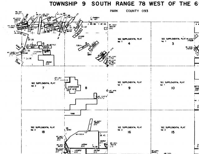
Sounds like it is the same thing that I researched prior to prospecting in the area now known as the Tonko #1 Placer Mining Claim. Here's a copy of the STATUS OF PUBLIC DOMAIN LAND AND MINERAL TITLES that I obtained from BLM many years ago. Please note that there aren't any county or forest service roads depicted on this plat but those roads certainly do exist and are currently in use.
Good advice from Clay Diggins. Thanks,
ASTROBLEME
|
Posted by: Clay Diggins Aug 20 2018, 10:23 PM
Sounds like it is the same thing that I researched prior to prospecting in the area now known as the Tonko #1 Placer Mining Claim. Here's a copy of the STATUS OF PUBLIC DOMAIN LAND AND MINERAL TITLES that I obtained from BLM many years ago. Please note that there aren't any county or forest service roads depicted on this plat but those roads certainly do exist and are currently in use.
Good advice from Clay Diggins. Thanks,
ASTROBLEME
|
|
Yes that is a portion of the Master Title Plat for your Township, as it says in the upper right side of each MTP. As I already pointed out you won't see roads or other physical features you will only see a ROW or easement, if one exists, for the road. There is no ROW or easement platted.
Here's an example of what a ROW looks like on a Master Title Plat:
|
If an MTP contains an error that error becomes the official land status until the error is corrected. All federal agencies and land users rely on the MTP, Supplements, and Historical Index to represent the official legal status of the depicted lands. The MTP is where the buck stops.
If you look closer at Sections 7 and 18 on the MTP you show you will notice there is no notation in those sections except for instructions to see the Supplemental Plat.
Supplemental Plats are used when there is too much detail in a Section to show on the full Township MTP. The Section is left empty on the MTP and the detail is shown only in the Supplemental Plat. The land status in Sections 7 and 18 is so complex they had to make separate Plat maps for each Section. A lot going on there.
For Section 7 you will need to download Supplemental Plat 2.
For Section 18 you will need to download Supplemental Plat 4.
I can see now why you would be confused by the land status there if you are relying on the MTP you show in your post. Without including the Supplements it appears there are no land status issues to consider in those Sections. Download the supplements and I'm sure that will explain the difference in our understanding of the land status in that area.
Posted by: ASTROBLEME Aug 21 2018, 09:12 AM
Everyone,
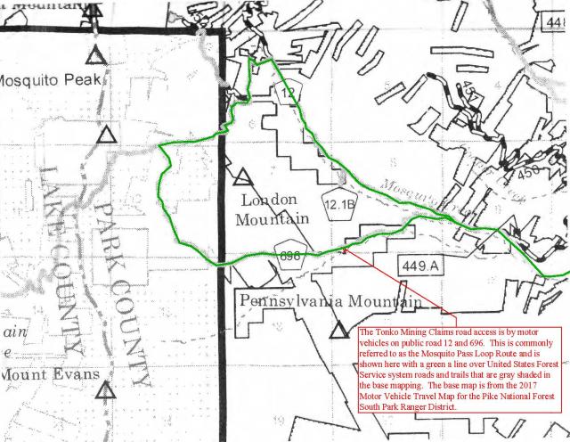
Here's a map that will help with understanding where the road is with respect to our claims.
ASTROBLEME
|
Posted by: ASTROBLEME Aug 22 2018, 05:21 PM
Everyone,
The road known as CR 696 is a county road open to the public and the closure problem has been addressed. This was confirmed by the Master Managers from the United States Forest Service and Park County Colorado government.
If you have difficulty in traveling CR 12 or CR 696 due to interference from any private lands owners, my experience with the following contacts was very positive. Both are knowledgeable with respect to this recurring problem and they have authority over this matter;
Josh Voorhis, District Ranger South Park Ranger District (719) 836-2031
Tom Eisenman, Park County Manager (719) 836-4203
Perhaps you'll get the chance to enjoy the coming fall season by taking a 4X4 road trip on the Mosquito Pass Loop. Hope to see you up on the mountain. 
ASTROBLEME
|
Posted by: Denise Aug 23 2018, 09:28 AM
Great information Clay Diggins and ASTROBLEME, thank you for sharing it with us. 
I appreciate your interaction very much!
Posted by: reinhold Aug 23 2018, 09:36 AM
The road known as CR 696 is a county road open to the public and the closure problem has been addressed. This was confirmed by the Master Managers from the United States Forest Service and Park County Colorado government.
If you have difficulty in traveling CR 12 or CR 696 due to interference from any private lands owners, my experience with the following contacts was very positive. Both are knowledgeable with respect to this recurring problem and they have authority over this matter;
Josh Voorhis, District Ranger South Park Ranger District (719) 836-2031
Tom Eisenman, Park County Manager (719) 836-4203
Perhaps you'll get the chance to enjoy the coming fall season by taking a 4X4 road trip on the Mosquito Pass Loop. Hope to see you up on the mountain.
ASTROBLEME
Thanks, Astrobleme! I had it on my list to call Park Cty ROW today, but I won't bug them now.
I also enjoyed your discussion with Clay -- learned a lot!
Posted by: ASTROBLEME Oct 11 2018, 05:28 PM
We have revised our asking price for the gold stockpile at London Mountain due to the changes in gold value, new information and the recent inquiries of our for sale offering.
The asking price for our 60 acre gold placer mining claim is now $2,300,00.00 (Two Million, Three Hundred Thousand U.S. Dollars).
While our asking price is negotiable, we feel that this is fair, given the consideration for the weighted average stated in the attached report of 0.19 opt, calculated using the estimated 172,000 tons in the stockpile, the math works out to be 32,680 ounces of gold.
Thanks to all those expressing interest in this offering to date. We hope that you find the price reduction appealing.

|
Posted by: ASTROBLEME Oct 16 2018, 06:42 PM
Most of the very high grade specimens have already been removed using modern hand held metal detectors. Even so, the stockpile has only been worked from the flat top and only detected to a depth of 18 " or so.
Here's an interesting link to a London Mountain gold specimen;
http://www.davebunkminerals.com/specimen.htm?id=777#.W8aEMvZFyUl
ASTROBLEME
Posted by: ASTROBLEME Jan 3 2019, 07:34 PM
ASKING PRICE UPDATE
We've had to rescinded our asking price for the gold stockpile at London Mountain due to the significant increases in gold value, consideration for the tremendous reduction in fuel costs for transport to mills and the recent uptick in responses for this sale offering.
Our asking price is now based upon real-time market conditions.
Sincerely,
Johnny Tonko
President
Tonko Mining Company, Inc.
johnny.tonko@tonkomining.com
Posted by: ASTROBLEME Jan 4 2019, 05:19 PM
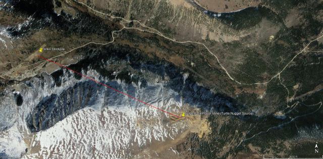
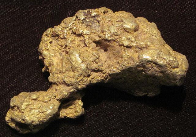
In 1938, there was a nugget mined from the Bulger Placer that weighed almost 1 troy pound. More recently, the Turtle Nugget (7.8 troy ounces) was found with a metal detector in the same placer. The source of these large specimens is only 1 1/2 miles southeast of the Tonko Stockpile.
ASTROBLEME
Vicinity Map
|
Turtle Nugget
|
Posted by: ASTROBLEME Feb 21 2019, 07:42 PM
Everyone,
I hope you'll find the attached report helpful as it details the geology, mining history and tenor of the ores being mined in the vicinity of the London Fault at a time when the high grade stockpile was being put into place by hand sorting ores from London Mine.
The London Mine research begins on page 44 of 93... but the entire document reveals the significance of precious and base metal resources in the area.
ASTROBLEME Ore_Deposits_in_the_Vicinity_of_London_Fault.pdf ( 9.04MB )
: 6181
Ore_Deposits_in_the_Vicinity_of_London_Fault.pdf ( 9.04MB )
: 6181
Posted by: ASTROBLEME Apr 22 2020, 07:01 PM
Thanks for the interest in this gold mining claim. In consideration of the current gold market trend, we hereby withdraw this "for sale" offering.
Sincerely,
Johnny F. Tonko
President
Tonko Mining Company, Inc.
Posted by: johnnybravo300 Jun 7 2020, 07:42 AM
I wouldnt sell it either!
It will be worth alot more in the next few years I bet. What hard rock miner wouldnt drool on himself seeing that big pile just sitting there ready to be processed!
Powered by Invision Power Board (http://www.invisionboard.com)
© Invision Power Services (http://www.invisionpower.com)