Arkansas River Pointbar |


 Colorado Prospector - Gem and mineral prospecting and mining forums > Prospecting, Mineral Collecting and Treasure Hunting Forums > Prospectors and Rockhounding Field Work
  |
Arkansas River Pointbar |
 Jun 11 2010, 11:57 AM Jun 11 2010, 11:57 AM
Post
#31
|
|
 Shovel Buster!  Group: Members Posts: 78 Joined: 30-June 08 From: Southwest,Oklahoma Member No.: 5,617 |
Does anyone know of a better map for the Arkansas headwater recreational area?
This leaves a lot to be desired. http://parks.state.co.us/Parks/ArkansasHea...Bro_Web2008.pdf |
 |
 
|
|
Jun 11 2010, 01:39 PM
Post
#32
|
|
 Master Mucker! Group: Admin Posts: 4,149 Joined: 7-October 03 From: Colorado Member No.: 3 |
I agree Jon, that map is not very helpful....darn it.
Since this is a "headwater" area we are talking about, I'd bet the actual boundries extend beyond and include private parcels and BLM lands but is about the water, it's ownership and the quality of the entire water table. Boundries of the area go a long ways from the Arkansas river itself. I think what might be of more help for you is the state wide (1:500,000 scale) BLM map. That map can be obtained directly from the BLM and shows land status/authorty (FS or BLM) and private ownership for the entire state, and it also shows the federal withdrawls associated with the Arkansas river headwater area stretching from just below Leadville to just above Canyon city. The federal withdrawls shown shaded in grey along the river itself I think will be more help for what you are working on. From that map you should be able to get a good idea where the recreational area withdrawls are plotted. Scale is large so you'll need to move to smaller scale maps for more details with that information too. The state map is a huge map but it looks killer hangin' on the wall.....if you have one big enough. My copy was printed in 1991, but I'd imagine there would be a more recent version available now. After checking to see if it would help out, mine got folded up and put back in the drawer again. 
-------------------- CP-Owner/Administrator
www.ColoradoProspector.com IF YOU USE IT, THE GROUND PRODUCED IT! MINERS MAKE "IT" HAPPEN!! |
|
|
|
|
Jun 11 2010, 05:44 PM
Post
#33
|
|
 Shovel Buster! Group: Members Posts: 206 Joined: 19-May 10 From: Longmont, Colorado Member No.: 7,248 |
QUOTE (OkieJon @ Jun 11 2010, 12:57 PM)  Does anyone know of a better map for the Arkansas headwater recreational area? This leaves a lot to be desired. http://parks.state.co.us/Parks/ArkansasHea...Bro_Web2008.pdf Jon, This page has maps of the campgrounds. It also has the map that you posted, so I don't know if this is exactly what your looking for. http://parks.state.co.us/Parks/ArkansasHea...Directions.aspx Boogie -------------------- peto metallum honestus
|
|
|
|
|
Jun 11 2010, 05:45 PM
Post
#34
|
|
|
Shovel Buster! Group: Members Posts: 206 Joined: 19-May 10 From: Longmont, Colorado Member No.: 7,248 |
Good. I'm glad this ugly mess is over.
Boogie -------------------- peto metallum honestus
|
|
|
|
|
Jun 11 2010, 06:13 PM
Post
#35
|
|
|
Shovel Buster! Group: Members Posts: 78 Joined: 30-June 08 From: Southwest,Oklahoma Member No.: 5,617 |
QUOTE (Boogie @ Jun 11 2010, 05:45 PM) Good. I'm glad this ugly mess is over. Boogie Sometimes it good for someone to go a little off topic. ; ) Thanks for the link. I am looking for an exact boundary of the land put aside for the Arkansas Headwaters Receration Area...The place I am wanting to claim is near hwy 50,but not on the river. Just trying to do some homework before I come to Co.My efforts have been fruitless!lol |
|
|
|
|
Jun 11 2010, 07:14 PM
Post
#36
|
|
 Rock Bar! Group: Members Posts: 613 Joined: 16-October 08 From: Central Colorado Member No.: 6,813 |
QUOTE (OkieJon @ Jun 11 2010, 11:25 AM) The claimant from Texas still holds 6 of the 7 claims. Is was my understand that a single person could only file 20 acres(placer) What am I mis-understanding? Hi OkieJon, With respect to placer claim size, several claimants can get together and file a claim with a size up to 20 acres for each claimant. As an example, under Colorado law, up to 8 people can partner together and stake one claim that is up to 160 acres in size. There were two claimants from Texas staking the Point Bar vicinity beginning in 2009; hence each individual was allowed to claim 20 acres, so with both of them listed as claimants, each one of their claims was up to a maximum 40 acres in size. Hope this helps clarify any misunderstanding. ASTROBLEME -------------------- Annual Dues Paying Member Since 2008
Tonko Mining Company "Some day this crater is going to be a greatly talked about place, and if the above credit is due, as is certainly the case, I would like to have it generally known for the sake of the children." Daniel Moreau Barringer 2/1/1912 in a letter about the Barringer Meteorite Crater, Arizona USA |
|
|
|
|
Jun 11 2010, 10:41 PM
Post
#37
|
|
|
Shovel Buster! Group: Members Posts: 206 Joined: 19-May 10 From: Longmont, Colorado Member No.: 7,248 |
QUOTE (OkieJon @ Jun 11 2010, 12:57 PM) Does anyone know of a better map for the Arkansas headwater recreational area? This leaves a lot to be desired. http://parks.state.co.us/Parks/ArkansasHea...Bro_Web2008.pdf Jon, My internet is super slow tonight. I'm not able to view the maps at this link because of connection. There is a planning and zoning map on the this page. Not sure how useful any of these maps are. Probably useless. Use at own risk. http://mappery.com/Arkansas-Headwaters-Recreation-Area-map Boogie -------------------- peto metallum honestus
|
|
|
|
|
Jun 13 2010, 08:59 PM
Post
#38
|
|
|
Shovel Buster! Group: Members Posts: 78 Joined: 30-June 08 From: Southwest,Oklahoma Member No.: 5,617 |
Boogie, Thanks for the link. It was not what I was looking for but those maps will come in handy!
|
|
|
|
|
Jun 14 2010, 06:44 AM
Post
#39
|
||||||
 Master Mucker Group: Members Posts: 1,439 Joined: 22-February 04 Member No.: 98 |
OkieJohn, give me the locations you want maps of and I'll see what I can do.
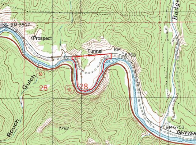
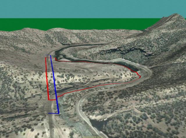
As for Point Bar.... Using the map provided earlier, I tried my best at guestimating. Having actual coordinates helps a lot. The red line is the estimated claim boundary and the blue line is the mandatory right of way owned outright by the railroad. That is 100' from center of the railroad on each side. They can claim it all they want, but the railroad is gonna laugh their butts off at those guys if they think they can beat the railroad! On top of that, I never heard of placer claims following a physical feature, in this case the river. Something tells me them Texas fellas don't know jack squat, or they are doing this for the real estate value, and not mining.
Attached thumbnail(s)
-------------------- Today's socio-political climate is rock solid proof that Adam and Eve weren't prospectors.
If they were they'd have eaten the snake instead of the apple and we'd still be in heaven.... |
|||||
|
|
|
|||||
|
Jun 14 2010, 07:04 AM
Post
#40
|
|
|
Master Mucker Group: Members Posts: 1,439 Joined: 22-February 04 Member No.: 98 |
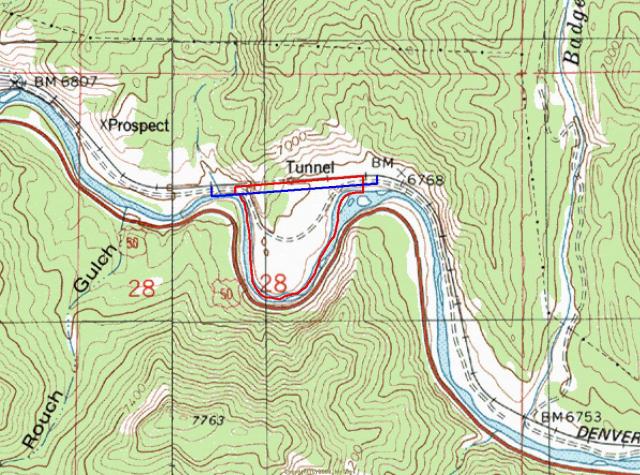
And you can see the errors of guestimating. Everything looked good on the map. But transposed onto the aerials, not good.
-------------------- Today's socio-political climate is rock solid proof that Adam and Eve weren't prospectors.
If they were they'd have eaten the snake instead of the apple and we'd still be in heaven.... |
|
|
|
|
Jun 14 2010, 07:34 AM
Post
#41
|
|
|
Shovel Buster! Group: Members Posts: 78 Joined: 30-June 08 From: Southwest,Oklahoma Member No.: 5,617 |
Coalbunny,
I will send you a pm. Jon |
|
|
|
|
Jun 14 2010, 12:13 PM
Post
#42
|
|
|
Shovel Buster! Group: Members Posts: 78 Joined: 30-June 08 From: Southwest,Oklahoma Member No.: 5,617 |
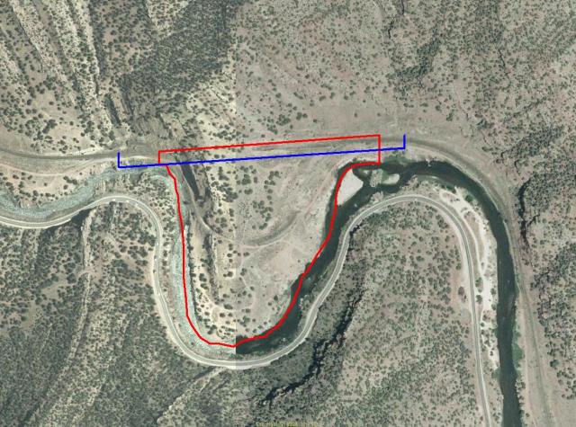
Ok...I may have finally figured part of this out.Good thing I have 3 day weekends as it took all three.
Below is a part of the Arkansas River below Buena Vista. The green lines around/by the river are part of the Ar Headwaters recreation area and not open to mineral claims....I think. 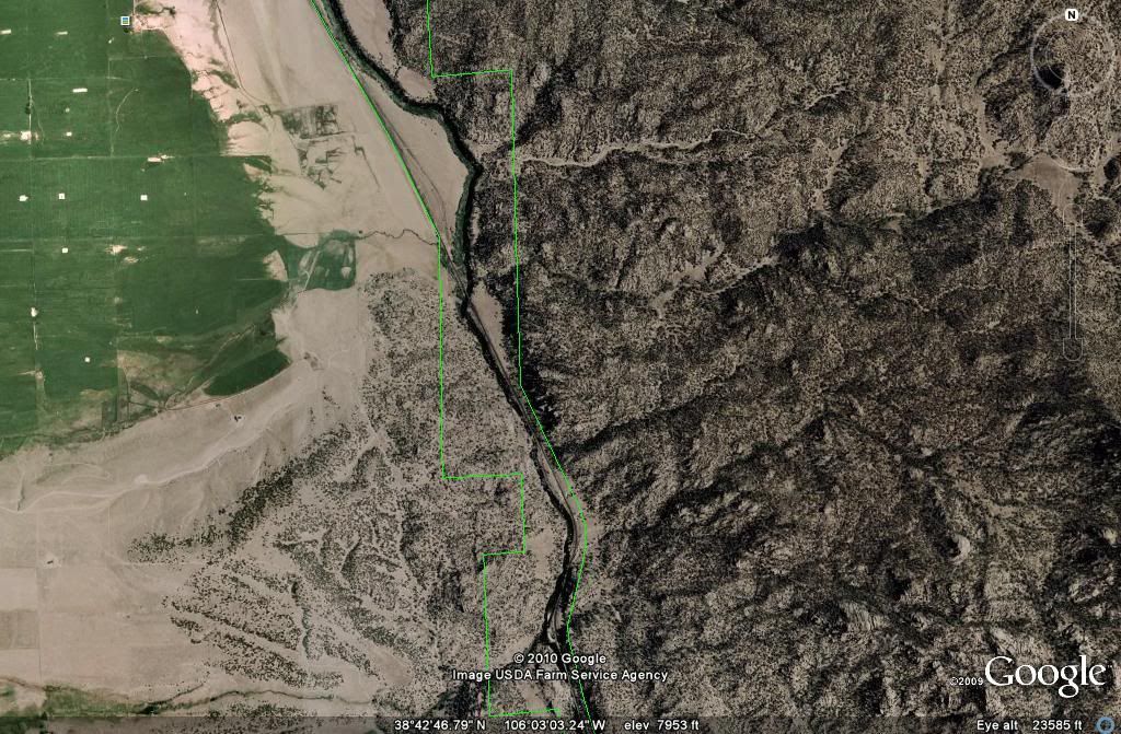
|
|
|
|
|
Jun 14 2010, 12:27 PM
Post
#43
|
|
|
Shovel Buster! Group: Members Posts: 78 Joined: 30-June 08 From: Southwest,Oklahoma Member No.: 5,617 |
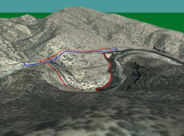
Another image from above the river.The blurry blue to the north is just part of a program I have.
One can see,they not only took alot of the river,but plenty more of the land. 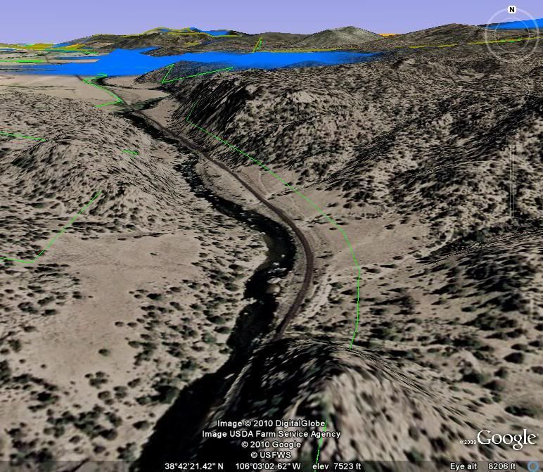
|
|
|
|
|
Jun 14 2010, 04:20 PM
Post
#44
|
||
|
Rock Bar! Group: Members Posts: 613 Joined: 16-October 08 From: Central Colorado Member No.: 6,813 |
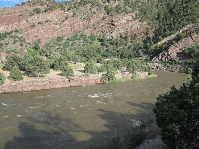
Here's a recent photo of the Point Bar Recreational Site. Flows were 3,700 cfs and there were still a few folks working the area.
-------------------- Annual Dues Paying Member Since 2008
Tonko Mining Company "Some day this crater is going to be a greatly talked about place, and if the above credit is due, as is certainly the case, I would like to have it generally known for the sake of the children." Daniel Moreau Barringer 2/1/1912 in a letter about the Barringer Meteorite Crater, Arizona USA |
|
|
|
|
|
|
Jul 4 2010, 07:15 AM
Post
#45
|
||
|
Observer Group: Members Posts: 2 Joined: 4-July 10 Member No.: 7,299 |
QUOTE (ASTROBLEME @ Jun 14 2010, 05:20 PM) Here's a recent photo of the Point Bar Recreational Site. Flows were 3,700 cfs and there were still a few folks working the area.
Does the gold in the high banking area continue into the river at point bar? |
|
|
|
|
|
|
| Lo-Fi Version | Time is now: 18th April 2024 - 06:07 AM |