Montezuma's Treasure Vault?, Stone Ruins Discovered While Prospecting |


 Colorado Prospector - Gem and mineral prospecting and mining forums > Prospecting, Mineral Collecting and Treasure Hunting Forums > Treasure Hunting and Metal Detecting
Montezuma's Treasure Vault?, Stone Ruins Discovered While Prospecting |
 Jan 24 2015, 01:43 PM Jan 24 2015, 01:43 PM
Post
#1
|
||
 Rock Bar!  Group: Members Posts: 613 Joined: 16-October 08 From: Central Colorado Member No.: 6,813 |
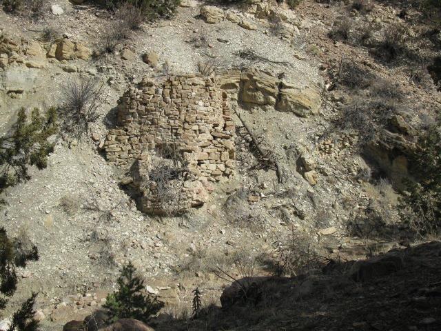
My wife and I discovered an ancient stone ruins site while prospecting for gold back in 2013.
The site consists of three structures that are constructed onto the natural steep slope of the side of a dry arroyo leading down to a river a few miles away. A query to U.S. Department of Interior returns no knowledge of any previous investigation or other documentation of this site. My first impression was that it may have been a mining or homestead site, a kiln or storage area in the shelter of the arroyo. After looking it over closely, it was apparent that it was built long ago due to the 10 foot depth of erosion observed from the base of the structures to the present bottom of the channel. There isnt a historic wagon road or trail to the site. There is no near source of water. It appeared to me to resemble the cliff dwellings in SW Colorado more than anything else Ive seen. The largest of the ruins is a round structure of crude unshaped natural stone blocks, essentially forming a tower with a solid flat top. The mortar material of the 'tower' and the smaller rectangular structures nearby appears to be a kind of course cement made up of pebbles and gravel found locally. The possible ceremonial aspect that gets my attention is the platform at the base that points towards a notch in the horizon at 245 degree (m), the near angle of the summer solstice sunset. There is a possibility that the tower covers an underground tunnel dug into the soft siltstone-shale that forms the bank of the arroyo. The structures might have been covered over after being built by simply pushing down the steep slope some of the fill and alluvial materials found uphill of the ruins. There is still much to be learned at this site and I would appreciate any ideas that you might have. Presently, I am looking into the possibility that these stone ruins may have been constructed by one of the 7 caravans that traveled north with Montezumas Aztec Treasure. For sure, the Conquistadors were present in this area spanning many decades after Cortezs activity in present day Mexico.
-------------------- Annual Dues Paying Member Since 2008
Tonko Mining Company "Some day this crater is going to be a greatly talked about place, and if the above credit is due, as is certainly the case, I would like to have it generally known for the sake of the children." Daniel Moreau Barringer 2/1/1912 in a letter about the Barringer Meteorite Crater, Arizona USA |
|
 |
 
|
|
 |
|
Feb 25 2019, 07:57 PM
Post
#2
|
|||
|
Rock Bar! Group: Members Posts: 613 Joined: 16-October 08 From: Central Colorado Member No.: 6,813 |
Hi Everyone,
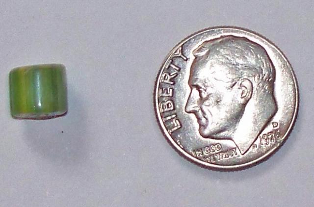
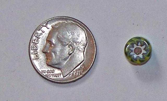
It's been a few years since I've posted anything new on this thread. I hope you find this update interesting. My archaeologist friend found a bead that eroded from the steep creek bank at the Tower site. He sent me these photos;
I'm thinking that it is possible that this "green" trade bead is associated with Chief Cuerno Verde (translated from Spanish to Greenhorn). The Spanish named him, Cuerno Verde because of his remarkable bison-horned headdress. In late October of 1768, 500 Comanches attacked Ojo Caliente before dawn attempting to wipe out all the Spaniards. During the attack the Spanish killed the Comanches charismatic leader, Cuerno Verde in the town square. The chiefs son, Tabivo Naritgant took his father's name and dedicated himself to killing Spaniards in revenge. His given name was Tabivo Naritgant, or "Dangerous Man." He received his distinctive leather headdress with green-tinted buffalo horns from his father. Comanche beliefs bound Cuerno Verdes family to avenge his death. Juan Bautista de Anza chased after him. Cuerno Verdes distinctive headdress was claimed by Anza. He sent it to Teodoro de Croix, the first commandant general of the Northern section of New Spain. According to legend, it was forwarded to his superiors who eventually sent it to the Vatican, where it still may be buried in the Library. No one has found artifacts to prove the actual location of the battle between Anza and Cuerno Verde. Wilfred O. Martinez (a descendant of Bernardo Miera y Pacheco, the mapmaker for Anzas campaign) believes the site is 18 miles south of Pueblo near the Burnt Mill Road Bridge over the St. Charles River (Rio San Carlos). He thinks others had been misled by a bad translation of zanja. They thought it meant bog or swamp, when it fact its an arroyo. The monument in Greenhorn Park was moved there from another location west and closer to Greenhorn Creek. It is unlikely that it marks the exact location of the battle. The history noted above was part of the documentation from this source; Story of the Greenhorn Sincerely, ASTROBLEME -------------------- Annual Dues Paying Member Since 2008
Tonko Mining Company "Some day this crater is going to be a greatly talked about place, and if the above credit is due, as is certainly the case, I would like to have it generally known for the sake of the children." Daniel Moreau Barringer 2/1/1912 in a letter about the Barringer Meteorite Crater, Arizona USA |
||
|
|
|
||
 ASTROBLEME Montezuma's Treasure Vault? Jan 24 2015, 01:43 PM
 fenixsmom That is so freaking cool! Jan 24 2015, 02:08 PM fenixsmom Lol I was going to show off my lil archaeological ... Jan 24 2015, 02:12 PM ColoradoProspector Very cool find you two! It will be very exci... Jan 24 2015, 02:38 PM fenixsmom Is there any sort of mortar in-between the cobbles... Jan 24 2015, 02:49 PM
 ASTROBLEME QUOTE (fenixsmom @ Jan 24 2015, 01:49 PM)... Jan 24 2015, 03:57 PM ASTROBLEME Here's a pic looking down channel. This gives... Jan 24 2015, 03:21 PM Crusty What an amazing find! Goes to show how much co... Jan 24 2015, 03:37 PM ASTROBLEME The source for the mortar is in the near vicinity.... Jan 24 2015, 03:38 PM ASTROBLEME To give you an idea as to the size/scale of the st... Jan 24 2015, 04:08 PM Rockyrat First off this is very cool. I originally came acr... Jan 24 2015, 04:32 PM ASTROBLEME QUOTE (Rockyrat @ Jan 24 2015, 03:32 PM) ... Jan 24 2015, 05:38 PM ASTROBLEME Dear Treasure Seekers,
You may know something abo... Jan 24 2015, 07:38 PM RhodoRose 'Morning!
My interest in archeology used ... Jan 25 2015, 09:00 AM ASTROBLEME QUOTE (RhodoRose @ Jan 25 2015, 08:00 AM)... Jan 25 2015, 12:35 PM fenixsmom If I'm not mistaken, the only civilizations th... Jan 25 2015, 11:46 AM fenixsmom Of course, heed warning to Rhodo! If you find ... Jan 25 2015, 11:48 AM fenixsmom Sorry for trying to help. Maybe you should contact... Jan 25 2015, 02:56 PM swizz QUOTE (fenixsmom @ Jan 25 2015, 01:56 PM)... Jan 25 2015, 03:13 PM RhodoRose Totally understand, Astro, Thank-you for clarifyin... Jan 25 2015, 04:09 PM ASTROBLEME Here is a photo of the top of the "tower... Jan 25 2015, 06:22 PM RhodoRose I agree - it does look like the entrance to a tunn... Jan 25 2015, 10:21 PM Coalbunny Jessie, Aztec & Mayans were in Mexico & So... Jan 26 2015, 01:13 AM fenixsmom Thanks Coalbunny! I always thought Colorado me... Jan 26 2015, 09:24 AM Coalbunny QUOTE (fenixsmom @ Jan 26 2015, 08:24 AM)... Jan 26 2015, 10:43 PM fenixsmom I had a thought yesterday. (watch out!) Is the... Jan 26 2015, 09:42 AM Woody Cool Thread! Possibilities abound. Wish I woul... Jan 26 2015, 11:14 AM Crusty WOODY! Good to hear from you; hope all is well... Jan 26 2015, 12:01 PM ASTROBLEME Another photo of the tower...this shows the rounde... Jan 26 2015, 07:42 PM ASTROBLEME Everyone,
Ive observed a line of man-made holes ... Feb 9 2015, 11:47 PM MikeS The tower and the holes surely look man-made to me... Feb 10 2015, 12:33 AM ASTROBLEME Everyone who is following this,
I want to thank ... Feb 10 2015, 09:44 PM fenixsmom Ahh. Now I see why you posted it's location. T... Feb 10 2015, 10:28 PM ASTROBLEME There will be a tour of the stone ruins site that ... Feb 12 2015, 06:23 PM RhodoRose Thanks for the info, Astro - it just so happens I... Feb 12 2015, 11:16 PM ASTROBLEME QUOTE (RhodoRose @ Feb 12 2015, 10:16 PM)... Feb 13 2015, 09:10 AM Mrs.CP You are top notch Johnny!! What a fant... Feb 15 2015, 02:49 PM ASTROBLEME On the tour, I found broken pottery that appeared ... Feb 20 2015, 07:55 PM ColoradoProspector It is a penny!
Interesting to find more pie... Feb 21 2015, 05:36 PM
ASTROBLEME QUOTE (fenixsmom @ Jan 24 2015, 01:49 PM)... Jan 24 2015, 03:57 PM ASTROBLEME Here's a pic looking down channel. This gives... Jan 24 2015, 03:21 PM Crusty What an amazing find! Goes to show how much co... Jan 24 2015, 03:37 PM ASTROBLEME The source for the mortar is in the near vicinity.... Jan 24 2015, 03:38 PM ASTROBLEME To give you an idea as to the size/scale of the st... Jan 24 2015, 04:08 PM Rockyrat First off this is very cool. I originally came acr... Jan 24 2015, 04:32 PM ASTROBLEME QUOTE (Rockyrat @ Jan 24 2015, 03:32 PM) ... Jan 24 2015, 05:38 PM ASTROBLEME Dear Treasure Seekers,
You may know something abo... Jan 24 2015, 07:38 PM RhodoRose 'Morning!
My interest in archeology used ... Jan 25 2015, 09:00 AM ASTROBLEME QUOTE (RhodoRose @ Jan 25 2015, 08:00 AM)... Jan 25 2015, 12:35 PM fenixsmom If I'm not mistaken, the only civilizations th... Jan 25 2015, 11:46 AM fenixsmom Of course, heed warning to Rhodo! If you find ... Jan 25 2015, 11:48 AM fenixsmom Sorry for trying to help. Maybe you should contact... Jan 25 2015, 02:56 PM swizz QUOTE (fenixsmom @ Jan 25 2015, 01:56 PM)... Jan 25 2015, 03:13 PM RhodoRose Totally understand, Astro, Thank-you for clarifyin... Jan 25 2015, 04:09 PM ASTROBLEME Here is a photo of the top of the "tower... Jan 25 2015, 06:22 PM RhodoRose I agree - it does look like the entrance to a tunn... Jan 25 2015, 10:21 PM Coalbunny Jessie, Aztec & Mayans were in Mexico & So... Jan 26 2015, 01:13 AM fenixsmom Thanks Coalbunny! I always thought Colorado me... Jan 26 2015, 09:24 AM Coalbunny QUOTE (fenixsmom @ Jan 26 2015, 08:24 AM)... Jan 26 2015, 10:43 PM fenixsmom I had a thought yesterday. (watch out!) Is the... Jan 26 2015, 09:42 AM Woody Cool Thread! Possibilities abound. Wish I woul... Jan 26 2015, 11:14 AM Crusty WOODY! Good to hear from you; hope all is well... Jan 26 2015, 12:01 PM ASTROBLEME Another photo of the tower...this shows the rounde... Jan 26 2015, 07:42 PM ASTROBLEME Everyone,
Ive observed a line of man-made holes ... Feb 9 2015, 11:47 PM MikeS The tower and the holes surely look man-made to me... Feb 10 2015, 12:33 AM ASTROBLEME Everyone who is following this,
I want to thank ... Feb 10 2015, 09:44 PM fenixsmom Ahh. Now I see why you posted it's location. T... Feb 10 2015, 10:28 PM ASTROBLEME There will be a tour of the stone ruins site that ... Feb 12 2015, 06:23 PM RhodoRose Thanks for the info, Astro - it just so happens I... Feb 12 2015, 11:16 PM ASTROBLEME QUOTE (RhodoRose @ Feb 12 2015, 10:16 PM)... Feb 13 2015, 09:10 AM Mrs.CP You are top notch Johnny!! What a fant... Feb 15 2015, 02:49 PM ASTROBLEME On the tour, I found broken pottery that appeared ... Feb 20 2015, 07:55 PM ColoradoProspector It is a penny!
Interesting to find more pie... Feb 21 2015, 05:36 PM |
| Lo-Fi Version | Time is now: 21st May 2024 - 09:23 AM |