GOLD MINING CLAIM near Fairplay Colorado FOR SALE, High Grade Ore Stockpile from London Mine and Placer Grounds |


 Colorado Prospector - Gem and mineral prospecting and mining forums > Miners Crafts, Goods & Classified ads > Wanted > SOLD or Found!
GOLD MINING CLAIM near Fairplay Colorado FOR SALE, High Grade Ore Stockpile from London Mine and Placer Grounds |
 Jan 5 2018, 06:58 PM Jan 5 2018, 06:58 PM
Post
#1
|
|||||
 Rock Bar!  Group: Members Posts: 613 Joined: 16-October 08 From: Central Colorado Member No.: 6,813 |
NOTICE:
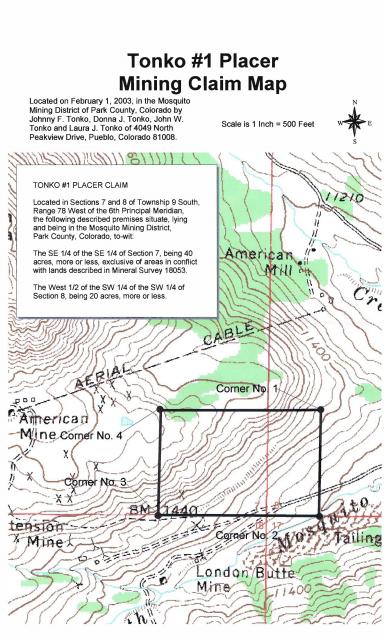
Due to the high grade nature of the gold ore stockpiled on this claim,the area is patrolled and monitored. This Federal Mining Claim is located, recorded, and maintained in accordance with 43 C.F.R. Part 3800 and 30 U.S.C. 22 et seq.; 43 U.S.C. 1744 and all appropriate state laws. All persons are warned that disturbance of the monuments, surface, or improvements on this claim or removal of minerals of any type without permission of the claimant(s), will result in their prosecution under the appropriate state and federal statutes. HISTORY: The London Mine Group was developed on pollymetallic quartz veins associated with the Great London Fault. According to documentation by Singewald and Butler (1941) the ore mined between 1895 and 1910 averaged 2.895 opt gold, 2.858 opt silver, 4.13 % lead, 2.66 % zinc, 4.85 % iron, 6.11 % sulfur, and 76.8 % silicon. The most recent reports published by the Colorado Geological Survey state that remaining mine and stockpile resources range from 0.10 to 0.41 opt gold having a weighted average of 0.19 opt gold. Most of the Tonko #1 CMC289770 mining claim was formerly known as the Jewett #1 CMC94664 and the Jewett #2 CMC94665 mining claims that were held by London Mine Venture from 1935 through 1991. The stockpile on Tonko #1 was estimated by Behre Dolbear & Company, Inc. in a report dated March of 1985 to contain 172,000 tons of gold ore! MINING CLAIM MAP:
GOOGLE EARTH VIEW OF CLAIM:
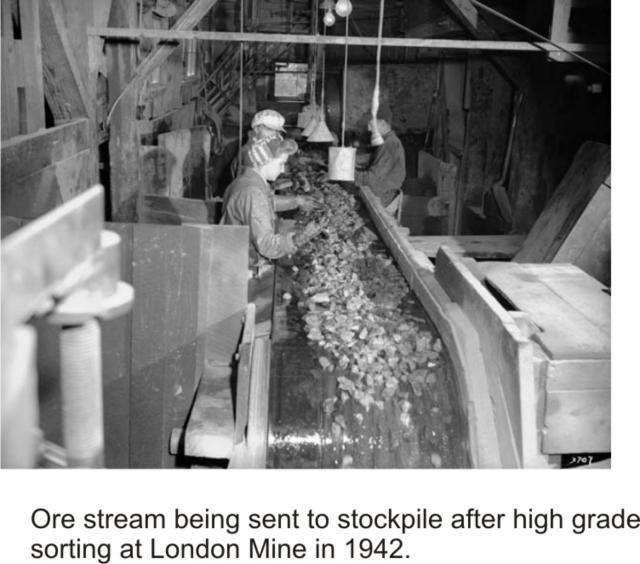
HIGH GRADE SORTING OF ORE: This photo shows the limited number of employees hand sorting out the exceptionally high grade ore being transported from the mine. Only the highest grades of visible gold ore were hand picked off of the conveyor belt and shipped out for processing. The mine had taken out all processing equipment after World War I due to high taxation. The gold ore stockpile was created by using a small mining train that traveled about 1/4 mile uphill from the sorting facility and dumped along the mountainside for future processing. The round-trip for stockpiling was about 1/2 mile and the volume of ore that was stored now looms over the local area. Since the hand sorting crew wore thick gloves and the speed of the conveyor belt moved exceptional specimens right past the sorting crew, substantial volumes of exceptionally high grade ore was subsequently transported out to the stockpile.
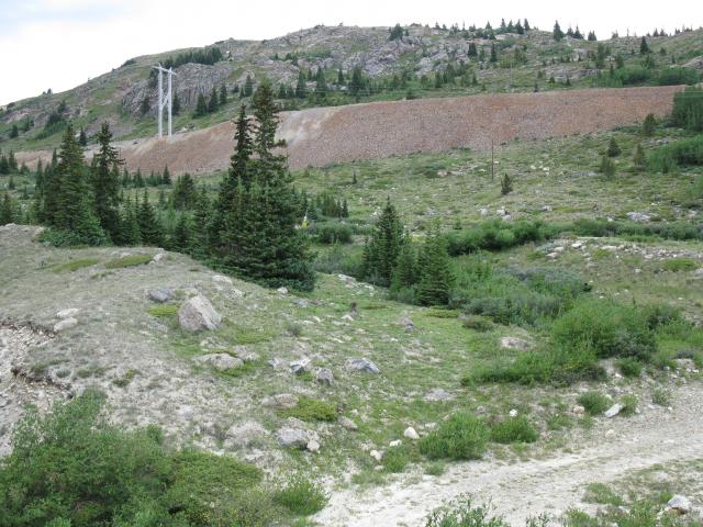
STOCKPILE PHOTO:
CONTACT: President of Tonko Mining Company, Inc. -------------------- Annual Dues Paying Member Since 2008
Tonko Mining Company "Some day this crater is going to be a greatly talked about place, and if the above credit is due, as is certainly the case, I would like to have it generally known for the sake of the children." Daniel Moreau Barringer 2/1/1912 in a letter about the Barringer Meteorite Crater, Arizona USA |
||||
 |
 
|
||||
 |
|
Aug 19 2018, 06:05 PM
Post
#2
|
|
|
Rock Bar! Group: Members Posts: 613 Joined: 16-October 08 From: Central Colorado Member No.: 6,813 |
Clay Diggins,
Yesterday you wrote this in support of your position on the matter; "Interestingly the Master Title Plat doesn't indicate a ROW or easement where the road crosses the federally managed lands. That makes things rather ambiguous as far as a right to access the road despite the county and forest designations. That's why you are likely to get a shrug from the Sheriff." It's been my experience that the Master Title Plats and BLM records in general can have errors and omissions or otherwise be incorrect. ASTROBLEME -------------------- Annual Dues Paying Member Since 2008
Tonko Mining Company "Some day this crater is going to be a greatly talked about place, and if the above credit is due, as is certainly the case, I would like to have it generally known for the sake of the children." Daniel Moreau Barringer 2/1/1912 in a letter about the Barringer Meteorite Crater, Arizona USA |
|
|
|
|
Aug 20 2018, 02:03 AM
Post
#3
|
|
|
Shovel Buster! Group: Members Posts: 107 Joined: 23-September 14 Member No.: 118,169 |
QUOTE (ASTROBLEME @ Aug 19 2018, 06:05 PM)  Clay Diggins, Yesterday you wrote this in support of your position on the matter; "Interestingly the Master Title Plat doesn't indicate a ROW or easement where the road crosses the federally managed lands. That makes things rather ambiguous as far as a right to access the road despite the county and forest designations. That's why you are likely to get a shrug from the Sheriff." What's a "Master Title Plat"? Thanks, ASTROBLEME The Master Title Plat (MTP) is the map the federal government maintains of land status for every Township of land in the public land states. The Master Title Plat, Supplements and Historical Index together contain the entire history, as well as current status, of all the public lands. This includes things like patents, withdrawals, easements, ROWs, land orders, land sales, surveys, government lots, mineral surveys, proclaimed and Weeks Act Forests, National Monuments, National Parks, Grasslands and Seashores, National Recreation Areas, Wild and Scenic Rivers and just about any other change in status from the original free and open public domain land status. The MTP is not a "map" in the typical sense because it shows no natural features. The base unit is the surveyed or protracted PLSS so there is a recognizable grid to help you relate the MTP features with objects from more traditional maps. You won't see stream beds, roads or mountains on an MTP but you will see any related land status boundary definitions and notations. A stream bed that has been designated as a Scenic or Recreational withdrawal will show the boundaries of that withdrawal. A road that has a valid easement or ROW will show the physical extent of that right of way but not the road itself. ETC. You can see which patents were granted with reservations and generally what those reservations are. By following up with the Supplements (if there are any) and Historical Index research you can find out not only the current status of any portion of the public lands but the entire history of any actions that affected land status in the past. The MTP uses a unique notation rather than plain English to define the depicted areas. Since many different land status assignments can overlap each other the density of information would be very confusing if it were presented in longhand. There is a certain amount of memorization, practice and a firm grounding in the principles of surveys, patents and status interactions needed to get a full understanding of these records but an intelligent person like yourself could spend a few hours studying the basics to get enough knowledge to get a pretty good grasp on the status in a small area. The information on the MTP, Supplements, and Historical Index together are the legal definition of federal land status. They override all other maps, documents and Federal government agency records. This stuff is important to understand for anyone dealing with specific portions of the public lands. When I am researching an area for a project on public lands the very first information I study is the MTP, Supplements and Historical Index. If the land is open to the type of project involved I will then proceed to work on the actual project. If the land is closed to that type of project I know any more work wold be futile. At this point I would usually point you to the resources I've helped to make available to the public. Since that can't happen here I will point you to the source material and with more work you can get the same results. All Federal land records are supposed to be archived and available at the General Land Office (GLO). Although not all records are yet available there Colorado is pretty well covered. Any Colorado MTP, Supplement or Historical Index is available at GLO as well as copies of most patents etc. There may be as many as a million records available in Colorado alone. For your particular Township you will need the MTP and Supplement 4 (covers in detail where the claim/patent is) to get started. Historical Indexes can be very confusing until you get the hang of them so you might want to look those over after you learn to read the MTP. There are some tutorials and videos on reading MTPs available. An internet search should provide you with some links to those materials. Such a simple and rarely heard phrase - "Master Title Plat". This is a very deep and informative pond you have dipped your toe into. Enjoy the swim! 
|
|
|
|
|
Aug 20 2018, 06:19 AM
Post
#4
|
||
|
Rock Bar! Group: Members Posts: 613 Joined: 16-October 08 From: Central Colorado Member No.: 6,813 |
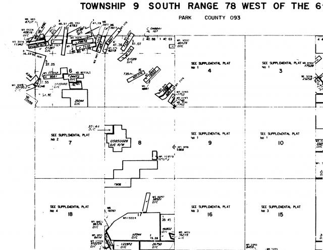
QUOTE (Clay Diggins @ Aug 20 2018, 03:03 AM) The Master Title Plat (MTP) is the map the federal government maintains of land status for every Township of land in the public land states. The Master Title Plat, Supplements and Historical Index together contain the entire history, as well as current status, of all the public lands. This includes things like patents, withdrawals, easements, ROWs, land orders, land sales, surveys, government lots, mineral surveys, proclaimed and Weeks Act Forests, National Monuments, National Parks, Grasslands and Seashores, National Recreation Areas, Wild and Scenic Rivers and just about any other change in status from the original free and open public domain land status. The MTP is not a "map" in the typical sense because it shows no natural features. The base unit is the surveyed or protracted PLSS so there is a recognizable grid to help you relate the MTP features with objects from more traditional maps. You won't see stream beds, roads or mountains on an MTP but you will see any related land status boundary definitions and notations. A stream bed that has been designated as a Scenic or Recreational withdrawal will show the boundaries of that withdrawal. A road that has a valid easement or ROW will show the physical extent of that right of way but not the road itself. ETC. You can see which patents were granted with reservations and generally what those reservations are. By following up with the Supplements (if there are any) and Historical Index research you can find out not only the current status of any portion of the public lands but the entire history of any actions that affected land status in the past. The MTP uses a unique notation rather than plain English to define the depicted areas. Since many different land status assignments can overlap each other the density of information would be very confusing if it were presented in longhand. There is a certain amount of memorization, practice and a firm grounding in the principles of surveys, patents and status interactions needed to get a full understanding of these records but an intelligent person like yourself could spend a few hours studying the basics to get enough knowledge to get a pretty good grasp on the status in a small area. The information on the MTP, Supplements, and Historical Index together are the legal definition of federal land status. They override all other maps, documents and Federal government agency records. This stuff is important to understand for anyone dealing with specific portions of the public lands. When I am researching an area for a project on public lands the very first information I study is the MTP, Supplements and Historical Index. If the land is open to the type of project involved I will then proceed to work on the actual project. If the land is closed to that type of project I know any more work wold be futile. At this point I would usually point you to the resources I've helped to make available to the public. Since that can't happen here I will point you to the source material and with more work you can get the same results. All Federal land records are supposed to be archived and available at the General Land Office (GLO). Although not all records are yet available there Colorado is pretty well covered. Any Colorado MTP, Supplement or Historical Index is available at GLO as well as copies of most patents etc. There may be as many as a million records available in Colorado alone. For your particular Township you will need the MTP and Supplement 4 (covers in detail where the claim/patent is) to get started. Historical Indexes can be very confusing until you get the hang of them so you might want to look those over after you learn to read the MTP. There are some tutorials and videos on reading MTPs available. An internet search should provide you with some links to those materials. Such a simple and rarely heard phrase - "Master Title Plat". This is a very deep and informative pond you have dipped your toe into. Enjoy the swim! Everyone, Sounds like it is the same thing that I researched prior to prospecting in the area now known as the Tonko #1 Placer Mining Claim. Here's a copy of the STATUS OF PUBLIC DOMAIN LAND AND MINERAL TITLES that I obtained from BLM many years ago. Please note that there aren't any county or forest service roads depicted on this plat but those roads certainly do exist and are currently in use. Good advice from Clay Diggins. Thanks, ASTROBLEME
-------------------- Annual Dues Paying Member Since 2008
Tonko Mining Company "Some day this crater is going to be a greatly talked about place, and if the above credit is due, as is certainly the case, I would like to have it generally known for the sake of the children." Daniel Moreau Barringer 2/1/1912 in a letter about the Barringer Meteorite Crater, Arizona USA |
|
|
|
|
|
 ASTROBLEME GOLD MINING CLAIM near Fairplay Colorado FOR SALE Jan 5 2018, 06:58 PM
 GoldenSilva How much is this Claim? Also, do you know of more ... Jan 6 2018, 02:15 AM ASTROBLEME The most recent gold mining activity near Fairplay... Jan 6 2018, 05:51 PM Crusty Wow, another amazing Tonko claim. Good luck with y... Jan 6 2018, 06:51 PM ASTROBLEME In 2001, the Colorado Geological Survey published ... Jan 10 2018, 11:52 AM Crusty Was great to finally meet the infamous Johnny Tonk... Jan 10 2018, 03:44 PM ASTROBLEME For further consideration in this matter, the ... Jan 10 2018, 06:03 PM dino27 please see table of bulk sampling results from Beh... Jan 11 2018, 10:46 AM
 ASTROBLEME QUOTE (dino27 @ Jan 11 2018, 09:46 AM) pl... Jan 11 2018, 11:32 AM Denise Dean, do not enter this community trying to cause ... Jan 11 2018, 12:01 PM Denise My pleasure Dean! Jan 11 2018, 12:47 PM ASTROBLEME I had some requests for pics so I'm sharing th... Jan 11 2018, 09:11 PM Gene Kooper QUOTE (ASTROBLEME @ Jan 11 2018, 08:11 PM... Jan 12 2018, 04:34 AM Gene Kooper GeoMatt,
I too am disappointed at the above respo... Jan 12 2018, 04:45 AM Denise Gene, I stand by what I said. It was obvious that ... Jan 12 2018, 09:19 AM ASTROBLEME Please understand that the report I'm quoting ... Jan 12 2018, 10:10 AM ASTROBLEME Here's the math...
The newest data presented ... Jan 14 2018, 11:03 AM Gene Kooper I didn't realize that two "PG"s coul... Jan 14 2018, 04:26 PM ASTROBLEME Everyone,
I would encourage you to do your own re... Jan 14 2018, 05:09 PM GeoMatt QUOTE (ASTROBLEME @ Jan 14 2018, 05:09 PM... Jan 17 2018, 09:55 AM EMac Johnny - best of luck in your endeavors sir.
Deni... Jan 17 2018, 06:56 PM ASTROBLEME Everyone expressing an opinion on this FOR SALE of... Jan 18 2018, 08:00 PM EMac Have you tried posting this in ICMJ? I just looked... Jan 19 2018, 09:50 AM Denise Johnny was told by Dan that he could post his clai... Jan 19 2018, 10:00 AM EMac No doubt; I'm just thinking that when I sold m... Jan 19 2018, 05:26 PM ASTROBLEME In addition to the Colorado State report cited abo... Jan 21 2018, 12:49 PM ASTROBLEME There was an incident in early 2013 that revealed ... Jan 31 2018, 09:53 AM ASTROBLEME Two historical photographs showing the extensive ... Feb 2 2018, 12:48 PM ASTROBLEME DEAN MISANTONI OVERSTAKED THE TONKO STOCKPILE SIX ... Feb 4 2018, 12:03 PM ASTROBLEME While most of the ore has gold that isn't visi... Feb 18 2018, 12:44 PM Crusty beautiful specimins!! Feb 19 2018, 11:00 AM johnnybravo300 So he never wanted anything to do with the stockpi... Feb 19 2018, 04:11 PM ASTROBLEME SOME MORE HISTORY
My Grandfather mined in the coa... Feb 19 2018, 07:18 PM reinhold QUOTE (ASTROBLEME @ Feb 19 2018, 08:18 PM... Aug 12 2018, 09:27 AM ASTROBLEME QUOTE (reinhold @ Aug 12 2018, 10:27 AM) ... Aug 12 2018, 11:49 AM reinhold QUOTE (ASTROBLEME @ Aug 12 2018, 12:49 PM... Aug 16 2018, 06:13 PM reinhold Called the FS line today, and they said that they ... Aug 17 2018, 02:19 PM johnnybravo300 Very interesting history. Grandfathers sure can ha... Feb 20 2018, 08:45 PM ASTROBLEME The richer mines in Colorado's high country ha... Feb 23 2018, 07:48 PM ASTROBLEME PLEASE TAKE NOTICE:
The asking price for this 60 ... Mar 12 2018, 11:12 AM ASTROBLEME This past Monday, BLM issued a decision on the Min... Apr 6 2018, 10:12 AM Crusty good news! Hope you find a buyer soon! Apr 6 2018, 11:53 AM ASTROBLEME I want to extend our family's offer to the suc... Apr 6 2018, 06:36 PM ASTROBLEME I went up to my claim on Wednesday to get some dro... Aug 17 2018, 03:22 PM Clay Diggins Is the gate locked Johnny?
All of 9S 78W Sectio... Aug 18 2018, 12:30 PM ASTROBLEME QUOTE (Clay Diggins @ Aug 18 2018, 01:30 ... Aug 18 2018, 06:52 PM Clay Diggins QUOTE (ASTROBLEME @ Aug 18 2018, 06:52 PM... Aug 18 2018, 09:08 PM ASTROBLEME QUOTE (Clay Diggins @ Aug 18 2018, 10:08 ... Aug 19 2018, 02:18 PM Clay Diggins QUOTE (ASTROBLEME @ Aug 20 2018, 06:19 AM... Aug 20 2018, 10:23 PM ASTROBLEME Everyone,
Here's a map that will help with un... Aug 21 2018, 09:12 AM ASTROBLEME Everyone,
The road known as CR 696 is a county ro... Aug 22 2018, 05:21 PM reinhold QUOTE (ASTROBLEME @ Aug 22 2018, 06:21 PM... Aug 23 2018, 09:36 AM Denise Great information Clay Diggins and ASTROBLEME, tha... Aug 23 2018, 09:28 AM ASTROBLEME We have revised our asking price for the gold stoc... Oct 11 2018, 05:28 PM ASTROBLEME Most of the very high grade specimens have already... Oct 16 2018, 06:42 PM ASTROBLEME ASKING PRICE UPDATE
We've had to rescinded ou... Jan 3 2019, 07:34 PM ASTROBLEME In 1938, there was a nugget mined from the Bulger ... Jan 4 2019, 05:19 PM ASTROBLEME Everyone,
I hope you'll find the attached rep... Feb 21 2019, 07:42 PM ASTROBLEME Thanks for the interest in this gold mining claim.... Apr 22 2020, 07:01 PM johnnybravo300 I wouldnt sell it either!
It will be worth alo... Jun 7 2020, 07:42 AM
ASTROBLEME QUOTE (dino27 @ Jan 11 2018, 09:46 AM) pl... Jan 11 2018, 11:32 AM Denise Dean, do not enter this community trying to cause ... Jan 11 2018, 12:01 PM Denise My pleasure Dean! Jan 11 2018, 12:47 PM ASTROBLEME I had some requests for pics so I'm sharing th... Jan 11 2018, 09:11 PM Gene Kooper QUOTE (ASTROBLEME @ Jan 11 2018, 08:11 PM... Jan 12 2018, 04:34 AM Gene Kooper GeoMatt,
I too am disappointed at the above respo... Jan 12 2018, 04:45 AM Denise Gene, I stand by what I said. It was obvious that ... Jan 12 2018, 09:19 AM ASTROBLEME Please understand that the report I'm quoting ... Jan 12 2018, 10:10 AM ASTROBLEME Here's the math...
The newest data presented ... Jan 14 2018, 11:03 AM Gene Kooper I didn't realize that two "PG"s coul... Jan 14 2018, 04:26 PM ASTROBLEME Everyone,
I would encourage you to do your own re... Jan 14 2018, 05:09 PM GeoMatt QUOTE (ASTROBLEME @ Jan 14 2018, 05:09 PM... Jan 17 2018, 09:55 AM EMac Johnny - best of luck in your endeavors sir.
Deni... Jan 17 2018, 06:56 PM ASTROBLEME Everyone expressing an opinion on this FOR SALE of... Jan 18 2018, 08:00 PM EMac Have you tried posting this in ICMJ? I just looked... Jan 19 2018, 09:50 AM Denise Johnny was told by Dan that he could post his clai... Jan 19 2018, 10:00 AM EMac No doubt; I'm just thinking that when I sold m... Jan 19 2018, 05:26 PM ASTROBLEME In addition to the Colorado State report cited abo... Jan 21 2018, 12:49 PM ASTROBLEME There was an incident in early 2013 that revealed ... Jan 31 2018, 09:53 AM ASTROBLEME Two historical photographs showing the extensive ... Feb 2 2018, 12:48 PM ASTROBLEME DEAN MISANTONI OVERSTAKED THE TONKO STOCKPILE SIX ... Feb 4 2018, 12:03 PM ASTROBLEME While most of the ore has gold that isn't visi... Feb 18 2018, 12:44 PM Crusty beautiful specimins!! Feb 19 2018, 11:00 AM johnnybravo300 So he never wanted anything to do with the stockpi... Feb 19 2018, 04:11 PM ASTROBLEME SOME MORE HISTORY
My Grandfather mined in the coa... Feb 19 2018, 07:18 PM reinhold QUOTE (ASTROBLEME @ Feb 19 2018, 08:18 PM... Aug 12 2018, 09:27 AM ASTROBLEME QUOTE (reinhold @ Aug 12 2018, 10:27 AM) ... Aug 12 2018, 11:49 AM reinhold QUOTE (ASTROBLEME @ Aug 12 2018, 12:49 PM... Aug 16 2018, 06:13 PM reinhold Called the FS line today, and they said that they ... Aug 17 2018, 02:19 PM johnnybravo300 Very interesting history. Grandfathers sure can ha... Feb 20 2018, 08:45 PM ASTROBLEME The richer mines in Colorado's high country ha... Feb 23 2018, 07:48 PM ASTROBLEME PLEASE TAKE NOTICE:
The asking price for this 60 ... Mar 12 2018, 11:12 AM ASTROBLEME This past Monday, BLM issued a decision on the Min... Apr 6 2018, 10:12 AM Crusty good news! Hope you find a buyer soon! Apr 6 2018, 11:53 AM ASTROBLEME I want to extend our family's offer to the suc... Apr 6 2018, 06:36 PM ASTROBLEME I went up to my claim on Wednesday to get some dro... Aug 17 2018, 03:22 PM Clay Diggins Is the gate locked Johnny?
All of 9S 78W Sectio... Aug 18 2018, 12:30 PM ASTROBLEME QUOTE (Clay Diggins @ Aug 18 2018, 01:30 ... Aug 18 2018, 06:52 PM Clay Diggins QUOTE (ASTROBLEME @ Aug 18 2018, 06:52 PM... Aug 18 2018, 09:08 PM ASTROBLEME QUOTE (Clay Diggins @ Aug 18 2018, 10:08 ... Aug 19 2018, 02:18 PM Clay Diggins QUOTE (ASTROBLEME @ Aug 20 2018, 06:19 AM... Aug 20 2018, 10:23 PM ASTROBLEME Everyone,
Here's a map that will help with un... Aug 21 2018, 09:12 AM ASTROBLEME Everyone,
The road known as CR 696 is a county ro... Aug 22 2018, 05:21 PM reinhold QUOTE (ASTROBLEME @ Aug 22 2018, 06:21 PM... Aug 23 2018, 09:36 AM Denise Great information Clay Diggins and ASTROBLEME, tha... Aug 23 2018, 09:28 AM ASTROBLEME We have revised our asking price for the gold stoc... Oct 11 2018, 05:28 PM ASTROBLEME Most of the very high grade specimens have already... Oct 16 2018, 06:42 PM ASTROBLEME ASKING PRICE UPDATE
We've had to rescinded ou... Jan 3 2019, 07:34 PM ASTROBLEME In 1938, there was a nugget mined from the Bulger ... Jan 4 2019, 05:19 PM ASTROBLEME Everyone,
I hope you'll find the attached rep... Feb 21 2019, 07:42 PM ASTROBLEME Thanks for the interest in this gold mining claim.... Apr 22 2020, 07:01 PM johnnybravo300 I wouldnt sell it either!
It will be worth alo... Jun 7 2020, 07:42 AM |
| Lo-Fi Version | Time is now: 6th May 2024 - 02:35 PM |