Printable Version of Topic
Click here to view this topic in its original format
Colorado Prospector - Gem and mineral prospecting and mining forums _ Treasure Hunting and Metal Detecting _ Montezuma's Treasure Vault?
Posted by: ASTROBLEME Jan 24 2015, 01:43 PM
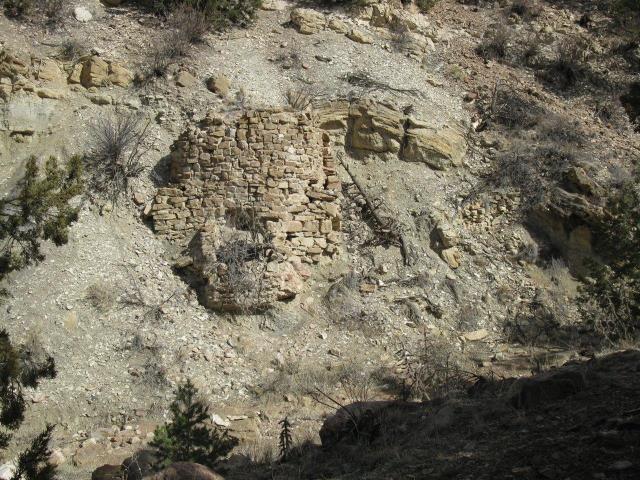
My wife and I discovered an ancient stone ruins site while prospecting for gold back in 2013.
The site consists of three structures that are constructed onto the natural steep slope of the side of a dry arroyo leading down to a river a few miles away. A query to U.S. Department of Interior returns no knowledge of any previous investigation or other documentation of this site.
My first impression was that it may have been a mining or homestead site, a kiln or storage area in the shelter of the arroyo. After looking it over closely, it was apparent that it was built long ago due to the 10 foot depth of erosion observed from the base of the structures to the present bottom of the channel. There isnt a historic wagon road or trail to the site. There is no near source of water. It appeared to me to resemble the cliff dwellings in SW Colorado more than anything else Ive seen.
The largest of the ruins is a round structure of crude unshaped natural stone blocks, essentially forming a tower with a solid flat top. The mortar material of the 'tower' and the smaller rectangular structures nearby appears to be a kind of course cement made up of pebbles and gravel found locally. The possible ceremonial aspect that gets my attention is the platform at the base that points towards a notch in the horizon at 245 degree (m), the near angle of the summer solstice sunset. There is a possibility that the tower covers an underground tunnel dug into the soft siltstone-shale that forms the bank of the arroyo. The structures might have been covered over after being built by simply pushing down the steep slope some of the fill and alluvial materials found uphill of the ruins.
There is still much to be learned at this site and I would appreciate any ideas that you might have. Presently, I am looking into the possibility that these stone ruins may have been constructed by one of the 7 caravans that traveled north with Montezumas Aztec Treasure. For sure, the Conquistadors were present in this area spanning many decades after Cortezs activity in present day Mexico.
|
Posted by: fenixsmom Jan 24 2015, 02:08 PM
That is so freaking cool!
Posted by: fenixsmom Jan 24 2015, 02:12 PM
Lol I was going to show off my lil archaeological dig site, but yours is SO much more interesting! 
Posted by: ColoradoProspector Jan 24 2015, 02:38 PM
Very cool find you two! It will be very exciting to see if it is a tunnel behind that. Sorry but I don't have any more info historically to offer on it. Looking forward to updates for sure, awesome find!

Posted by: fenixsmom Jan 24 2015, 02:49 PM
Is there any sort of mortar in-between the cobbles? It almost looks like the ruins of the late 19th or 20th centuries. However on a small screen it's hard to tell.
Edit: just noticed you answered the question I posed already. Sorry about that.
Posted by: ASTROBLEME Jan 24 2015, 03:21 PM
Here's a pic looking down channel. This gives you a better idea as to the depth of erosion and how the structures seem to be "heading underground".
|
Posted by: Crusty Jan 24 2015, 03:37 PM
What an amazing find! Goes to show how much cool stuff there is out there left to discover!
Posted by: ASTROBLEME Jan 24 2015, 03:38 PM
The source for the mortar is in the near vicinity. The builders dug under a cemented bed of gravels and took out suitable limestone for making the mortar. You can see the gray limestone form a seam almost looking like a vein in the "blurry" pic ...sorry about the blur but it was dark inside and I was on my belly trying to avoid snakes!"
|
|
Posted by: ASTROBLEME Jan 24 2015, 03:57 PM

Edit: just noticed you answered the question I posed already. Sorry about that.
The mortar resembles a very poor concrete. Interestingly, there are pieces of wood charcoal that has been preserved in some of the fillings. The calcium has really diffused out of the mortar and coats everything it touches. Keeping in mind that this is an arid environment, rain and snow over time has caused the calcium to seep out onto the stone below the filling in the pic below.
|
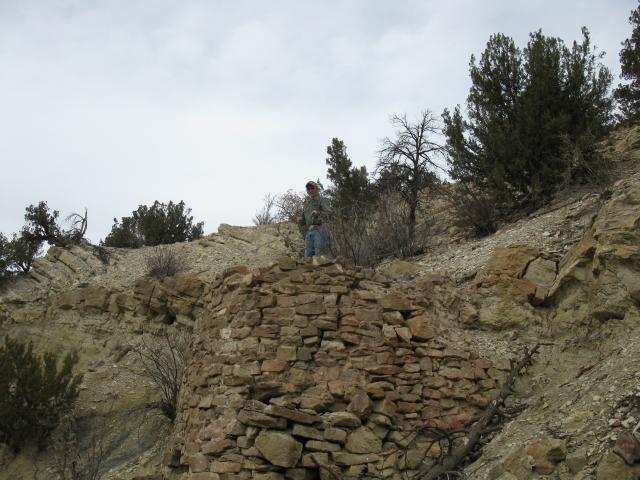
Posted by: ASTROBLEME Jan 24 2015, 04:08 PM
To give you an idea as to the size/scale of the structures, here is a pic of my archaeologist friend during a site visit. He is standing on the top of the "tower" structure collecting some survey data.
|
Posted by: Rockyrat Jan 24 2015, 04:32 PM
First off this is very cool. I originally came across the CP forums because I was researching lost treasures. I do have a couple of questions.
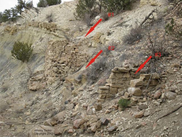
1) What do the numbers and arrows in the second picture represent?
2) In the first picture it almost looks like there's a small opening near the bottom of the wall behind the dead bush. It also looks like the opening is behind the small outcropping seen in the second picture. Is it an opening? To me it almost looks like a primitive grain silo.
3) I can see several old cans in the pictures. Did you inspect any of them for clues?
4) Do you have more pictures?
Posted by: ASTROBLEME Jan 24 2015, 05:38 PM
1) What do the numbers and arrows in the second picture represent?
2) In the first picture it almost looks like there's a small opening near the bottom of the wall behind the dead bush. It also looks like the opening is behind the small outcropping seen in the second picture. Is it an opening? To me it almost looks like a primitive grain silo.
3) I can see several old cans in the pictures. Did you inspect any of them for clues?
4) Do you have more pictures?
Hello Rockyrat and welcome to the CP Forums. Hopefully you will find lots of helpful information. Here's the answers you requested;
1) The arrows were added by me in an early photo I took of the site just to give each structure a number as research began and information was being sent out to those who were assisting me. The Tower is #1, #2 is behind a rock wall and not visible from that angle and #3 is the low-walled narrow structure furthest from the tower.
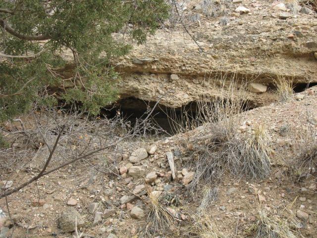
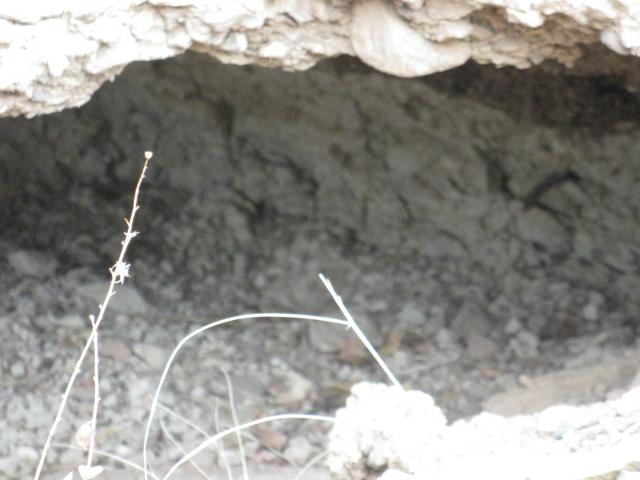
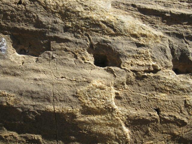
2) There is an opening right behind the "platform" at the base of the tower. It is sealed off except for an animal burrow. My archaeologist friend dismissed grain storage right away when he made a site visit.
3) The old cans are nothing more than trash that is the result of more modern peoples using the vicinity arroyos for their trash disposal. Some cans came downhill but most arrived from further upchannel during flood events.
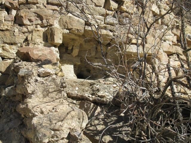
4) I've placed a photo below of the opening behind the platform on the base of the tower and what is curious, to me at least, is the orientation of some stones changes from horizontal to vertical. They look pretty unstable and could be a trap set to cave in on someone trying to dig into the tower...
|
Posted by: ASTROBLEME Jan 24 2015, 07:38 PM
Dear Treasure Seekers,
You may know something about "mounds" that I am not aware of since my focus is primarily geology and the mineral values that are in place due to natural forces. If you have expertise in mounds & mound builders, I would like your opinions on this Stone Ruins Site.
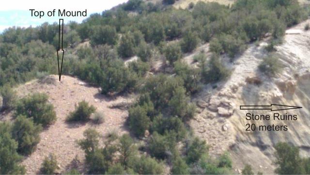
Last summer I realized that an interesting geological feature at the site looked much like an ancient mound. This mound appears to me to be the result of the builders disposing of material from an excavation. As I look at it, the mound is a lot like a conical pile of gravel deposited from the back of a large dredge. But keep in mind that this site is in an area that is very dry and arid and no gold dredging ever took place here.
At this point in the research effort, my opinion is that the mound in the photos below, is the result of a non-natural deposition. I am currently thinking that the conical pile covers another stone ruins structure. The faulting and folding of the limestone, siltstone and shale at this site allows for easy excavation, by hand or primitive tools, into an extensive layer of soft deposits along the bank of the arroyo. The builders of the stone ruins could have hidden the structures by covering them with easily accessible materials. I think there is a good possibility of an extensive tunnel system in this area due to the fact that the surface of the mound is rounded rocks while the surroundings are limestone,shale and ancient inland sea deposits!
Do you have any thoughts about the cone shaped mound top and the rocks placed upon it? What are your ideas as to how this pile of "rounded gravels" could form form a mound so close to the stone ruins?
If you would like to get involved with this effort...please let me know what your expertise is and how you could assist.
ASTROBLEME
MOUND TOP
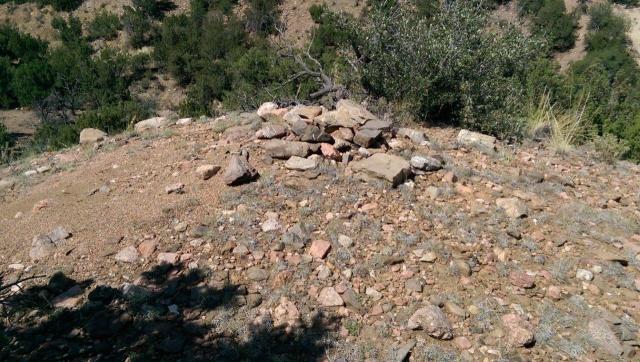
|
MOUND VIEW
|
Posted by: RhodoRose Jan 25 2015, 09:00 AM
'Morning!
My interest in archeology used to be (!) far greater than my interest in prospecting, and CP members are no dummies; but let me state the obvious, for the record: be very, very careful not to tamper with sites which are obviously man-made. Antiquities Act laws are as harsh and unforgiving as prospecting laws, and the federal gov't is really nasty about prosecuting anyone messing with what they deem an important site, before or after someone's touched it.
That said - Cool finds!
RhodoRose
Posted by: fenixsmom Jan 25 2015, 11:46 AM
If I'm not mistaken, the only civilizations that have been in CO are the native Americans, the Mexicans, maybe the Spaniards, and white settlers. I would look for tools and markings on the stone. Large chips on the cut edge would suggest stone, smoother cuts would suggest steel or iron. Keep an eye for bone piles and pottery. I always wanted to be an archeologist 
Posted by: fenixsmom Jan 25 2015, 11:48 AM
Of course, heed warning to Rhodo! If you find anything significant, be very careful and learn those lass!
Posted by: ASTROBLEME Jan 25 2015, 12:35 PM
My interest in archeology used to be (!) far greater than my interest in prospecting, and CP members are no dummies; but let me state the obvious, for the record: be very, very careful not to tamper with sites which are obviously man-made. Antiquities Act laws are as harsh and unforgiving as prospecting laws, and the federal gov't is really nasty about prosecuting anyone messing with what they deem an important site, before or after someone's touched it.
That said - Cool finds!
RhodoRose
RhodoRose,
Thanks for stating the obvious for forum visitors who might have intentions other than just learning about this discovery and sharing of ideas as to who built the structures and for what purpose were they created. My research efforts in this matter are non-destructive and non-disturbing. The site remains intact and unaltered. No laws, legal or moral are being broken by this effort.
My main concern about putting this information into this public forum is to keep the location safe from vandals while experts are making their observations. That is why the photos don't show horizons or other identifying views that could reveal the ruins location. Also, all digital Lat/Lon data is stripped from the photo files before they leave my desk. So I am confident that the location will remain secure for now.
If there are experts that come across this post and want to assist with the research, please get in touch with me.
ASTROBLEME
Posted by: fenixsmom Jan 25 2015, 02:56 PM
Sorry for trying to help. Maybe you should contact a museum insted of a public forum.
Posted by: swizz Jan 25 2015, 03:13 PM
What?

I beg to differ.... Johnny is a pro. I'm loving the thread, incredibly interesting and is of much historic value for nerds like me. Please keep up the pics!

Posted by: RhodoRose Jan 25 2015, 04:09 PM
Totally understand, Astro, Thank-you for clarifying what you're doing for the general public. Indeed, if this were in the protected member area, I probably wouldn't have bothered to say anything.
Regarding fenixmom's comment about contacting a museum, it's certainly a valid suggestion. I don't know what the laws are regarding man-made structures; but, for instance, if you find a vertebrae fossil, you are required to contact the state paleontologist regardless of whether or not you are considered an expert in the field.
Lastly, for members of the general public who come across this thread: there are many laws regarding prospecting, archeology, and paleontology, and if you peruse this forum you will see a LOT of warnings, cautions, and just plain words of wisdom, as well as a goodly amount of information regarding research and prep work prior to going out in the field.
Like I said before - Cool Finds, I'm envious!
Cheers! 
RhodoRose
Posted by: ASTROBLEME Jan 25 2015, 06:22 PM
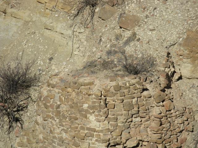
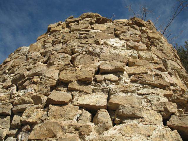
Here is a photo of the top of the "tower" structure. To me, the stones are set such that it is built into or right through the loose material on the slope rather than just following a course on the surface of the slope. The top is solid, with stones set in mortar, not just filled by loose debris from uphill. It doesn't take too much imagination to assume the structure could be covering a tunnel entrance.
|
Posted by: RhodoRose Jan 25 2015, 10:21 PM
I agree - it does look like the entrance to a tunnel. But my question would be, if someone were trying to hide a tunnel entrance (with valuable things inside), wouldn't a pile of rocks be a lot less obvious than a constructed wall? But perhaps the wall wasn't built to hide what was underneath, merely to protect it from the elements.
I'll look back through my Colorado history books and references for historical ideas. The only thing apparent to me from first glance is that the stones do not have the narrow "ledge stone" appearance seen in Chaco culture. A rough idea of what area of the state this is located would narrow the number of theories considerably, if you care to send me any clues in a PM. Nothing too specific, perhaps just a couple of county names.
Rhodo
Posted by: Coalbunny Jan 26 2015, 01:13 AM
Jessie, Aztec & Mayans were in Mexico & South America. The Spanish, French & Portuguese were before the Mexicans as the Mexicans are a mix of either of the three counties and the indians in Mexico.
Could be other indian cultures, though the selection of those that worked with such tools and structures is limited.
My vote is for the Si'teca.
Posted by: fenixsmom Jan 26 2015, 09:24 AM
Thanks Coalbunny! I always thought Colorado meant colorful state in Spanish. I was confused. Thank you very much for the correction!
Edit: fact checked myself. Colorado is a Spanish adjective that means “red.” The early Spanish explorers in the Rocky Mountain region named a river they found the Rio Colorado for the reddish silt that the water carried down from the mountains
No more posting pre-coffee for me! Lol.
Posted by: fenixsmom Jan 26 2015, 09:42 AM
I had a thought yesterday. (watch out!) Is there any ancient rivers nearby or a place for crops? Without either, life would be very hard to sustain unless the culture was just hunter/gatherers.
Posted by: Woody Jan 26 2015, 11:14 AM
Cool Thread! Possibilities abound. Wish I would have been watching this all along.
In my travels Ive come a crossed a few of these Semi-circular stone walls. Almost all of those were used in shoring up steep drainages that were along some ol forgotten trail or path. You seem to have already covered this possibility and I see by the pictures that the top is fairly round and not horizontal or built flat into the hill side. So Ill try to add a few different angles. Oddly enough, this is not the first time I have also seen one with an adjacent structure.
By chance have you tried to look at this site on google maps, or similar? My thoughts here are that with the dry arroyo and hills being so steep maybe all traces of the trail in the immediate area have been eroded away but with an expanded view you might be able to connect the dots so to speak. On a large scale you might be able to etch out where this site was an important midway point to a further destination. Kind of like a stagecoach stop, but obviously not.
As for the rocks by the Drainage Hole I suggest they appear to be a sort of half-circle cap stone. A few are missing and appear to have dropped down over time. This however would suggest being more of a decorative piece rather than something needed for functionality. I know all my thoughts here are strictly flights of fancy and embellished, but here goes another one. That flat stone at the end of the drainage hole looks to me to be usable for Catch Basin. And if that is the case the mystery of the Dome Structure could be solved.
A lot of natural seeps and springs today have a man-made covering or have been altered in some way to make their use more convenient to us. Most of them just have a pipe pounded into the wall and dump into a trough of some sort but a few have an earth covering that helps draw out the water. A simple explanation; Imagine if this was a support wall, the hole in the center would be necessary for drainage. Thoughts of control would need to be implemented into the design for Runoff. Trapped water behind a structure like that might quickly bring it down from just the mechanical weathering of freezing and thawing alone. One of the by-products of this type of design was the discovery that the drainage hole continued to weep long after the immediate runoff or storm had passed. That silt layer at the base of the large sandstone outcropping could easily have produced a small natural drainage years ago. Maybe someone built this structure in an attempt to channel a wide seep into a usable one.
The structure to the far right of the three is an Inny, not an Outty. Meaning who ever built this first removed a large volume of earth and then built the foundation into the hill. Most Native Americans were not to keen on building Innies. They normally improved upon already existing natural structures like building a wall around a hollow depression, resulting in an outty.
Here is a possible way to help date the site and plays into your well-house of expertise. I suggest you test the chemical composition of the mortar. Native Americans made this mortar differently than did European settlers. Europeans favored cement more so than mortar. Everyone knows that one of the ingredients of early cement was Ashes. One of the pics clearly show what looks to be ashes in the mix. Other ingredients used might help to establish a date, just like an index fossil.
Sorry so long. Hope you someday solve the mystery, Woody.
Posted by: Crusty Jan 26 2015, 12:01 PM
WOODY! Good to hear from you; hope all is well with you!
Interesting addition to the discussion. Look forward to hearing more as y'all look in to it further!
Posted by: ASTROBLEME Jan 26 2015, 07:42 PM
Another photo of the tower...this shows the rounded shape very well.
|
Posted by: Coalbunny Jan 26 2015, 10:43 PM
Edit: fact checked myself. Colorado is a Spanish adjective that means red. The early Spanish explorers in the Rocky Mountain region named a river they found the Rio Colorado for the reddish silt that the water carried down from the mountains
No more posting pre-coffee for me! Lol.
It does, more like "colored red", IIRC. But then mi habla poquito espainol.
Taaaaaco....
Burrrrreto....
JOSE CUERVO! Ei Yi Yi!

I am with woody though. I think that's an Aztec Outty. 'Cause what you don't find's liable to be the
 !
!
Posted by: ASTROBLEME Feb 9 2015, 11:47 PM
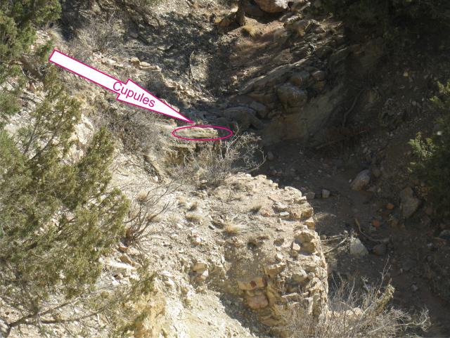
Everyone,
Ive observed a line of man-made holes in the fault slickenside near the Tower at the stone ruins site. These unique features appear to be Cupules, frequently referred to as the earliest form of rock art. Numerous examples have been found on every continent except Antarctica. Cupules were produced during all three eras of the Stone Age - Paleolithic, Mesolithic and Neolithic - as well as in historical times. The holes appear to be very old, having visible surface erosion and lichen growing in the pit.
|
|
Posted by: MikeS Feb 10 2015, 12:33 AM
The tower and the holes surely look man-made to me Astrobleme. Very Cool!
Posted by: ASTROBLEME Feb 10 2015, 09:44 PM
Everyone who is following this,
I want to thank you for your interest. This site has been kept from the public records until I became aware of a proposed project I saw in the news as the Ecology Park Area Trail Development (DOI-BLM-CO-F02-2014-0031 EA). My family and others continue pushing the Department of Interior to protect this site.
A couple of days ago, a BLM archeologist told me that the ruins were either an unused kiln to bake bricks from a clay source 2 miles away or the ruins was used to burn local trash. 
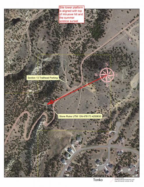
It is obvious now, the best way to protect these ruins is to let the public know the location so that they can take actions to protect the site. Here is the Treasure Map... 
|
Posted by: fenixsmom Feb 10 2015, 10:28 PM
Ahh. Now I see why you posted it's location. That isba good idea indeed.
Posted by: ASTROBLEME Feb 12 2015, 06:23 PM
There will be a tour of the stone ruins site that is located within the boundaries of the BLM and Recreation District Trails Project at Canon City, Colorado. A group will be leaving from the south end of the Ecology Park (on Temple Canyon road) parking lot at 1:00 p.m. this Saturday, February 14th. All interested parties are welcome to come along. The ruins are close to a road and very little hiking is involved. The weather forecast is excellent for this short outing.
Please consider taking some time to visit this site as it is possibly the oldest standing masonry structure in Fremont County.
Posted by: RhodoRose Feb 12 2015, 11:16 PM
Thanks for the info, Astro - it just so happens I'm not working shift this weekend, I'll plan on being there!
p.s. fyi, here's a map showing where Ecology Park is.  ecology_park.pdf ( 2.37MB )
: 746
ecology_park.pdf ( 2.37MB )
: 746
Posted by: ASTROBLEME Feb 13 2015, 09:10 AM
p.s. fyi, here's a map showing where Ecology Park is.
ecology_park.pdf ( 2.37MB )
: 746Thanks for putting up the map RhodoRose. If you're running late, drive on up County Road 3 (Temple Canyon Road) to the Section 13 Trailhead Parking Lot. Just look for my black Ford Raptor and I won't be too far away... down in the nearby gulch as shown on the Treasure Map.
Look forward to meeting you!
Posted by: Mrs.CP Feb 15 2015, 02:49 PM
You are top notch Johnny!!  What a fantastic opportunity to get an up close view of such a fantastic location. Amazing to be able to put the pieces together of history like that Johnny.
<---Watches Johnny feed the coal into his train. 

Posted by: ASTROBLEME Feb 20 2015, 07:55 PM
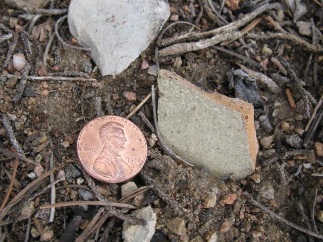
On the tour, I found broken pottery that appeared to be eroding out from a mound. Here is a photo of one of the shards in place...undisturbed...the penny is mine that I used for size comparison. The shard remains where it was discovered, the penny went back into my pocket. A penny saved is ...a penny 
|
Posted by: ColoradoProspector Feb 21 2015, 05:36 PM
It is a penny! 
Interesting to find more pieces of the puzzle on the tour, cool. Sounded like a fun day with the tour checking out the site, wished I could have made it. Look forward to hearing more about what's learned in the future as it's studied too! Thanks for the updates Astrobleme, good work with this project!
Posted by: ASTROBLEME Feb 25 2019, 07:57 PM
Hi Everyone,
It's been a few years since I've posted anything new on this thread. I hope you find this update interesting.
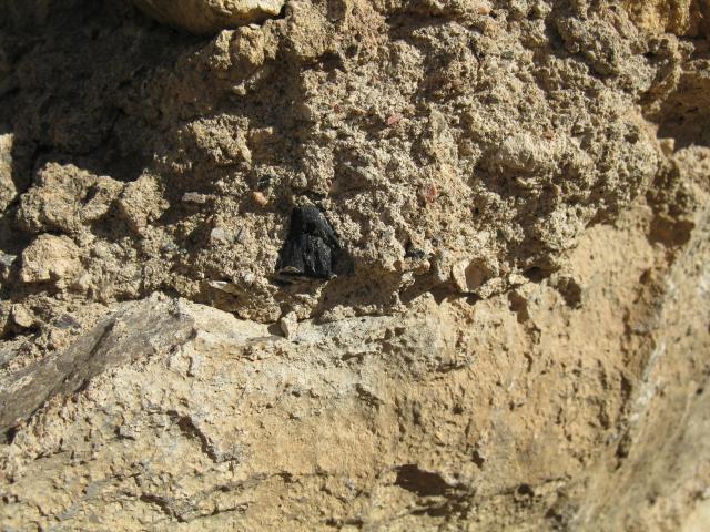
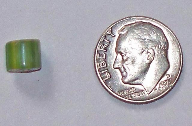
My archaeologist friend found a bead that eroded from the steep creek bank at the Tower site. He sent me these photos;
|
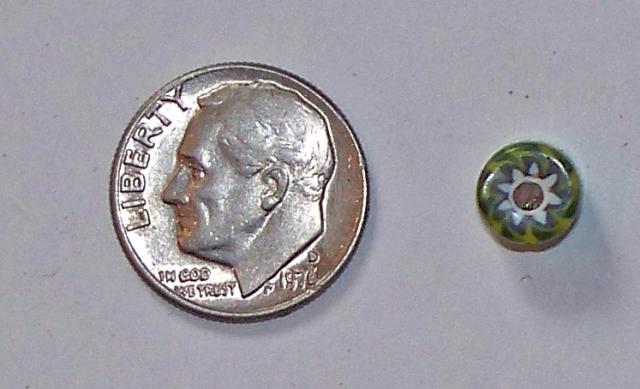
|
I'm thinking that it is possible that this "green" trade bead is associated with Chief Cuerno Verde (translated from Spanish to Greenhorn). The Spanish named him, Cuerno Verde because of his remarkable bison-horned headdress. In late October of 1768, 500 Comanches attacked Ojo Caliente before dawn attempting to wipe out all the Spaniards. During the attack the Spanish killed the Comanches charismatic leader, Cuerno Verde in the town square. The chiefs son, Tabivo Naritgant took his father's name and dedicated himself to killing Spaniards in revenge. His given name was Tabivo Naritgant, or "Dangerous Man." He received his distinctive leather headdress with green-tinted buffalo horns from his father. Comanche beliefs bound Cuerno Verdes family to avenge his death.
Juan Bautista de Anza chased after him. Cuerno Verdes distinctive headdress was claimed by Anza. He sent it to Teodoro de Croix, the first commandant general of the Northern section of New Spain. According to legend, it was forwarded to his superiors who eventually sent it to the Vatican, where it still may be buried in the Library.
No one has found artifacts to prove the actual location of the battle between Anza and Cuerno Verde. Wilfred O. Martinez (a descendant of Bernardo Miera y Pacheco, the mapmaker for Anzas campaign) believes the site is 18 miles south of Pueblo near the Burnt Mill Road Bridge over the St. Charles River (Rio San Carlos). He thinks others had been misled by a bad translation of zanja. They thought it meant bog or swamp, when it fact its an arroyo. The monument in Greenhorn Park was moved there from another location west and closer to Greenhorn Creek. It is unlikely that it marks the exact location of the battle.
The history noted above was part of the documentation from this source;
http://www.greenhornvalleyview.com/index.asp?linkID=63&itemID=9318
Sincerely,
ASTROBLEME
Powered by Invision Power Board (http://www.invisionboard.com)
© Invision Power Services (http://www.invisionpower.com)