GOLD MINING CLAIM near Fairplay Colorado FOR SALE, High Grade Ore Stockpile from London Mine and Placer Grounds |


 Colorado Prospector - Gem and mineral prospecting and mining forums > Miners Crafts, Goods & Classified ads > Wanted > SOLD or Found!
GOLD MINING CLAIM near Fairplay Colorado FOR SALE, High Grade Ore Stockpile from London Mine and Placer Grounds |
 Jan 5 2018, 06:58 PM Jan 5 2018, 06:58 PM
Post
#1
|
|||||
 Rock Bar!  Group: Members Posts: 613 Joined: 16-October 08 From: Central Colorado Member No.: 6,813 |
NOTICE:
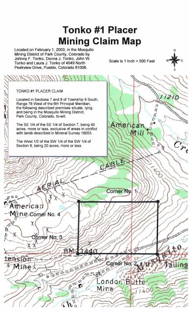
Due to the high grade nature of the gold ore stockpiled on this claim,the area is patrolled and monitored. This Federal Mining Claim is located, recorded, and maintained in accordance with 43 C.F.R. Part 3800 and 30 U.S.C. 22 et seq.; 43 U.S.C. 1744 and all appropriate state laws. All persons are warned that disturbance of the monuments, surface, or improvements on this claim or removal of minerals of any type without permission of the claimant(s), will result in their prosecution under the appropriate state and federal statutes. HISTORY: The London Mine Group was developed on pollymetallic quartz veins associated with the Great London Fault. According to documentation by Singewald and Butler (1941) the ore mined between 1895 and 1910 averaged 2.895 opt gold, 2.858 opt silver, 4.13 % lead, 2.66 % zinc, 4.85 % iron, 6.11 % sulfur, and 76.8 % silicon. The most recent reports published by the Colorado Geological Survey state that remaining mine and stockpile resources range from 0.10 to 0.41 opt gold having a weighted average of 0.19 opt gold. Most of the Tonko #1 CMC289770 mining claim was formerly known as the Jewett #1 CMC94664 and the Jewett #2 CMC94665 mining claims that were held by London Mine Venture from 1935 through 1991. The stockpile on Tonko #1 was estimated by Behre Dolbear & Company, Inc. in a report dated March of 1985 to contain 172,000 tons of gold ore! MINING CLAIM MAP:
GOOGLE EARTH VIEW OF CLAIM:
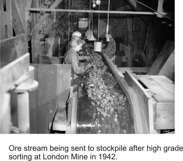
HIGH GRADE SORTING OF ORE: This photo shows the limited number of employees hand sorting out the exceptionally high grade ore being transported from the mine. Only the highest grades of visible gold ore were hand picked off of the conveyor belt and shipped out for processing. The mine had taken out all processing equipment after World War I due to high taxation. The gold ore stockpile was created by using a small mining train that traveled about 1/4 mile uphill from the sorting facility and dumped along the mountainside for future processing. The round-trip for stockpiling was about 1/2 mile and the volume of ore that was stored now looms over the local area. Since the hand sorting crew wore thick gloves and the speed of the conveyor belt moved exceptional specimens right past the sorting crew, substantial volumes of exceptionally high grade ore was subsequently transported out to the stockpile.
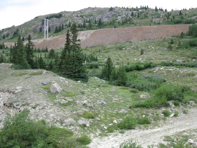
STOCKPILE PHOTO:
CONTACT: President of Tonko Mining Company, Inc. -------------------- Annual Dues Paying Member Since 2008
Tonko Mining Company "Some day this crater is going to be a greatly talked about place, and if the above credit is due, as is certainly the case, I would like to have it generally known for the sake of the children." Daniel Moreau Barringer 2/1/1912 in a letter about the Barringer Meteorite Crater, Arizona USA |
||||
 |
 
|
||||
 |
|
Aug 17 2018, 03:22 PM
Post
#2
|
|||
|
Rock Bar! Group: Members Posts: 613 Joined: 16-October 08 From: Central Colorado Member No.: 6,813 |
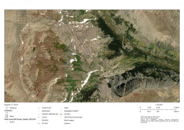
I went up to my claim on Wednesday to get some drone photos. There was a man and woman walking near the blockade and a couple of cars were parked outside the gate along the road. Nobody stopped me but I became very concerned about the dangerous conditions that have been created on that blind corner. There were children's bikes with training wheels, unlicensed vehicles and heavy equipment alongside or upon the travel surface of the road at that green gate. It appears that someone is now living "on" the road. Anyone traveling up there needs to use extra caution!
I filed a complaint via Email yesterday morning with the Park County Right-Of-Way Division. Here's their link; Park County Road Right-Of-Way Division The Park County GIS data clearly shows the county and USFS ownersip of 696 all the way up to the top of Mosquito Pass. This would be a good visual aid if you're meeting with authorities on this matter. The light green dashed line is USFS road that meets up with Park County 12 at the summit of Mousquito Pass. This road is also a Designated Snowmobile Route as depicted on the current Pike National Forest map.
reinhold, I appreciate your efforts to follow-up on this. This problem needs to be resolved before someone crashes into the gate or worse! ASTROBLEME -------------------- Annual Dues Paying Member Since 2008
Tonko Mining Company "Some day this crater is going to be a greatly talked about place, and if the above credit is due, as is certainly the case, I would like to have it generally known for the sake of the children." Daniel Moreau Barringer 2/1/1912 in a letter about the Barringer Meteorite Crater, Arizona USA |
||
|
|
|
||
 ASTROBLEME GOLD MINING CLAIM near Fairplay Colorado FOR SALE Jan 5 2018, 06:58 PM
 GoldenSilva How much is this Claim? Also, do you know of more ... Jan 6 2018, 02:15 AM ASTROBLEME The most recent gold mining activity near Fairplay... Jan 6 2018, 05:51 PM Crusty Wow, another amazing Tonko claim. Good luck with y... Jan 6 2018, 06:51 PM ASTROBLEME In 2001, the Colorado Geological Survey published ... Jan 10 2018, 11:52 AM Crusty Was great to finally meet the infamous Johnny Tonk... Jan 10 2018, 03:44 PM ASTROBLEME For further consideration in this matter, the ... Jan 10 2018, 06:03 PM dino27 please see table of bulk sampling results from Beh... Jan 11 2018, 10:46 AM
 ASTROBLEME QUOTE (dino27 @ Jan 11 2018, 09:46 AM) pl... Jan 11 2018, 11:32 AM Denise Dean, do not enter this community trying to cause ... Jan 11 2018, 12:01 PM Denise My pleasure Dean! Jan 11 2018, 12:47 PM ASTROBLEME I had some requests for pics so I'm sharing th... Jan 11 2018, 09:11 PM Gene Kooper QUOTE (ASTROBLEME @ Jan 11 2018, 08:11 PM... Jan 12 2018, 04:34 AM Gene Kooper GeoMatt,
I too am disappointed at the above respo... Jan 12 2018, 04:45 AM Denise Gene, I stand by what I said. It was obvious that ... Jan 12 2018, 09:19 AM ASTROBLEME Please understand that the report I'm quoting ... Jan 12 2018, 10:10 AM ASTROBLEME Here's the math...
The newest data presented ... Jan 14 2018, 11:03 AM Gene Kooper I didn't realize that two "PG"s coul... Jan 14 2018, 04:26 PM ASTROBLEME Everyone,
I would encourage you to do your own re... Jan 14 2018, 05:09 PM GeoMatt QUOTE (ASTROBLEME @ Jan 14 2018, 05:09 PM... Jan 17 2018, 09:55 AM EMac Johnny - best of luck in your endeavors sir.
Deni... Jan 17 2018, 06:56 PM ASTROBLEME Everyone expressing an opinion on this FOR SALE of... Jan 18 2018, 08:00 PM EMac Have you tried posting this in ICMJ? I just looked... Jan 19 2018, 09:50 AM Denise Johnny was told by Dan that he could post his clai... Jan 19 2018, 10:00 AM EMac No doubt; I'm just thinking that when I sold m... Jan 19 2018, 05:26 PM ASTROBLEME In addition to the Colorado State report cited abo... Jan 21 2018, 12:49 PM ASTROBLEME There was an incident in early 2013 that revealed ... Jan 31 2018, 09:53 AM ASTROBLEME Two historical photographs showing the extensive ... Feb 2 2018, 12:48 PM ASTROBLEME DEAN MISANTONI OVERSTAKED THE TONKO STOCKPILE SIX ... Feb 4 2018, 12:03 PM ASTROBLEME While most of the ore has gold that isn't visi... Feb 18 2018, 12:44 PM Crusty beautiful specimins!! Feb 19 2018, 11:00 AM johnnybravo300 So he never wanted anything to do with the stockpi... Feb 19 2018, 04:11 PM ASTROBLEME SOME MORE HISTORY
My Grandfather mined in the coa... Feb 19 2018, 07:18 PM reinhold QUOTE (ASTROBLEME @ Feb 19 2018, 08:18 PM... Aug 12 2018, 09:27 AM ASTROBLEME QUOTE (reinhold @ Aug 12 2018, 10:27 AM) ... Aug 12 2018, 11:49 AM reinhold QUOTE (ASTROBLEME @ Aug 12 2018, 12:49 PM... Aug 16 2018, 06:13 PM reinhold Called the FS line today, and they said that they ... Aug 17 2018, 02:19 PM johnnybravo300 Very interesting history. Grandfathers sure can ha... Feb 20 2018, 08:45 PM ASTROBLEME The richer mines in Colorado's high country ha... Feb 23 2018, 07:48 PM ASTROBLEME PLEASE TAKE NOTICE:
The asking price for this 60 ... Mar 12 2018, 11:12 AM ASTROBLEME This past Monday, BLM issued a decision on the Min... Apr 6 2018, 10:12 AM Crusty good news! Hope you find a buyer soon! Apr 6 2018, 11:53 AM ASTROBLEME I want to extend our family's offer to the suc... Apr 6 2018, 06:36 PM Clay Diggins Is the gate locked Johnny?
All of 9S 78W Sectio... Aug 18 2018, 12:30 PM ASTROBLEME QUOTE (Clay Diggins @ Aug 18 2018, 01:30 ... Aug 18 2018, 06:52 PM Clay Diggins QUOTE (ASTROBLEME @ Aug 18 2018, 06:52 PM... Aug 18 2018, 09:08 PM ASTROBLEME QUOTE (Clay Diggins @ Aug 18 2018, 10:08 ... Aug 19 2018, 02:18 PM ASTROBLEME Clay Diggins,
Yesterday you wrote this in support... Aug 19 2018, 06:05 PM Clay Diggins QUOTE (ASTROBLEME @ Aug 19 2018, 06:05 PM... Aug 20 2018, 02:03 AM ASTROBLEME QUOTE (Clay Diggins @ Aug 20 2018, 03:03 ... Aug 20 2018, 06:19 AM Clay Diggins QUOTE (ASTROBLEME @ Aug 20 2018, 06:19 AM... Aug 20 2018, 10:23 PM ASTROBLEME Everyone,
Here's a map that will help with un... Aug 21 2018, 09:12 AM ASTROBLEME Everyone,
The road known as CR 696 is a county ro... Aug 22 2018, 05:21 PM reinhold QUOTE (ASTROBLEME @ Aug 22 2018, 06:21 PM... Aug 23 2018, 09:36 AM Denise Great information Clay Diggins and ASTROBLEME, tha... Aug 23 2018, 09:28 AM ASTROBLEME We have revised our asking price for the gold stoc... Oct 11 2018, 05:28 PM ASTROBLEME Most of the very high grade specimens have already... Oct 16 2018, 06:42 PM ASTROBLEME ASKING PRICE UPDATE
We've had to rescinded ou... Jan 3 2019, 07:34 PM ASTROBLEME In 1938, there was a nugget mined from the Bulger ... Jan 4 2019, 05:19 PM ASTROBLEME Everyone,
I hope you'll find the attached rep... Feb 21 2019, 07:42 PM ASTROBLEME Thanks for the interest in this gold mining claim.... Apr 22 2020, 07:01 PM johnnybravo300 I wouldnt sell it either!
It will be worth alo... Jun 7 2020, 07:42 AM
ASTROBLEME QUOTE (dino27 @ Jan 11 2018, 09:46 AM) pl... Jan 11 2018, 11:32 AM Denise Dean, do not enter this community trying to cause ... Jan 11 2018, 12:01 PM Denise My pleasure Dean! Jan 11 2018, 12:47 PM ASTROBLEME I had some requests for pics so I'm sharing th... Jan 11 2018, 09:11 PM Gene Kooper QUOTE (ASTROBLEME @ Jan 11 2018, 08:11 PM... Jan 12 2018, 04:34 AM Gene Kooper GeoMatt,
I too am disappointed at the above respo... Jan 12 2018, 04:45 AM Denise Gene, I stand by what I said. It was obvious that ... Jan 12 2018, 09:19 AM ASTROBLEME Please understand that the report I'm quoting ... Jan 12 2018, 10:10 AM ASTROBLEME Here's the math...
The newest data presented ... Jan 14 2018, 11:03 AM Gene Kooper I didn't realize that two "PG"s coul... Jan 14 2018, 04:26 PM ASTROBLEME Everyone,
I would encourage you to do your own re... Jan 14 2018, 05:09 PM GeoMatt QUOTE (ASTROBLEME @ Jan 14 2018, 05:09 PM... Jan 17 2018, 09:55 AM EMac Johnny - best of luck in your endeavors sir.
Deni... Jan 17 2018, 06:56 PM ASTROBLEME Everyone expressing an opinion on this FOR SALE of... Jan 18 2018, 08:00 PM EMac Have you tried posting this in ICMJ? I just looked... Jan 19 2018, 09:50 AM Denise Johnny was told by Dan that he could post his clai... Jan 19 2018, 10:00 AM EMac No doubt; I'm just thinking that when I sold m... Jan 19 2018, 05:26 PM ASTROBLEME In addition to the Colorado State report cited abo... Jan 21 2018, 12:49 PM ASTROBLEME There was an incident in early 2013 that revealed ... Jan 31 2018, 09:53 AM ASTROBLEME Two historical photographs showing the extensive ... Feb 2 2018, 12:48 PM ASTROBLEME DEAN MISANTONI OVERSTAKED THE TONKO STOCKPILE SIX ... Feb 4 2018, 12:03 PM ASTROBLEME While most of the ore has gold that isn't visi... Feb 18 2018, 12:44 PM Crusty beautiful specimins!! Feb 19 2018, 11:00 AM johnnybravo300 So he never wanted anything to do with the stockpi... Feb 19 2018, 04:11 PM ASTROBLEME SOME MORE HISTORY
My Grandfather mined in the coa... Feb 19 2018, 07:18 PM reinhold QUOTE (ASTROBLEME @ Feb 19 2018, 08:18 PM... Aug 12 2018, 09:27 AM ASTROBLEME QUOTE (reinhold @ Aug 12 2018, 10:27 AM) ... Aug 12 2018, 11:49 AM reinhold QUOTE (ASTROBLEME @ Aug 12 2018, 12:49 PM... Aug 16 2018, 06:13 PM reinhold Called the FS line today, and they said that they ... Aug 17 2018, 02:19 PM johnnybravo300 Very interesting history. Grandfathers sure can ha... Feb 20 2018, 08:45 PM ASTROBLEME The richer mines in Colorado's high country ha... Feb 23 2018, 07:48 PM ASTROBLEME PLEASE TAKE NOTICE:
The asking price for this 60 ... Mar 12 2018, 11:12 AM ASTROBLEME This past Monday, BLM issued a decision on the Min... Apr 6 2018, 10:12 AM Crusty good news! Hope you find a buyer soon! Apr 6 2018, 11:53 AM ASTROBLEME I want to extend our family's offer to the suc... Apr 6 2018, 06:36 PM Clay Diggins Is the gate locked Johnny?
All of 9S 78W Sectio... Aug 18 2018, 12:30 PM ASTROBLEME QUOTE (Clay Diggins @ Aug 18 2018, 01:30 ... Aug 18 2018, 06:52 PM Clay Diggins QUOTE (ASTROBLEME @ Aug 18 2018, 06:52 PM... Aug 18 2018, 09:08 PM ASTROBLEME QUOTE (Clay Diggins @ Aug 18 2018, 10:08 ... Aug 19 2018, 02:18 PM ASTROBLEME Clay Diggins,
Yesterday you wrote this in support... Aug 19 2018, 06:05 PM Clay Diggins QUOTE (ASTROBLEME @ Aug 19 2018, 06:05 PM... Aug 20 2018, 02:03 AM ASTROBLEME QUOTE (Clay Diggins @ Aug 20 2018, 03:03 ... Aug 20 2018, 06:19 AM Clay Diggins QUOTE (ASTROBLEME @ Aug 20 2018, 06:19 AM... Aug 20 2018, 10:23 PM ASTROBLEME Everyone,
Here's a map that will help with un... Aug 21 2018, 09:12 AM ASTROBLEME Everyone,
The road known as CR 696 is a county ro... Aug 22 2018, 05:21 PM reinhold QUOTE (ASTROBLEME @ Aug 22 2018, 06:21 PM... Aug 23 2018, 09:36 AM Denise Great information Clay Diggins and ASTROBLEME, tha... Aug 23 2018, 09:28 AM ASTROBLEME We have revised our asking price for the gold stoc... Oct 11 2018, 05:28 PM ASTROBLEME Most of the very high grade specimens have already... Oct 16 2018, 06:42 PM ASTROBLEME ASKING PRICE UPDATE
We've had to rescinded ou... Jan 3 2019, 07:34 PM ASTROBLEME In 1938, there was a nugget mined from the Bulger ... Jan 4 2019, 05:19 PM ASTROBLEME Everyone,
I hope you'll find the attached rep... Feb 21 2019, 07:42 PM ASTROBLEME Thanks for the interest in this gold mining claim.... Apr 22 2020, 07:01 PM johnnybravo300 I wouldnt sell it either!
It will be worth alo... Jun 7 2020, 07:42 AM |
| Lo-Fi Version | Time is now: 20th September 2024 - 10:59 PM |