Westcliffe and Silver Cliff Meteorite Craters, Further Evidence of Extinction Level Event |


 Colorado Prospector - Gem and mineral prospecting and mining forums > Exploring Our Universe > Space and Astronomy
Westcliffe and Silver Cliff Meteorite Craters, Further Evidence of Extinction Level Event |
 Mar 26 2016, 04:54 PM Mar 26 2016, 04:54 PM
Post
#1
|
||||
 Rock Bar!  Group: Members Posts: 613 Joined: 16-October 08 From: Central Colorado Member No.: 6,813 |
Greetings Everyone,
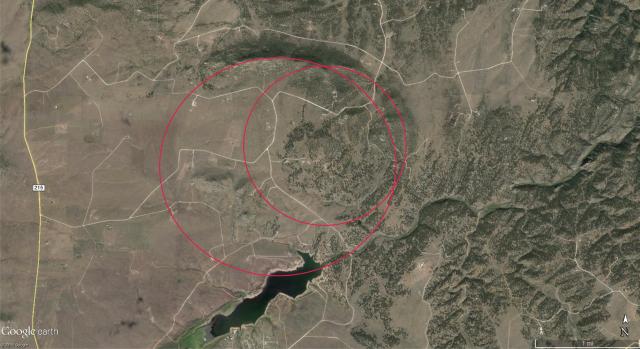
I am announcing this discovery as a long time contributor to the Colorado Prospector Forum and want to make sure that other members have access to this information. After initiating a research effort in 2005, I have been able to collect substantial evidence to support a double meteorite impact located in Custer County, Colorado. The Westcliffe Crater is the larger structure while the Silver Cliff Crater is smaller and both are named for the towns nearby. All my work has been done independently and at my own cost. This previously unrecognized double crater structure is paired with my discovery of the Gunnison Crater. All 3 impacts occurred 360 to 375 million years ago. These impact craters are further evidence supporting the Tonko Lineament that recognizes the serial impacts across the United States aligning on the 38th Parallel. The crater chain and associated fish fossil records I have researched indicate a Devonian mass extinction event where 70% of life on our planet was eliminated. Along with hyper-velocity geologic evidence in the target zone, I have also recovered two meteorite types that are in the early process of classification. Peak Ring Image of Westcliffe and Silver Cliff Craters
Westcliffe Meteorite (photo with light sourced to highlight metal inclusions but chondrules are still visible)
Silver Cliff Meteorite
Sincerely, Johnny Tonko -------------------- Annual Dues Paying Member Since 2008
Tonko Mining Company "Some day this crater is going to be a greatly talked about place, and if the above credit is due, as is certainly the case, I would like to have it generally known for the sake of the children." Daniel Moreau Barringer 2/1/1912 in a letter about the Barringer Meteorite Crater, Arizona USA |
|||
 |
 
|
|||
 |
|
Mar 16 2017, 12:42 AM
Post
#2
|
|
|
Shovel Buster! Group: Members Posts: 100 Joined: 24-May 15 Member No.: 120,476 |
I am not sure that this will be received well, but geologic terms do have specific meanings. The term lineament refers to linear features (usually on aerial photos and satellite images) that are thought to represent linear geologic structures (e.g. faults). Here is a standard definition of lineament from the "Glossary of Geology", Robert L. Bates and Julia A. Jackson, editors, American Geological Institute, 2nd edition, 1980.
QUOTE A linear topographic feature of regional extent that is believed to reflect crustal structure (Hobbs, et al., 1976, p. 267). Examples are fault lines, aligned volcanos, and straight stream courses [A short trip into the weeds] For geologists, the key is whether the linear feature/lineament is a surficial expression of a geologic structure. Photo-geologic interpretation usually includes the mapping of any straight features. There are two camps among geologists when it comes to distinguishing linear features and lineaments. The first camp hold the opinion that every mapped linear feature is a lineament (i.e. each linear feature demarcates a geologic structure). The second camp holds the view that a lineament is defined by a group of linear features. In other words, not every linear feature is a lineament. I belong to the second group. Many years ago when I took a remote sensing class, I was introduced to mapping linear features on Landsat imagery. In the late 1970s, Dr. Don Sawatsky, a geophysicist at the USGS developed a method to statistically evaluate linear features. The algorithm was called LINANL and consisted of 26 Fortran programs that ran on a Perkin-Elmer minicomputer. The software computed significant trends and contoured the density of linear features as aids in interpreting lineaments. I adapted the software to run on a PC and used it in my thesis research. Over the years I have used it numerous times to analyze photo-geologic mapping of oil and gas fields and vein-type mineral deposits. To show its utility and application I attached one USGS Open-File Report that employed LINANL to interpret potential mineral deposits in the Ruby Mountains. The link below is to a longer paper that used Landsat imagery to interpret crustal structures in the Cascade Range. [attachment=10551:Lineamen..._Montana.pdf] Analysis of Linear Features Mapped from Landsat Images of the Cascade Range, Washington, Oregon and California [/A short trip into the weeds] Thanks for bearing with me....now back to Mr. Tonko's term "Tonko Lineament". His hypothesis is that several possible impact craters line up along a parallel of latitude. Just because one connects several dots together does not make it a lineament. Using that term implies that there is a regional tectonic structure running due east-west. That is certainly not the case with these possible impact craters because there are no structural geologic "links" between the dots as is the case for a series of aligned volcanoes. From my perspective, it is intriguing that several possible impact craters are aligned along an east-west geodesic. However, the mere lining up of several points in an east-west trend does not prove they were created by a disaggregated comet. The key (to me) is whether the age of the sedimentary rocks at each possible impact site falls within a very short geologic time period (i.e. 370 million years ago). Correlating conodont species from the various sites may prove useful in establishing that narrow time window. I had asked Mr. Tonko in an earlier post in this thread if he would provide the full reference to a 2000 Warme paper on the Alamo Impact Breccia that he references on his web site. I was fortunate to take my graduate stratigraphy course from Dr. Warme in 1986. At that time his main research interest was in the Atlas Mountains of Morocco. Dr. Warme has collaborated with several researchers over the years on the Alamo Impact Breccia, and I would be interested in reading the paper that Mr. Tonko references on his website. |
|
|
|
 ASTROBLEME Westcliffe and Silver Cliff Meteorite Craters Mar 26 2016, 04:54 PM
 johnnybravo300 It looks like the Gunnison crater is in the Hartma... Mar 26 2016, 10:01 PM
 ASTROBLEME QUOTE (johnnybravo300 @ Mar 26 2016, 11:0... Mar 26 2016, 10:44 PM James and Cyndi Quite extraordinary!!! Thanks for shar... Mar 27 2016, 08:02 AM johnnybravo300 Wow what an awesome read. Makes perfect sense. The... Mar 27 2016, 07:24 PM Crusty awesome work; thanks for sharing Mar 27 2016, 11:48 PM ASTROBLEME Here's a close-up view of the chondrules in th... Mar 31 2016, 02:25 PM Gene Kooper For Astrobleme,
On your Crater Research web page ... Aug 14 2016, 03:20 PM Caveman HOLY CRAP!!!! I just looked at th... Jan 8 2017, 11:37 AM ASTROBLEME Hello Caveman,
Here's a photo of a field spec... Feb 2 2017, 12:37 PM Caveman QUOTE (ASTROBLEME @ Feb 2 2017, 11:37 AM)... Feb 3 2017, 08:50 AM ASTROBLEME Hello Caveman,
I'm sure you'll want to go... Feb 9 2017, 07:23 PM Caveman There is quite a bit that looks like that on the p... Feb 13 2017, 03:06 PM ASTROBLEME Exciting News...
Having received results from lab... Mar 4 2017, 05:59 PM johnnybravo300 Those two look identical to the eye.
So it is a ro... Mar 4 2017, 10:21 PM ASTROBLEME Understanding the natural forces involved in hyper... Mar 12 2017, 07:18 PM billwolf Hi guys, I am new to this site and just looking th... Mar 14 2017, 12:56 PM johnnybravo300 Welcome billwolf. Fascinating to say the least. An... Mar 14 2017, 01:40 PM ASTROBLEME I'm pleased to see all the interest in my effo... Mar 15 2017, 07:10 PM ASTROBLEME The largest geologic structures found across the s... Mar 16 2017, 01:54 AM Gene Kooper You are of course free to misuse the term lineamen... Mar 16 2017, 11:28 PM GeoMatt QUOTE (Gene Kooper @ Mar 16 2017, 11:28 P... Mar 17 2017, 10:28 AM Gene Kooper QUOTE (GeoMatt @ Mar 17 2017, 11:28 AM) G... Mar 18 2017, 01:03 AM ASTROBLEME QUOTE (Gene Kooper @ Mar 17 2017, 12:28 A... Mar 17 2017, 11:14 AM Gene Kooper I ran across an interesting presentation at the 20... Mar 19 2017, 11:32 AM ASTROBLEME Quote from Gene Kooper to GeoMatt;
"Like I s... Mar 25 2017, 05:44 PM ASTROBLEME Hello Everyone,
There is a growing controversy wi... Apr 18 2017, 05:41 PM ASTROBLEME I'm looking forward to data from the InSight L... Dec 16 2018, 06:40 PM
ASTROBLEME QUOTE (johnnybravo300 @ Mar 26 2016, 11:0... Mar 26 2016, 10:44 PM James and Cyndi Quite extraordinary!!! Thanks for shar... Mar 27 2016, 08:02 AM johnnybravo300 Wow what an awesome read. Makes perfect sense. The... Mar 27 2016, 07:24 PM Crusty awesome work; thanks for sharing Mar 27 2016, 11:48 PM ASTROBLEME Here's a close-up view of the chondrules in th... Mar 31 2016, 02:25 PM Gene Kooper For Astrobleme,
On your Crater Research web page ... Aug 14 2016, 03:20 PM Caveman HOLY CRAP!!!! I just looked at th... Jan 8 2017, 11:37 AM ASTROBLEME Hello Caveman,
Here's a photo of a field spec... Feb 2 2017, 12:37 PM Caveman QUOTE (ASTROBLEME @ Feb 2 2017, 11:37 AM)... Feb 3 2017, 08:50 AM ASTROBLEME Hello Caveman,
I'm sure you'll want to go... Feb 9 2017, 07:23 PM Caveman There is quite a bit that looks like that on the p... Feb 13 2017, 03:06 PM ASTROBLEME Exciting News...
Having received results from lab... Mar 4 2017, 05:59 PM johnnybravo300 Those two look identical to the eye.
So it is a ro... Mar 4 2017, 10:21 PM ASTROBLEME Understanding the natural forces involved in hyper... Mar 12 2017, 07:18 PM billwolf Hi guys, I am new to this site and just looking th... Mar 14 2017, 12:56 PM johnnybravo300 Welcome billwolf. Fascinating to say the least. An... Mar 14 2017, 01:40 PM ASTROBLEME I'm pleased to see all the interest in my effo... Mar 15 2017, 07:10 PM ASTROBLEME The largest geologic structures found across the s... Mar 16 2017, 01:54 AM Gene Kooper You are of course free to misuse the term lineamen... Mar 16 2017, 11:28 PM GeoMatt QUOTE (Gene Kooper @ Mar 16 2017, 11:28 P... Mar 17 2017, 10:28 AM Gene Kooper QUOTE (GeoMatt @ Mar 17 2017, 11:28 AM) G... Mar 18 2017, 01:03 AM ASTROBLEME QUOTE (Gene Kooper @ Mar 17 2017, 12:28 A... Mar 17 2017, 11:14 AM Gene Kooper I ran across an interesting presentation at the 20... Mar 19 2017, 11:32 AM ASTROBLEME Quote from Gene Kooper to GeoMatt;
"Like I s... Mar 25 2017, 05:44 PM ASTROBLEME Hello Everyone,
There is a growing controversy wi... Apr 18 2017, 05:41 PM ASTROBLEME I'm looking forward to data from the InSight L... Dec 16 2018, 06:40 PM |
| Lo-Fi Version | Time is now: 2nd May 2025 - 07:21 PM |