DREDGERS: Push Volume Info U NEED |


 Colorado Prospector - Gem and mineral prospecting and mining forums > Land Rights, Laws and References > Valuable References
DREDGERS: Push Volume Info U NEED |
 Jul 23 2004, 04:09 PM Jul 23 2004, 04:09 PM
Post
#1
|
|
 Rock Bar!  Group: Members Posts: 436 Joined: 29-November 03 From: Eastern Oregon Goldfields and SW Idaho, too Member No.: 25 |
We have an interesting set of Water Regs in Oregon to say the least.
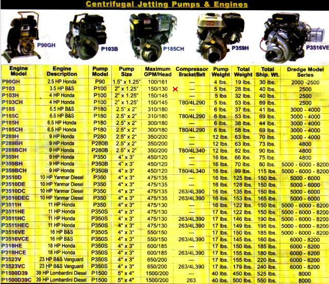
One of them is the 5000 gallon per day or less small miners' exclusion to permit fees...aka NO permit fee due and owing, and 5001 gpd or more is a $300 annual permit fee due and owing level with its own accompanying regs and headaches and filings, ad nauseum. QUOTE Here--in plain English--are the specifics as they were explained to me by a mining engineer so that all can see how the application of a mining engineering's principle called "push volume calculations according to industry standards" -- may and can be used to calculate disturbance, turbidity, etc., the crux of the 228.4a matter currently in our collective faces. FOUR (A through D) factors are listed below which can and will be used when push comes to shove --and we all know who is going to get shoved--in order to to calculate any operator's water usage according to personal equipment specs and most assuredly can and will be used AGAINST a small operator who the state or fed's deem is in the wrong. We're just dumb miners to the bureaucrats. They have the engineering science which they will pull out at their timing, and will surprise the small miner with science and math calculations. It is my belief that by posting some specifics regarding "Push volume" and "Draw gpm" volumetrics, this brief overview effort herein, will permit the current (and hopefully future) dredgers with the opportunity to estimate more closely--using the same mathematically supported facts--regarding YOUR water usage in OREGON in case you ever need to start to defend yourself, your hours in the water and your choice of equipment for results you are seeking, and most of all why you didn't purchase the $300 permit for water usage per day that exceeds the exclusionary provision. Frankly, Guys/Gals: Probably won't hurt to start keeping a Dredger's Log if you are already in the regulators hassling you hotseat...to show times of operation and places where you were using your gear. Ayup, long-haul trucking and mining may now have something ELSE in common--and a Dredger's Log Book requirement may just be coming shortly, who knows? It is my hope that anyone who has a dredge or a highbanker combo he or she would like to use within the state of Oregon waterways for the purpose of goldmining will print this out, use a highlighter to indicate YOUR equipment so that you can be armed with a semblance of facts if you get hassled out on your claim or in Oregon's waterways of ANY type in any locale. EDIT: July 24, 2004 It's only 5 months 'til Xmas eve!!! Do you know where your presents are?  PUSH VOLUME CALCS: Please be forwarned and prepared to understand before reading this next section that: : 1) Oregon WRD considers dredging and highbanking water "REMOVAL & Diversionary, and as such requires proper permitting in the eyes of the WRD (Water Resources Department--a state agency which has carved up Oregon into 12 water districts.) 2) the smallest of Keene pumps (P100) matched by Keene with a Briggs and Stratton 3.5HP (MODEL P103) using a 4" nozzle can and does exceed the 5000 gallon per day exclusion level where no permits are required from just being run LESS THAN 1 hour just based on Official Keene Pump Draw chart on page 28 of the latest Keene 2003 Product Catalog, ...at designed and engineered pump effeciency rating, with NO degradations for age or elevations. The Pump Draw for that Engine and Pump matched pair from Keene is 150 GPM. 60 min in an hour x 150gpm DRAW =9000 GPH, or legal usage of .55 hours if only drawing water from an regulated Oregon Waterway covered by WRD regulations. .55 hours??? YES! THAT's 33 minutes of actual dredging or highbanking with a 4" nozzle, with one of Keene's SMALLEST pump and engine combo's just to stay within Oregon's 5000 gpd exclusion from required fee stated permit payment "level." To be safe, Push Volumetrics on the above pump/engine/nozzle dictates that in stream per day time is reduced to about 10 minutes, guys/gals!!! And it is my clear understanding that PUSH VOLUME based on mfg pump specs is the metric used to prosecute violators of the 5000 gpd exclusion. Don't take my word for it...call your personal watermaster of YOUR district. MORE ABOUT PUSH VOLUME: PUSH VOLUME** Gallons Per Minute is calculated based on INDUSTRY STANDARD slurry density measurements--which takes into account these 4 factors: A ) particle size, B ) pump size, C ) nozzle size, and D ) aggregate type that one is moving through one's 4" nozzle,.... ....a dredger who wishes to work within the confines of Oregon WATER LAW's 5000 gal per day exclusion, has even LESS CLOCK TIME to dredge or highbank in Oregon public waters without the proper minimum $300 permit fee being due and owing. **Push Volume is the proper mining engineering term for the amount of watery slurry pushed up the nozzle and over the riffles. It is ALWAYS greater than pump DRAW in GPMin/GPHr/GPDay PUSH VOLUME is a mathematical calc based on INDUSTRY STANDARDS. I am not clear where to get ahold of a set of those "industry standards," but I'm willing to bet WRD / FS / BLM regulators know where to look and how to use those metrics!!!! Most dredgers/highbankers and placer miners have never heard of Push Volume nor are aware they are subject to this higher VOLUME standard when facing the prospects of being cited or fined for exceeding the Water Resources Department 5000 gpd exclusion as a "hobbyist/recreational" miner. Spread the word to every Dredger you know who operates in the Oregon Waterways. The wallet you save, may be your own. :( LINKS: OR--DEQ & WATERBOARD LINKS to permits & fees Oregon DEQ here http://www.deq.state.or.us/wq/search/query...ext+9+documents Oregon Water Resources Department here: http://www.wrd.state.or.us/fees/fees2003.pdf main page to search for Water Rights already extant, statewide, by legal description: http://www.wrd.state.or.us/publication/forms/index.shtml
Attached image(s)
|
 |
 
|
 |
|
Jul 28 2004, 09:27 AM
Post
#2
|
|
 Rock Bar! Group: Members Posts: 715 Joined: 28-October 03 From: The 45th Parallel in Oregon Member No.: 16 |
QUOTE (gold_tutor @ Jul 27 2004, 09:46 PM) Now... here's my other two concerns. 1) Please spend some time with your legal description and the URL in the top post so that you have already researched on line by legal, the person / company / corporation / forest district...whomever owns the water rights and for what purpose on that claim you be demonstrating from, okay? main page to search for Water Rights already extant, statewide, by legal description: http://www.wrd.state.or.us/publication/forms/index.shtml The coding is NOT easy to decipher and I never have found a legend. You'll be visiting with your district watermaster to decipher some of that code stuff. It's possible that no one will even bring it up. But I want you guys the best informed, most conscientious miners out there. Don't wear your marrying and burying suit, tho'....that looks like yer trying a little too hard. Print it out and have it with you. You can bet in the little stack of papers in the State Boy's front truck seat, will be that information!! Don't want you to get caught with your gawrsh shucks face on because you don't know before you get there and they tell you that you forgot something. If you can find those first water rights peeps, try your darnedest to locate and contact them for "permission" prior to the big demo day, k? 2) get a supply of sterile Urine sample bottles and sample every increment they sample, okay? Don't forget to have someone perform recon (with camera?) above you so that you know what the upstream situation is. Might get a weather report also for the week before so that you can document rainfall or any other natural event in that watershed above you prior to the big event. Later...gotta run. Megan Another valid point again Megan, points well taken !!. I did the research and found their are no water rights granted on this segment of river for 4 miles in every direction going back through the last 20 years of records. There are no agricultural areas, nor diversion points listed and here's how I did the work using your ideas that gave up a legend along with: I clicked the link you provided: Water Resources - Oregon Chose Water rights maps: Create Water Right Map and Taxlots from records Inputed the Correct Townships,Ranges, sections: Insert Townships and information to be shown **Note** Towards the lower right hand corner, make sure you choose the highest resolution for clarity. ( You can also export the info into a shapefile for use with ESRI, Globalmapper, ARCInfo etc. ) Within seconds the page ( after clicking "submit" ) will load and you MUST write down the next steps to take to go retrieve the file you requested ( takes seconds ) and although the page says a email will be sent to notify you when your file is complete...it is really there already and waiting for you... Make sure that all of you get the associated text file that accompanies the Image you asked for as it will explain just how to interpret the data processed ( easy to follow ) and print it out as well. Megan, THANKS Alot for covering our concerns. Rp |
|
|
|
 gold_tutor DREDGERS: Push Volume Info U NEED Jul 23 2004, 04:09 PM
 Redpaw Not picking a fight here, just opening up a conver... Jul 26 2004, 10:20 AM Redpaw On another note:
Suction dredge mining water usage... Jul 26 2004, 10:28 AM gold_tutor RE: Redpaw: Opening up for clarification what he d... Jul 26 2004, 12:30 PM Quilomene John Hey all,
I'm still digesting this info, but... Jul 26 2004, 02:21 PM Redpaw Talk to Mark Keene from engineering at Keene and h... Jul 26 2004, 02:25 PM Redpaw It was said:
Part of the reason I do not believe f... Jul 26 2004, 02:56 PM gold_tutor Hi, Redpaw. Good to see your thinking cap is perc... Jul 27 2004, 09:46 PM russau those are some very good points to be aware of... Jul 28 2004, 04:22 AM gold_tutor Nice work, Dave.
RE: only last 20 years...I think... Jul 28 2004, 10:40 AM Redpaw Bill Higbee at the Salem Water Resources Board tol... Jul 28 2004, 01:29 PM gold_tutor What a BEAUTIFUL example of the "state" ... Jul 28 2004, 08:32 PM Redpaw Yes Dear I did,
it was a little 3 x 5 card with m... Jul 28 2004, 11:21 PM
Redpaw Not picking a fight here, just opening up a conver... Jul 26 2004, 10:20 AM Redpaw On another note:
Suction dredge mining water usage... Jul 26 2004, 10:28 AM gold_tutor RE: Redpaw: Opening up for clarification what he d... Jul 26 2004, 12:30 PM Quilomene John Hey all,
I'm still digesting this info, but... Jul 26 2004, 02:21 PM Redpaw Talk to Mark Keene from engineering at Keene and h... Jul 26 2004, 02:25 PM Redpaw It was said:
Part of the reason I do not believe f... Jul 26 2004, 02:56 PM gold_tutor Hi, Redpaw. Good to see your thinking cap is perc... Jul 27 2004, 09:46 PM russau those are some very good points to be aware of... Jul 28 2004, 04:22 AM gold_tutor Nice work, Dave.
RE: only last 20 years...I think... Jul 28 2004, 10:40 AM Redpaw Bill Higbee at the Salem Water Resources Board tol... Jul 28 2004, 01:29 PM gold_tutor What a BEAUTIFUL example of the "state" ... Jul 28 2004, 08:32 PM Redpaw Yes Dear I did,
it was a little 3 x 5 card with m... Jul 28 2004, 11:21 PM Quilomene John Hey all,
Less than a handfull will still be a h... Jul 31 2004, 07:05 PM
Quilomene John Hey all,
Less than a handfull will still be a h... Jul 31 2004, 07:05 PM |
| Lo-Fi Version | Time is now: 12th July 2025 - 12:25 PM |


